Property Record
1933 Se 6Th St, Gresham, OR 97080
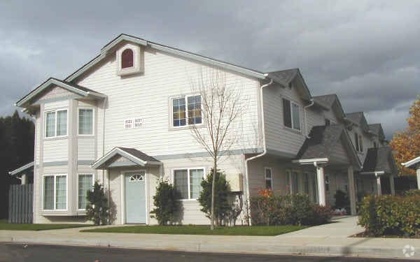
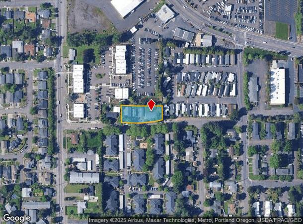
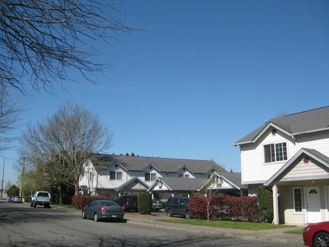

Property Detail
1933 Se 6Th St
R339437
Gresham
Quadruplex
SECTION 11 1S 3E, TL 1200 0.48 ACRES
X
Multnomah
41051C0406J
Oregon
2025
0.48 AC
2025
Mt Hood
010408
Portland
8,120 SF
Portland-Vancouver-Hillsboro, OR-WA
NEARBY LISTINGS FOR SALE OR LEASE
DEMOGRAPHICS near 1933 Se 6Th St
1 mile
3 mile
5 mile
2024 Total Population
17,154
94,108
176,321
2029 Population
16,634
92,015
172,581
Pop Growth 2024-2029
(3.03%)
(2.22%)
(2.12%)
Average Age
39
40
40
2024 Total Households
6,251
33,821
62,101
HH Growth 2024-2029
(3.42%)
(2.57%)
(2.47%)
Median Household Inc
$58,106
$72,025
$67,972
Avg Household Size
2.60
2.70
2.70
2024 Avg HH Vehicles
2.00
2.00
2.00
Median Home Value
$359,200
$403,341
$394,681
Median Year Built
1981
1984
1981
Nearby Places
Map Layers
Map Styles
 Street
 Aerial
Transit
 Traffic
 Biking
Places
Listings with unknown addresses are not visible on the map
- Restaurants
- Banks
- Shops
- Fitness
- Groceries
PUBLIC TRANSPORTATION
TRANSIT/SUBWAY
Cleveland Avenue (MAX Blue Line - Tri-County Metropolitan Transportation District of Oregon Rail (TriMet Rail))
Drive
Walk
Distance
Cleveland Avenue (MAX Blue Line - Tri-County Metropolitan Transportation District of Oregon Rail (TriMet Rail))
3 min
19 min
1.0 mi
AIRPORT
Portland International
Drive
Walk
Distance
Portland International
25 min
14.7 mi
Freight Ports
Port of Portland
Drive
Walk
Distance
Port of Portland
32 min
20.1 mi
SALE & LEASE HISTORY
LISTING DATE
SALE/LEASE

Dec 16, 2016
For Sale
Nearby Properties
Address
Land Use
TOTAL SIZE
Lot Size
Zoning
Address
Land Use
TOTAL SIZE
Lot Size
Zoning
40.81 AC
LDR-5
Address
Land Use
TOTAL SIZE
Lot Size
Zoning
Address
Land Use
TOTAL SIZE
Lot Size
Zoning
3.20 AC
DEM
Address
Land Use
TOTAL SIZE
Lot Size
Zoning
137.54 AC
GI
Address
Land Use
TOTAL SIZE
Lot Size
Zoning
300,843 SF
37.27 AC
MUA20
Address
Land Use
TOTAL SIZE
Lot Size
Zoning
302,114 SF
31.69 AC
R-5
Address
Land Use
TOTAL SIZE
Lot Size
Zoning
109,231 SF
7.87 AC
HI
Address
Land Use
TOTAL SIZE
Lot Size
Zoning
75,850 SF
11.55 AC
LDR-5
Address
Land Use
TOTAL SIZE
Lot Size
Zoning
8.69 AC
NULL
Address
Land Use
TOTAL SIZE
Lot Size
Zoning
836,366 SF
38.86 AC
LI
Address
Land Use
TOTAL SIZE
Lot Size
Zoning
197,834 SF
8.67 AC
R5
Address
Land Use
TOTAL SIZE
Lot Size
Zoning
237,815 SF
22.70 AC
TLDR
Address
Land Use
TOTAL SIZE
Lot Size
Zoning
118,460 SF
28.10 AC
BP
Address
Land Use
TOTAL SIZE
Lot Size
Zoning
273,264 SF
11.39 AC
CMF
Address
Land Use
TOTAL SIZE
Lot Size
Zoning
85,380 SF
5.04 AC
TD
Address
Land Use
TOTAL SIZE
Lot Size
Zoning
238,492 SF
13.10 AC
CMF
Address
Land Use
TOTAL SIZE
Lot Size
Zoning
254,580 SF
4.76 AC
TDHC
Address
Land Use
TOTAL SIZE
Lot Size
Zoning
733,232 SF
37.41 AC
NULL
Address
Land Use
TOTAL SIZE
Lot Size
Zoning
222,022 SF
11.64 AC
CMF
Address
Land Use
TOTAL SIZE
Lot Size
Zoning
83,072 SF
9.58 AC
LDR-5
Address
Land Use
TOTAL SIZE
Lot Size
Zoning
95,642 SF
5.30 AC
HI
Address
Land Use
TOTAL SIZE
Lot Size
Zoning
115,600 SF
28.24 AC
LDR-5
Address
Land Use
TOTAL SIZE
Lot Size
Zoning
61,524 SF
7.31 AC
LDR-5
Address
Land Use
TOTAL SIZE
Lot Size
Zoning
235,728 SF
6.64 AC
MDR-24
Address
Land Use
TOTAL SIZE
Lot Size
Zoning
141,899 SF
13.51 AC
DMU
Address
Land Use
TOTAL SIZE
Lot Size
Zoning
19.55 AC
GI
Address
Land Use
TOTAL SIZE
Lot Size
Zoning
87,429 SF
0.95 AC
DTM
Address
Land Use
TOTAL SIZE
Lot Size
Zoning
208,905 SF
10.17 AC
CMF
Address
Land Use
TOTAL SIZE
Lot Size
Zoning
97,430 SF
13.91 AC
HI
Address
Land Use
TOTAL SIZE
Lot Size
Zoning
95,901 SF
4.91 AC
CC
The World's #1 Commercial Real Estate Marketplace
Connect with us
© 2026 CoStar Group
The information above has been obtained from sources believed reliable. While we do not doubt its accuracy we have not verified it and make no guarantee, warranty or representation about it. It is your responsibility to independently confirm its accuracy and completeness. Any projections, opinions, assumptions, or estimates used are for example only and do not represent the current or future performance of the property. The value of this transaction to you depends on tax and other factors which should be evaluated by your tax, financial, and legal advisors. You and your advisors should conduct a careful, independent investigation of the property to determine to your satisfaction the suitability of the property for your needs.