Property Record
1933 Talmadge Rd, Allenhurst, GA 31301
NEARBY LISTINGS FOR SALE OR LEASE
-
-
View all Allenhurst listings for sale on LoopNet.com
Property Detail
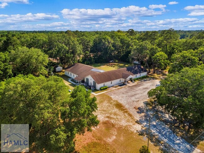
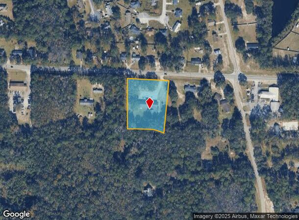
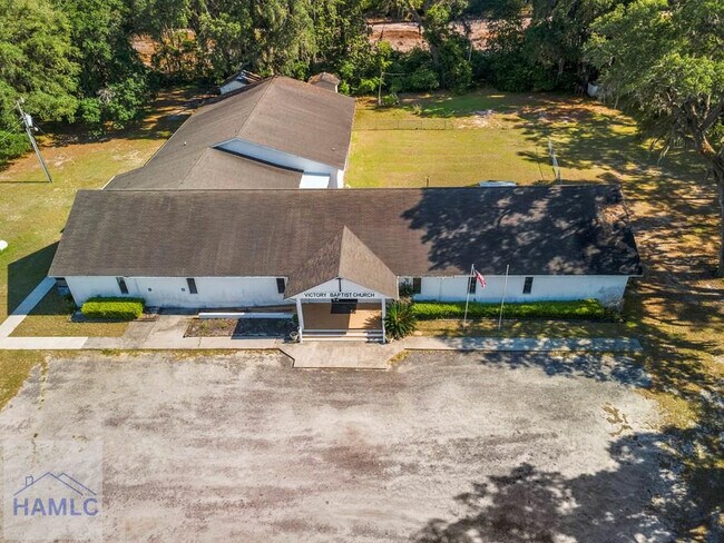
1933 Talmadge Rd
052B-011
2.06 AC
Religious
Liberty
X
Georgia
13179C0240E
2 AC
0
Liberty County
2024
Savannah
010204
Hinesville, GA
9,726 SF
DEMOGRAPHICS near 1933 Talmadge Rd
1 Mile
3 Mile
5 Mile
2024 Total Population
2,685
10,974
29,225
2029 Population
3,931
14,647
37,455
Pop Growth 2024-2029
+ 46.41%
+ 33.47%
+ 28.16%
Average Age
36
35
34
2024 Total Households
970
3,893
10,559
HH Growth 2024-2029
+ 44.95%
+ 33.09%
+ 27.64%
Median Household Inc
$40,100
$44,267
$47,005
Avg Household Size
2.70
2.70
2.70
2024 Avg HH Vehicles
2.00
2.00
2.00
Median Home Value
$110,169
$140,942
$141,460
Median Year Built
1992
1993
1991
Nearby Places
Map Layers
Map Styles
 Street
 Aerial
- Restaurants
- Banks
- Shops
- Fitness
- Groceries
SALE & LEASE HISTORY
LISTING DATE
SALE/LEASE

May 27, 2025
For Sale
Nearby Properties
Address
Land Use
TOTAL SIZE
Lot Size
Zoning
Address
Land Use
TOTAL SIZE
Lot Size
Zoning
11,944 SF
39.41 AC
LI
Address
Land Use
TOTAL SIZE
Lot Size
Zoning
81,366 SF
16.50 AC
R20
Address
Land Use
TOTAL SIZE
Lot Size
Zoning
71,899 SF
50.12 AC
LI
Address
Land Use
TOTAL SIZE
Lot Size
Zoning
53,103 SF
34.03 AC
I1
Address
Land Use
TOTAL SIZE
Lot Size
Zoning
42,572 SF
5.27 AC
C2
Address
Land Use
TOTAL SIZE
Lot Size
Zoning
13,500 SF
4.90 AC
LI
Address
Land Use
TOTAL SIZE
Lot Size
Zoning
23,314 SF
4.70 AC
C2/C3/R8
Address
Land Use
TOTAL SIZE
Lot Size
Zoning
29,704 SF
3.09 AC
AR1
Address
Land Use
TOTAL SIZE
Lot Size
Zoning
12,000 SF
4.14 AC
AR1
Address
Land Use
TOTAL SIZE
Lot Size
Zoning
2,000 SF
69 AC
LI
Address
Land Use
TOTAL SIZE
Lot Size
Zoning
27,129 SF
7.29 AC
LI
Address
Land Use
TOTAL SIZE
Lot Size
Zoning
76.06 AC
LI
Address
Land Use
TOTAL SIZE
Lot Size
Zoning
896 SF
1,795.11 AC
UNZONED RU
Address
Land Use
TOTAL SIZE
Lot Size
Zoning
115,570 SF
14.60 AC
I1
Address
Land Use
TOTAL SIZE
Lot Size
Zoning
8,881 SF
11.57 AC
R20
Address
Land Use
TOTAL SIZE
Lot Size
Zoning
1,481.10 AC
A1
Address
Land Use
TOTAL SIZE
Lot Size
Zoning
20,000 SF
37.93 AC
COMMERCIAL
Address
Land Use
TOTAL SIZE
Lot Size
Zoning
1,632 SF
2.97 AC
C3
Address
Land Use
TOTAL SIZE
Lot Size
Zoning
4,560 SF
2.58 AC
C3
Address
Land Use
TOTAL SIZE
Lot Size
Zoning
8,320 SF
1.66 AC
C3
Address
Land Use
TOTAL SIZE
Lot Size
Zoning
18.44 AC
PUD
Address
Land Use
TOTAL SIZE
Lot Size
Zoning
3,600 SF
2.45 AC
C2
Address
Land Use
TOTAL SIZE
Lot Size
Zoning
11,328 SF
5.34 AC
R20
Address
Land Use
TOTAL SIZE
Lot Size
Zoning
761.91 AC
A1
Address
Land Use
TOTAL SIZE
Lot Size
Zoning
10,640 SF
1.56 AC
C3
Address
Land Use
TOTAL SIZE
Lot Size
Zoning
10,740 SF
1.25 AC
C3
Address
Land Use
TOTAL SIZE
Lot Size
Zoning
4,800 SF
3 AC
R12
Address
Land Use
TOTAL SIZE
Lot Size
Zoning
896 SF
714.45 AC
UNZONED RU
Address
Land Use
TOTAL SIZE
Lot Size
Zoning
28.93 AC
C3/MHP
Address
Land Use
TOTAL SIZE
Lot Size
Zoning
4,800 SF
1.50 AC
C2
The World's #1 Commercial Real Estate Marketplace
Connect with us
© 2026 CoStar Group
The information above has been obtained from sources believed reliable. While we do not doubt its accuracy we have not verified it and make no guarantee, warranty or representation about it. It is your responsibility to independently confirm its accuracy and completeness. Any projections, opinions, assumptions, or estimates used are for example only and do not represent the current or future performance of the property. The value of this transaction to you depends on tax and other factors which should be evaluated by your tax, financial, and legal advisors. You and your advisors should conduct a careful, independent investigation of the property to determine to your satisfaction the suitability of the property for your needs.