Property Record
19331 Neuralia Rd, California City, CA 93505
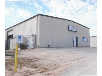
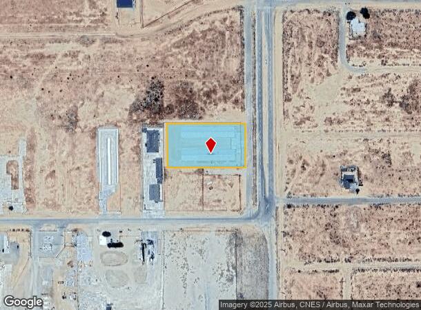
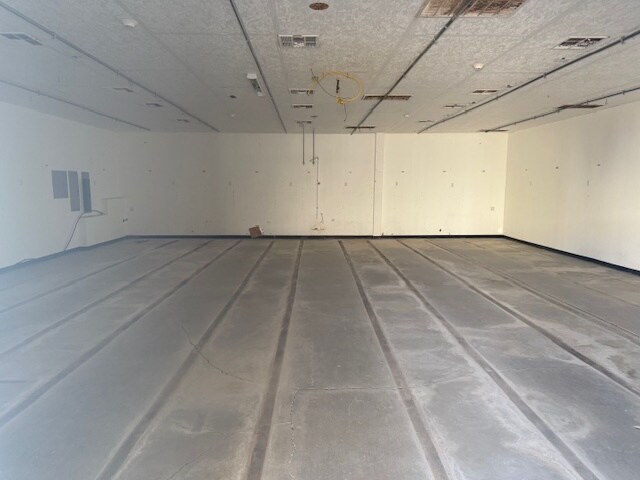
This Property Is For Sale
NEARBY LISTINGS FOR SALE OR LEASE
-
-
View all California City listings for sale on LoopNet.com
Property Detail
19331 Neuralia Rd
206-042-23-00-3
TRACT 2123 , BLOCK , LOT 84
Farms
Kern
A
California
06029C3326E
84
2024
1 AC
2025
NE Outlying Kern County
005511
Bakersfield
12,500 SF
Bakersfield, CA
DEMOGRAPHICS near 19331 Neuralia Rd
1 Mile
3 Mile
5 Mile
2024 Total Population
1,381
10,967
14,054
2029 Population
1,378
11,129
14,291
Pop Growth 2024-2029
(0.22%)
+ 1.48%
+ 1.69%
Average Age
37
36
37
2024 Total Households
483
3,915
5,012
HH Growth 2024-2029
(0.21%)
+ 1.35%
+ 1.56%
Median Household Inc
$67,350
$40,319
$44,048
Avg Household Size
2.90
2.80
2.80
2024 Avg HH Vehicles
2.00
2.00
2.00
Median Home Value
$218,571
$195,849
$205,745
Median Year Built
1992
1992
1993
Nearby Places
- Restaurants
- Banks
- Shops
- Fitness
- Groceries
Nearby Properties
Address
Land Use
TOTAL SIZE
Lot Size
Zoning
Address
Land Use
TOTAL SIZE
Lot Size
Zoning
10 AC
M-1
Address
Land Use
TOTAL SIZE
Lot Size
Zoning
20,878 SF
3.53 AC
C2
Address
Land Use
TOTAL SIZE
Lot Size
Zoning
30,900 SF
9.89 AC
M-1
Address
Land Use
TOTAL SIZE
Lot Size
Zoning
2,400 SF
0.90 AC
M2
Address
Land Use
TOTAL SIZE
Lot Size
Zoning
33,272 SF
3.03 AC
C5
Address
Land Use
TOTAL SIZE
Lot Size
Zoning
16,734 SF
1.26 AC
C5
Address
Land Use
TOTAL SIZE
Lot Size
Zoning
4,200 SF
0.36 AC
Address
Land Use
TOTAL SIZE
Lot Size
Zoning
8,320 SF
1.24 AC
GC
Address
Land Use
TOTAL SIZE
Lot Size
Zoning
16,140 SF
9.66 AC
CC
Address
Land Use
TOTAL SIZE
Lot Size
Zoning
5,600 SF
1 AC
M-1
Address
Land Use
TOTAL SIZE
Lot Size
Zoning
2,006 SF
1.21 AC
C-5
Address
Land Use
TOTAL SIZE
Lot Size
Zoning
65,967 SF
5 AC
M-1
Address
Land Use
TOTAL SIZE
Lot Size
Zoning
3,567 SF
0.71 AC
C5
Address
Land Use
TOTAL SIZE
Lot Size
Zoning
6,768 SF
1.19 AC
CO
Address
Land Use
TOTAL SIZE
Lot Size
Zoning
9,610 SF
0.75 AC
C2
Address
Land Use
TOTAL SIZE
Lot Size
Zoning
0.90 AC
M-2
Address
Land Use
TOTAL SIZE
Lot Size
Zoning
4,033 SF
2 AC
C2
Address
Land Use
TOTAL SIZE
Lot Size
Zoning
7,550 SF
0.49 AC
C4
Address
Land Use
TOTAL SIZE
Lot Size
Zoning
2,880 SF
0.53 AC
C1
Address
Land Use
TOTAL SIZE
Lot Size
Zoning
209,000 SF
0.98 AC
M-1
Address
Land Use
TOTAL SIZE
Lot Size
Zoning
4,400 SF
1 AC
C1
Address
Land Use
TOTAL SIZE
Lot Size
Zoning
5,624 SF
0.29 AC
C2
Address
Land Use
TOTAL SIZE
Lot Size
Zoning
3,312 SF
2.98 AC
O/RA
Address
Land Use
TOTAL SIZE
Lot Size
Zoning
3,016 SF
0.29 AC
RM1/RM2
Address
Land Use
TOTAL SIZE
Lot Size
Zoning
960 SF
1 AC
M1
Address
Land Use
TOTAL SIZE
Lot Size
Zoning
6,032 SF
0.29 AC
RM1/RM2
Address
Land Use
TOTAL SIZE
Lot Size
Zoning
8,560 SF
2.84 AC
O/RA
Address
Land Use
TOTAL SIZE
Lot Size
Zoning
6,750 SF
0.50 AC
C2
Address
Land Use
TOTAL SIZE
Lot Size
Zoning
15,000 SF
1.80 AC
Address
Land Use
TOTAL SIZE
Lot Size
Zoning
6,500 SF
0.47 AC
C2
The World's #1 Commercial Real Estate Marketplace
Connect with us
© 2025 CoStar Group
The information above has been obtained from sources believed reliable. While we do not doubt its accuracy we have not verified it and make no guarantee, warranty or representation about it. It is your responsibility to independently confirm its accuracy and completeness. Any projections, opinions, assumptions, or estimates used are for example only and do not represent the current or future performance of the property. The value of this transaction to you depends on tax and other factors which should be evaluated by your tax, financial, and legal advisors. You and your advisors should conduct a careful, independent investigation of the property to determine to your satisfaction the suitability of the property for your needs.