Property Record
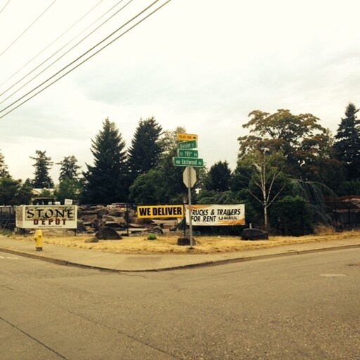
19333 Se Division St, Gresham, OR 97030
Property Detail
19333 Se Division St
Portland-Vancouver-Hillsboro, OR-WA
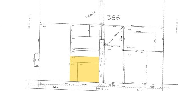
VANCE, W 80 OF S 250 OF E 1/2 OF LOT 15 EXC PT IN ST
R293278
MULTNOMAH
Commercialacreage
Oregon
MC
15
B and X Area of moderate flood hazard, usually the area between the limits of the 100-year and 500-year floods.
1.13 AC
2025
Gresham
2025
Portland
010001
NEARBY LISTINGS FOR SALE OR LEASE
DEMOGRAPHICS near 19333 Se Division St
1 mile
3 mile
5 mile
2024 Total Population
18,538
138,939
275,091
2029 Population
18,117
135,880
269,528
Pop Growth 2024-2029
(2.27%)
(2.20%)
(2.02%)
Average Age
38
39
40
2024 Total Households
6,306
49,311
97,123
HH Growth 2024-2029
(2.66%)
(2.53%)
(2.36%)
Median Household Inc
$63,831
$59,961
$65,928
Avg Household Size
2.80
2.70
2.70
2024 Avg HH Vehicles
2.00
2.00
2.00
Median Home Value
$364,137
$370,659
$393,802
Median Year Built
1977
1979
1979
Nearby Places
Map Layers
Map Styles
 Street
 Aerial
Transit
 Traffic
 Biking
Places
Listings with unknown addresses are not visible on the map
- Restaurants
- Banks
- Shops
- Fitness
- Groceries
PUBLIC TRANSPORTATION
AIRPORT
Portland International
Drive
Walk
Distance
Portland International
21 min
12.2 mi
Freight Ports
Port of Portland
Drive
Walk
Distance
Port of Portland
28 min
17.6 mi
Nearby Properties
Address
Land Use
TOTAL SIZE
Lot Size
Zoning
Address
Land Use
TOTAL SIZE
Lot Size
Zoning
21.39 AC
NULL
Address
Land Use
TOTAL SIZE
Lot Size
Zoning
3,800 SF
27.96 AC
LI
Address
Land Use
TOTAL SIZE
Lot Size
Zoning
Address
Land Use
TOTAL SIZE
Lot Size
Zoning
3.20 AC
DEM
Address
Land Use
TOTAL SIZE
Lot Size
Zoning
64.20 AC
HI
Address
Land Use
TOTAL SIZE
Lot Size
Zoning
137.54 AC
GI
Address
Land Use
TOTAL SIZE
Lot Size
Zoning
365,000 SF
38.87 AC
GI
Address
Land Use
TOTAL SIZE
Lot Size
Zoning
260,995 SF
6.49 AC
RTC
Address
Land Use
TOTAL SIZE
Lot Size
Zoning
698,484 SF
34.21 AC
GI
Address
Land Use
TOTAL SIZE
Lot Size
Zoning
109,231 SF
7.87 AC
HI
Address
Land Use
TOTAL SIZE
Lot Size
Zoning
75,850 SF
11.55 AC
LDR-5
Address
Land Use
TOTAL SIZE
Lot Size
Zoning
123,716 SF
20.03 AC
LDR-5
Address
Land Use
TOTAL SIZE
Lot Size
Zoning
8.69 AC
NULL
Address
Land Use
TOTAL SIZE
Lot Size
Zoning
836,366 SF
38.86 AC
LI
Address
Land Use
TOTAL SIZE
Lot Size
Zoning
21.39 AC
HI
Address
Land Use
TOTAL SIZE
Lot Size
Zoning
197,834 SF
8.67 AC
R5
Address
Land Use
TOTAL SIZE
Lot Size
Zoning
237,815 SF
22.70 AC
TLDR
Address
Land Use
TOTAL SIZE
Lot Size
Zoning
191,466 SF
34.68 AC
R/CSP
Address
Land Use
TOTAL SIZE
Lot Size
Zoning
219,470 SF
9.77 AC
R_MF
Address
Land Use
TOTAL SIZE
Lot Size
Zoning
129,462 SF
15.90 AC
R7
Address
Land Use
TOTAL SIZE
Lot Size
Zoning
118,460 SF
28.10 AC
BP
Address
Land Use
TOTAL SIZE
Lot Size
Zoning
357,603 SF
22.69 AC
GI
Address
Land Use
TOTAL SIZE
Lot Size
Zoning
85,380 SF
5.04 AC
TD
Address
Land Use
TOTAL SIZE
Lot Size
Zoning
258,564 SF
20.56 AC
LDR7
Address
Land Use
TOTAL SIZE
Lot Size
Zoning
86,138 SF
5.93 AC
R7
Address
Land Use
TOTAL SIZE
Lot Size
Zoning
238,492 SF
13.10 AC
CMF
Address
Land Use
TOTAL SIZE
Lot Size
Zoning
254,580 SF
4.76 AC
TDHC
Address
Land Use
TOTAL SIZE
Lot Size
Zoning
304,649 SF
14.13 AC
GI
Address
Land Use
TOTAL SIZE
Lot Size
Zoning
733,232 SF
37.41 AC
NULL
Address
Land Use
TOTAL SIZE
Lot Size
Zoning
222,022 SF
11.64 AC
CMF
The World's #1 Commercial Real Estate Marketplace
Connect with us
© 2026 CoStar Group
The information above has been obtained from sources believed reliable. While we do not doubt its accuracy we have not verified it and make no guarantee, warranty or representation about it. It is your responsibility to independently confirm its accuracy and completeness. Any projections, opinions, assumptions, or estimates used are for example only and do not represent the current or future performance of the property. The value of this transaction to you depends on tax and other factors which should be evaluated by your tax, financial, and legal advisors. You and your advisors should conduct a careful, independent investigation of the property to determine to your satisfaction the suitability of the property for your needs.