Property Record
1935 Kingstown Rd, Wakefield, RI 02879
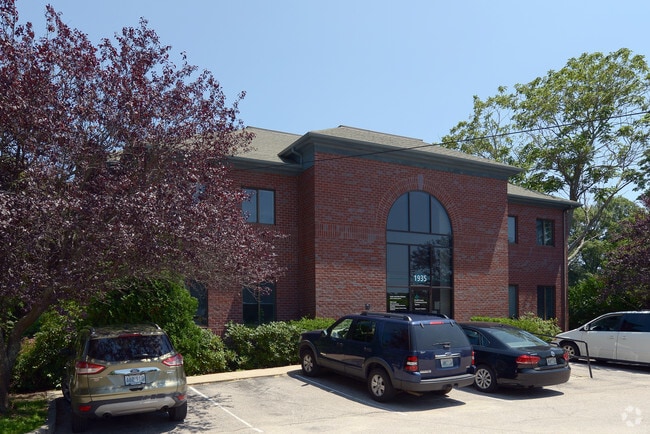

Property Detail
1935 Kingstown Rd
SKIN-004001-000000-000014
Washington
Charitableorganization
Rhode Island
MU
14
B and X Area of moderate flood hazard, usually the area between the limits of the 100-year and 500-year floods.
1.35 AC
2020
Washington County
2025
Providence
051305
Providence-Warwick, RI-MA
18,791 SF
NEARBY LISTINGS FOR SALE OR LEASE
DEMOGRAPHICS near 1935 Kingstown Rd
1 mile
3 mile
5 mile
2025 Total Population
3,416
22,850
41,698
2030 Population
3,334
22,411
41,421
Pop Growth 2025-2030
(2.40%)
(1.92%)
(0.66%)
Average Age
43
39
42
2025 Total Households
1,363
7,073
15,033
HH Growth 2025-2030
(3.08%)
(2.76%)
(0.82%)
Median Household Inc
$102,296
$105,529
$110,002
Avg Household Size
2.30
2.30
2.30
2025 Avg HH Vehicles
2.00
2.00
2.00
Median Home Value
$527,472
$565,046
$642,600
Median Year Built
1983
1977
1977
Nearby Places
Map Layers
Map Styles
 Street
 Aerial
Layers
 Traffic
 Biking
Places
Listings with unknown addresses are not visible on the map
- Restaurants
- Banks
- Shops
- Fitness
- Groceries
PUBLIC TRANSPORTATION
COMMUTER RAIL
Kingston Amtrak Station (Northeast Regional - Amtrak)
Drive
Walk
Distance
Kingston Amtrak Station (Northeast Regional - Amtrak)
9 min
3.3 mi
AIRPORT
Rhode Island Tf Green International
Drive
Walk
Distance
Rhode Island Tf Green International
40 min
25.3 mi
Freight Ports
Port of Davisville, RI
Drive
Walk
Distance
Port of Davisville, RI
31 min
15.1 mi
SALE & LEASE HISTORY
LISTING DATE
SALE/LEASE

Sep 24, 2016
For Sale
Nearby Properties
Address
Land Use
TOTAL SIZE
Lot Size
Zoning
Address
Land Use
TOTAL SIZE
Lot Size
Zoning
8.03 AC
GI
Address
Land Use
TOTAL SIZE
Lot Size
Zoning
17.06 AC
GI
Address
Land Use
TOTAL SIZE
Lot Size
Zoning
16.50 AC
GI
Address
Land Use
TOTAL SIZE
Lot Size
Zoning
245,692 SF
11.12 AC
GI
Address
Land Use
TOTAL SIZE
Lot Size
Zoning
35.38 AC
B-B
Address
Land Use
TOTAL SIZE
Lot Size
Zoning
151,375 SF
12.17 AC
SMD
Address
Land Use
TOTAL SIZE
Lot Size
Zoning
10 AC
SMD
Address
Land Use
TOTAL SIZE
Lot Size
Zoning
50.78 AC
GI
Address
Land Use
TOTAL SIZE
Lot Size
Zoning
25.32 AC
GI
Address
Land Use
TOTAL SIZE
Lot Size
Zoning
88,358 SF
20.25 AC
P
Address
Land Use
TOTAL SIZE
Lot Size
Zoning
74,782 SF
6.16 AC
MU
Address
Land Use
TOTAL SIZE
Lot Size
Zoning
6.50 AC
SMD
Address
Land Use
TOTAL SIZE
Lot Size
Zoning
150.79 AC
GI
Address
Land Use
TOTAL SIZE
Lot Size
Zoning
24.81 AC
GI
Address
Land Use
TOTAL SIZE
Lot Size
Zoning
15.20 AC
SMD
Address
Land Use
TOTAL SIZE
Lot Size
Zoning
91,020 SF
6.95 AC
RM
Address
Land Use
TOTAL SIZE
Lot Size
Zoning
85,477 SF
6.23 AC
GI
Address
Land Use
TOTAL SIZE
Lot Size
Zoning
340.80 AC
GI
Address
Land Use
TOTAL SIZE
Lot Size
Zoning
13.34 AC
CH
Address
Land Use
TOTAL SIZE
Lot Size
Zoning
41.50 AC
GI
Address
Land Use
TOTAL SIZE
Lot Size
Zoning
6.22 AC
RM
Address
Land Use
TOTAL SIZE
Lot Size
Zoning
4.81 AC
GI
Address
Land Use
TOTAL SIZE
Lot Size
Zoning
6.09 AC
GI
Address
Land Use
TOTAL SIZE
Lot Size
Zoning
5.03 AC
CH
Address
Land Use
TOTAL SIZE
Lot Size
Zoning
63,563 SF
13.25 AC
R80
Address
Land Use
TOTAL SIZE
Lot Size
Zoning
4.45 AC
GI
Address
Land Use
TOTAL SIZE
Lot Size
Zoning
57,663 SF
1.45 AC
GI
Address
Land Use
TOTAL SIZE
Lot Size
Zoning
10.03 AC
GI
Address
Land Use
TOTAL SIZE
Lot Size
Zoning
86,735 SF
25 AC
RM
Address
Land Use
TOTAL SIZE
Lot Size
Zoning
4.47 AC
B-B
The World's #1 Commercial Real Estate Marketplace
Connect with us
© 2026 CoStar Group
The information above has been obtained from sources believed reliable. While we do not doubt its accuracy we have not verified it and make no guarantee, warranty or representation about it. It is your responsibility to independently confirm its accuracy and completeness. Any projections, opinions, assumptions, or estimates used are for example only and do not represent the current or future performance of the property. The value of this transaction to you depends on tax and other factors which should be evaluated by your tax, financial, and legal advisors. You and your advisors should conduct a careful, independent investigation of the property to determine to your satisfaction the suitability of the property for your needs.