Property Record
19350 W 159Th St, Olathe, KS 66062
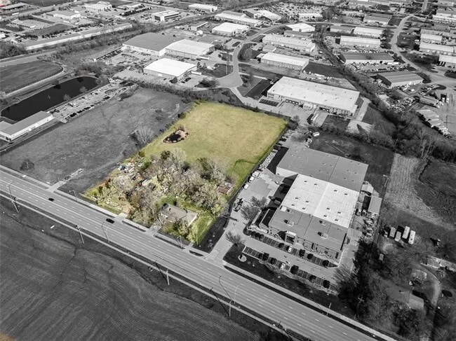
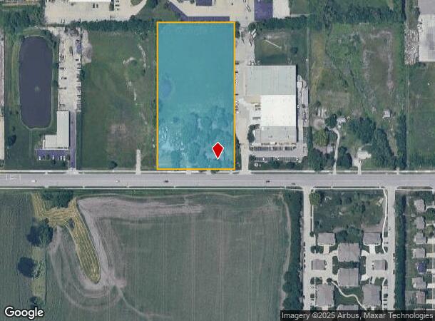
This Property Is For Sale
NEARBY LISTINGS FOR SALE OR LEASE
Property Detail
19350 W 159Th St
DF231412-2025
12-14-23 W 330 E 1056 S 1/2 S 1/2 SW 1/4 EX .2274 AC IN ST4.7726 ACS M/L OLC 475C
Farms
Johnson
X
Kansas
20091C0109G
4.77 AC
2024
South Johnson County
2024
Kansas City
053509
Kansas City, MO-KS
3,580 SF
DEMOGRAPHICS near 19350 W 159Th St
1 Mile
3 Mile
5 Mile
2024 Total Population
6,380
53,295
130,241
2029 Population
6,668
55,292
135,610
Pop Growth 2024-2029
+ 4.51%
+ 3.75%
+ 4.12%
Average Age
36
37
37
2024 Total Households
2,235
18,275
45,093
HH Growth 2024-2029
+ 4.70%
+ 3.92%
+ 4.26%
Median Household Inc
$111,644
$96,798
$100,270
Avg Household Size
2.80
2.80
2.80
2024 Avg HH Vehicles
2.00
2.00
2.00
Median Home Value
$286,983
$278,276
$296,496
Median Year Built
2000
1987
1992
Nearby Places
- Restaurants
- Banks
- Shops
- Fitness
- Groceries
Nearby Properties
Address
Land Use
TOTAL SIZE
Lot Size
Zoning
Address
Land Use
TOTAL SIZE
Lot Size
Zoning
401,604 SF
28.35 AC
CP-O
Address
Land Use
TOTAL SIZE
Lot Size
Zoning
512,643 SF
75.55 AC
AG
Address
Land Use
TOTAL SIZE
Lot Size
Zoning
97,340 SF
1.82 AC
C-2
Address
Land Use
TOTAL SIZE
Lot Size
Zoning
211,054 SF
77.48 AC
R-1
Address
Land Use
TOTAL SIZE
Lot Size
Zoning
130,576 SF
15.20 AC
RP-4
Address
Land Use
TOTAL SIZE
Lot Size
Zoning
720,320 SF
39.19 AC
MP-2
Address
Land Use
TOTAL SIZE
Lot Size
Zoning
177,274 SF
2.69 AC
C-2
Address
Land Use
TOTAL SIZE
Lot Size
Zoning
320,835 SF
57.95 AC
M-2
Address
Land Use
TOTAL SIZE
Lot Size
Zoning
508,664 SF
29.46 AC
MP-2
Address
Land Use
TOTAL SIZE
Lot Size
Zoning
103,102 SF
31.90 AC
R-1
Address
Land Use
TOTAL SIZE
Lot Size
Zoning
251,981 SF
10.79 AC
R-5
Address
Land Use
TOTAL SIZE
Lot Size
Zoning
499,084 SF
28.99 AC
RUR
Address
Land Use
TOTAL SIZE
Lot Size
Zoning
129,325 SF
4.50 AC
R-1
Address
Land Use
TOTAL SIZE
Lot Size
Zoning
137,955 SF
23.80 AC
R-1
Address
Land Use
TOTAL SIZE
Lot Size
Zoning
137,122 SF
7.68 AC
C-1
Address
Land Use
TOTAL SIZE
Lot Size
Zoning
934,106 SF
34.09 AC
BP
Address
Land Use
TOTAL SIZE
Lot Size
Zoning
157,344 SF
12.69 AC
R-1
Address
Land Use
TOTAL SIZE
Lot Size
Zoning
188,944 SF
31.48 AC
R-1
Address
Land Use
TOTAL SIZE
Lot Size
Zoning
236,108 SF
12.38 AC
R-1
Address
Land Use
TOTAL SIZE
Lot Size
Zoning
228,577 SF
17.11 AC
M-2
Address
Land Use
TOTAL SIZE
Lot Size
Zoning
64,953 SF
32.62 AC
CTY RUR
Address
Land Use
TOTAL SIZE
Lot Size
Zoning
71,221 SF
17.13 AC
R-1
Address
Land Use
TOTAL SIZE
Lot Size
Zoning
117,084 SF
10.69 AC
R-1
Address
Land Use
TOTAL SIZE
Lot Size
Zoning
71,221 SF
13.84 AC
R-1
Address
Land Use
TOTAL SIZE
Lot Size
Zoning
244,992 SF
15.75 AC
MP-2
Address
Land Use
TOTAL SIZE
Lot Size
Zoning
212,032 SF
9.53 AC
RUR
Address
Land Use
TOTAL SIZE
Lot Size
Zoning
72,091 SF
11.33 AC
R-1
Address
Land Use
TOTAL SIZE
Lot Size
Zoning
205,752 SF
15.50 AC
M-2
Address
Land Use
TOTAL SIZE
Lot Size
Zoning
92,328 SF
9.49 AC
M-1
Address
Land Use
TOTAL SIZE
Lot Size
Zoning
69,723 SF
11.29 AC
R-1
The World's #1 Commercial Real Estate Marketplace
Connect with us
© 2025 CoStar Group
The information above has been obtained from sources believed reliable. While we do not doubt its accuracy we have not verified it and make no guarantee, warranty or representation about it. It is your responsibility to independently confirm its accuracy and completeness. Any projections, opinions, assumptions, or estimates used are for example only and do not represent the current or future performance of the property. The value of this transaction to you depends on tax and other factors which should be evaluated by your tax, financial, and legal advisors. You and your advisors should conduct a careful, independent investigation of the property to determine to your satisfaction the suitability of the property for your needs.