Property Record
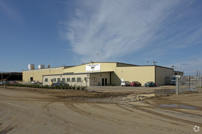
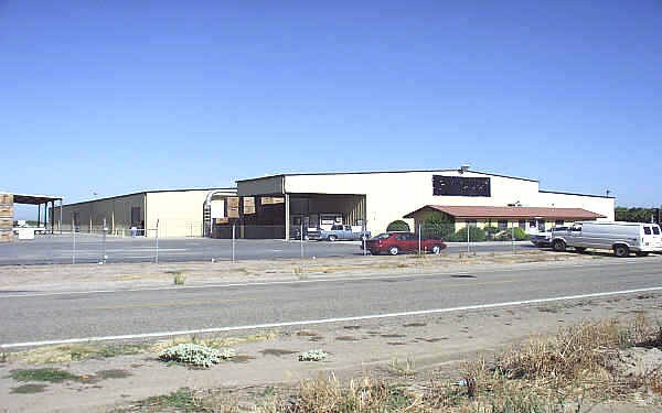
19368 Road 19, Madera, CA 93637


Property Detail
19368 Road 19
028-030-023
FAIRMEAD COL 7 SEC 27 T10S R16E 15/117-1 & 2 LLA
Foodprocessing
MADERA
ARE-20
California
B and X Area of moderate flood hazard, usually the area between the limits of the 100-year and 500-year floods.
28.44 AC
2024
Outlying Madera Cnty
2025
Fresno
000203
Fresno, CA
37,307 SF
NEARBY LISTINGS FOR SALE OR LEASE
-
-
View all Madera listings for sale on LoopNet.com
DEMOGRAPHICS near 19368 Road 19
1 mile
3 mile
5 mile
2025 Total Population
55
2,195
6,064
2030 Population
55
2,249
6,235
Pop Growth 2025-2030
0.00%
+ 2.46%
+ 2.82%
Average Age
36
39
39
2025 Total Households
16
306
800
HH Growth 2025-2030
0.00%
+ 2.61%
+ 3.75%
Median Household Inc
$55,999
$57,631
$55,794
Avg Household Size
3.30
3.30
3.30
2025 Avg HH Vehicles
2.00
3.00
3.00
Median Home Value
$466,666
$467,441
$431,603
Median Year Built
1972
1975
1984
Nearby Places
Map Layers
Map Styles
 Street
 Aerial
Layers
 Traffic
 Biking
Places
Listings with unknown addresses are not visible on the map
- Restaurants
- Banks
- Shops
- Fitness
- Groceries
PUBLIC TRANSPORTATION
AIRPORT
Fresno Yosemite International
Drive
Walk
Distance
Fresno Yosemite International
49 min
35.7 mi
Nearby Properties
Address
Land Use
TOTAL SIZE
Lot Size
Zoning
Address
Land Use
TOTAL SIZE
Lot Size
Zoning
29,000 SF
37.32 AC
IL
Address
Land Use
TOTAL SIZE
Lot Size
Zoning
3,660 SF
1.40 AC
IL
Address
Land Use
TOTAL SIZE
Lot Size
Zoning
151.02 AC
ARE-40
Address
Land Use
TOTAL SIZE
Lot Size
Zoning
2,018 SF
76.29 AC
ARE-40
Address
Land Use
TOTAL SIZE
Lot Size
Zoning
37.70 AC
ARE-40
Address
Land Use
TOTAL SIZE
Lot Size
Zoning
78.20 AC
ARE-20
Address
Land Use
TOTAL SIZE
Lot Size
Zoning
1,400 SF
80.71 AC
ARE-20
Address
Land Use
TOTAL SIZE
Lot Size
Zoning
1,723 SF
92.96 AC
ARE-40
Address
Land Use
TOTAL SIZE
Lot Size
Zoning
2,845 SF
318.48 AC
ARE-20
Address
Land Use
TOTAL SIZE
Lot Size
Zoning
1,238 SF
78.02 AC
ARE-40
Address
Land Use
TOTAL SIZE
Lot Size
Zoning
12,800 SF
18 AC
ARE-20
Address
Land Use
TOTAL SIZE
Lot Size
Zoning
1,692 SF
59.82 AC
ARE-20
Address
Land Use
TOTAL SIZE
Lot Size
Zoning
4,084 SF
106.31 AC
ARE-40
Address
Land Use
TOTAL SIZE
Lot Size
Zoning
8,000 SF
15.81 AC
ARE-20
Address
Land Use
TOTAL SIZE
Lot Size
Zoning
1,248 SF
55.39 AC
ARE-20
Address
Land Use
TOTAL SIZE
Lot Size
Zoning
2,984 SF
154.98 AC
ARE-40
Address
Land Use
TOTAL SIZE
Lot Size
Zoning
1,114 SF
116.09 AC
ARE-20
Address
Land Use
TOTAL SIZE
Lot Size
Zoning
798 SF
157.22 AC
ARE-40
Address
Land Use
TOTAL SIZE
Lot Size
Zoning
728 SF
77.13 AC
ARE-40
Address
Land Use
TOTAL SIZE
Lot Size
Zoning
1,512 SF
77.84 AC
ARE-20
Address
Land Use
TOTAL SIZE
Lot Size
Zoning
2,294 SF
78.60 AC
ARE-20
Address
Land Use
TOTAL SIZE
Lot Size
Zoning
1,764 SF
38.21 AC
AR-5
Address
Land Use
TOTAL SIZE
Lot Size
Zoning
1,937 SF
59.53 AC
ARE-40
Address
Land Use
TOTAL SIZE
Lot Size
Zoning
39.90 AC
ARE-20
Address
Land Use
TOTAL SIZE
Lot Size
Zoning
2,022 SF
29.45 AC
AR-5
Address
Land Use
TOTAL SIZE
Lot Size
Zoning
480 SF
38.43 AC
ARE-20
Address
Land Use
TOTAL SIZE
Lot Size
Zoning
120 AC
ARE-20
Address
Land Use
TOTAL SIZE
Lot Size
Zoning
1,200 SF
36.34 AC
ARE-20
The World's #1 Commercial Real Estate Marketplace
Connect with us
© 2026 CoStar Group
The information above has been obtained from sources believed reliable. While we do not doubt its accuracy we have not verified it and make no guarantee, warranty or representation about it. It is your responsibility to independently confirm its accuracy and completeness. Any projections, opinions, assumptions, or estimates used are for example only and do not represent the current or future performance of the property. The value of this transaction to you depends on tax and other factors which should be evaluated by your tax, financial, and legal advisors. You and your advisors should conduct a careful, independent investigation of the property to determine to your satisfaction the suitability of the property for your needs.