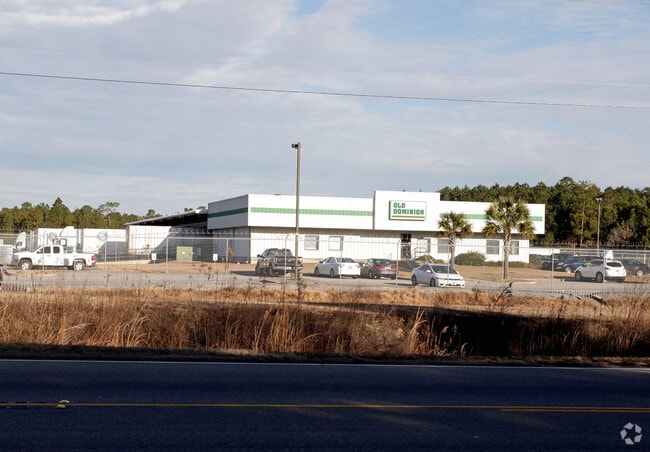
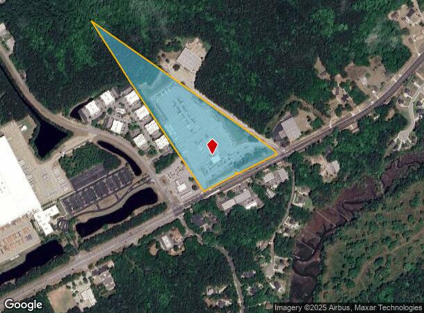
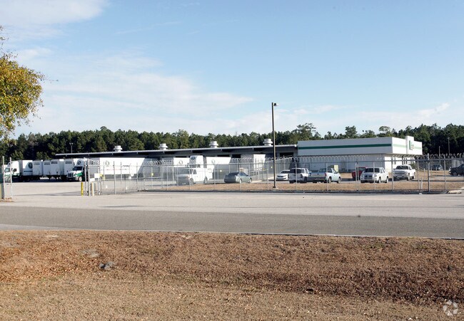
Property Record
1938 Clements Ferry Rd, Charleston, SC 29492
NEARBY LISTINGS FOR SALE OR LEASE
Property Detail
1938 Clements Ferry Rd
268-00-00-076
Cainhoy Commercial
Commercialnec
ASSESSMENT DISTRICT: 914WAREHOUSE (DISTR)
X
Berkeley
45015C0720E
South Carolina
2025
16.99 AC
2025
Daniel Island
020404
Charleston/N Charleston
16,600 SF
Charleston-North Charleston, SC
DEMOGRAPHICS near 1938 Clements Ferry Rd
1 Mile
3 Mile
5 Mile
2024 Total Population
1,879
9,650
38,558
2029 Population
2,291
11,692
44,136
Pop Growth 2024-2029
+ 21.93%
+ 21.16%
+ 14.47%
Average Age
37
38
40
2024 Total Households
817
4,028
15,162
HH Growth 2024-2029
+ 22.15%
+ 21.40%
+ 15.06%
Median Household Inc
$90,858
$105,781
$110,352
Avg Household Size
2.30
2.40
2.50
2024 Avg HH Vehicles
2.00
2.00
2.00
Median Home Value
$482,098
$517,373
$587,158
Median Year Built
2010
2010
2007
Nearby Places
Map Layers
Map Styles
 Street
 Aerial
- Restaurants
- Banks
- Shops
- Fitness
- Groceries
PUBLIC TRANSPORTATION
COMMUTER RAIL
Charleston Amtrak Station (Palmetto - Amtrak, Silver Meteor - Amtrak)
DRIVE
WALK
Distance
Charleston Amtrak Station (Palmetto - Amtrak, Silver Meteor - Amtrak)
16 min
9.9 mi
AIRPORT
Charleston AFB/International
DRIVE
WALK
Distance
Charleston AFB/International
24 min
15.4 mi
Freight Ports
Wando Welch Terminal
DRIVE
WALK
Distance
Wando Welch Terminal
15 min
9.8 mi
Nearby Properties
Address
Land Use
TOTAL SIZE
Lot Size
Zoning
Address
Land Use
TOTAL SIZE
Lot Size
Zoning
28,677 SF
15.56 AC
BERKELEY C
Address
Land Use
TOTAL SIZE
Lot Size
Zoning
349,670 SF
21.61 AC
CHARLESTON
Address
Land Use
TOTAL SIZE
Lot Size
Zoning
626,148 SF
59.38 AC
CHARLESTON
Address
Land Use
TOTAL SIZE
Lot Size
Zoning
79,408 SF
3.11 AC
CHARLESTON
Address
Land Use
TOTAL SIZE
Lot Size
Zoning
870 SF
14.87 AC
BERKELEY C
Address
Land Use
TOTAL SIZE
Lot Size
Zoning
278,800 SF
18.17 AC
CHARLESTON
Address
Land Use
TOTAL SIZE
Lot Size
Zoning
48,057 SF
8.50 AC
CHARLESTON
Address
Land Use
TOTAL SIZE
Lot Size
Zoning
351,000 SF
17.66 AC
CHARLESTON
Address
Land Use
TOTAL SIZE
Lot Size
Zoning
351,000 SF
27.58 AC
CHARLESTON
Address
Land Use
TOTAL SIZE
Lot Size
Zoning
300,000 SF
20.85 AC
CHARLESTON
Address
Land Use
TOTAL SIZE
Lot Size
Zoning
250,000 SF
28.97 AC
CHARLESTON
Address
Land Use
TOTAL SIZE
Lot Size
Zoning
3,929 SF
2.35 AC
CHARLESTON
Address
Land Use
TOTAL SIZE
Lot Size
Zoning
260,000 SF
14.33 AC
CHARLESTON
Address
Land Use
TOTAL SIZE
Lot Size
Zoning
75,005 SF
14.66 AC
CHARLESTON
Address
Land Use
TOTAL SIZE
Lot Size
Zoning
203,200 SF
20.16 AC
BERKELEY C
Address
Land Use
TOTAL SIZE
Lot Size
Zoning
83,421 SF
3.66 AC
CHARLESTON
Address
Land Use
TOTAL SIZE
Lot Size
Zoning
53,661 SF
485.86 AC
CHARLESTON
Address
Land Use
TOTAL SIZE
Lot Size
Zoning
190,175 SF
24.36 AC
CHARLESTON
Address
Land Use
TOTAL SIZE
Lot Size
Zoning
6,000 SF
4.35 AC
CHARLESTON
Address
Land Use
TOTAL SIZE
Lot Size
Zoning
200,000 SF
15.25 AC
CHARLESTON
Address
Land Use
TOTAL SIZE
Lot Size
Zoning
83,215 SF
1.98 AC
CHARLESTON
Address
Land Use
TOTAL SIZE
Lot Size
Zoning
112,000 SF
7.02 AC
CHARLESTON
Address
Land Use
TOTAL SIZE
Lot Size
Zoning
160.87 AC
CHARLESTON
Address
Land Use
TOTAL SIZE
Lot Size
Zoning
55,614 SF
4.56 AC
CHARLESTON
Address
Land Use
TOTAL SIZE
Lot Size
Zoning
19.46 AC
CHARLESTON
Address
Land Use
TOTAL SIZE
Lot Size
Zoning
50,400 SF
6.80 AC
CHARLESTON
Address
Land Use
TOTAL SIZE
Lot Size
Zoning
27,375 SF
16.07 AC
CHARLESTON
Address
Land Use
TOTAL SIZE
Lot Size
Zoning
4,250 SF
1.70 AC
CHARLESTON
Address
Land Use
TOTAL SIZE
Lot Size
Zoning
19.50 AC
CHARLESTON
Address
Land Use
TOTAL SIZE
Lot Size
Zoning
8,440 SF
2.68 AC
CHARLESTON
The World's #1 Commercial Real Estate Marketplace
Connect with us
© 2026 CoStar Group
The information above has been obtained from sources believed reliable. While we do not doubt its accuracy we have not verified it and make no guarantee, warranty or representation about it. It is your responsibility to independently confirm its accuracy and completeness. Any projections, opinions, assumptions, or estimates used are for example only and do not represent the current or future performance of the property. The value of this transaction to you depends on tax and other factors which should be evaluated by your tax, financial, and legal advisors. You and your advisors should conduct a careful, independent investigation of the property to determine to your satisfaction the suitability of the property for your needs.