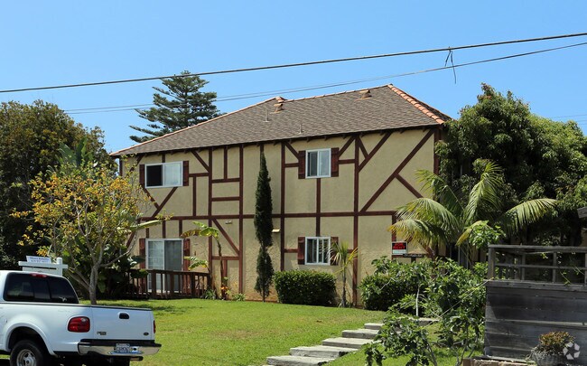
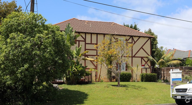
Property Record
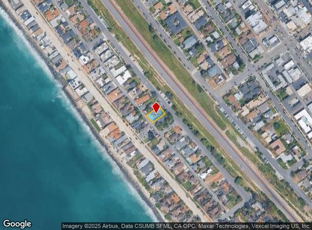
1939 S Myers St, Oceanside, CA 92054
NEARBY LISTINGS FOR SALE OR LEASE
Property Detail
1939 S Myers St
San Diego-Carlsbad, CA
South Oceanside Corr
153-251-33
BLK 6 LOT J TR 000622
Multifamilydwelling
San Diego
X
California
06073C0761H
j
2024
0.14 AC
2025
South Oceanside
018102
San Diego
3,982 SF
DEMOGRAPHICS near 1939 S Myers St
1 Mile
3 Mile
5 Mile
2024 Total Population
9,149
74,238
158,444
2029 Population
9,214
74,290
158,109
Pop Growth 2024-2029
+ 0.71%
+ 0.07%
(0.21%)
Average Age
43
41
40
2024 Total Households
4,153
30,569
59,130
HH Growth 2024-2029
+ 0.82%
+ 0.24%
(0.16%)
Median Household Inc
$90,522
$80,213
$80,098
Avg Household Size
2.10
2.30
2.50
2024 Avg HH Vehicles
2.00
2.00
2.00
Median Home Value
$893,919
$852,745
$763,712
Median Year Built
1969
1976
1981
Nearby Places
Map Layers
Map Styles
 Street
 Aerial
- Restaurants
- Banks
- Shops
- Fitness
- Groceries
PUBLIC TRANSPORTATION
COMMUTER RAIL
Carlsbad Village (Coaster - San Diego North County Transit District (Coaster/Sprinter/Breeze))
DRIVE
WALK
Distance
Carlsbad Village (Coaster - San Diego North County Transit District (Coaster/Sprinter/Breeze))
6 min
1.7 mi
Oceanside Transit Center (Orange County Line - Southern California Regional Rail Authority (Metrolink))
DRIVE
WALK
Distance
Oceanside Transit Center (Orange County Line - Southern California Regional Rail Authority (Metrolink))
7 min
2.0 mi
AIRPORT
San Diego International
DRIVE
WALK
Distance
San Diego International
46 min
34.9 mi
Freight Ports
Port of San Diego
DRIVE
WALK
Distance
Port of San Diego
51 min
39.3 mi
Nearby Properties
Address
Land Use
TOTAL SIZE
Lot Size
Zoning
Address
Land Use
TOTAL SIZE
Lot Size
Zoning
59,518 SF
5.70 AC
P-U
Address
Land Use
TOTAL SIZE
Lot Size
Zoning
1.38 AC
C
Address
Land Use
TOTAL SIZE
Lot Size
Zoning
5.28 AC
C2
Address
Land Use
TOTAL SIZE
Lot Size
Zoning
16 AC
P-C
Address
Land Use
TOTAL SIZE
Lot Size
Zoning
1.38 AC
C
Address
Land Use
TOTAL SIZE
Lot Size
Zoning
4.26 AC
C-2
Address
Land Use
TOTAL SIZE
Lot Size
Zoning
1.77 AC
C-2
Address
Land Use
TOTAL SIZE
Lot Size
Zoning
1.14 AC
C
Address
Land Use
TOTAL SIZE
Lot Size
Zoning
60.48 AC
OS
Address
Land Use
TOTAL SIZE
Lot Size
Zoning
85,000 SF
4.40 AC
CC
Address
Land Use
TOTAL SIZE
Lot Size
Zoning
19.51 AC
C-2-Q
Address
Land Use
TOTAL SIZE
Lot Size
Zoning
10.63 AC
RD-M
Address
Land Use
TOTAL SIZE
Lot Size
Zoning
1.02 AC
D-1
Address
Land Use
TOTAL SIZE
Lot Size
Zoning
2.30 AC
V-R
Address
Land Use
TOTAL SIZE
Lot Size
Zoning
4.68 AC
D-6B
Address
Land Use
TOTAL SIZE
Lot Size
Zoning
6.63 AC
RD-M
Address
Land Use
TOTAL SIZE
Lot Size
Zoning
57,905 SF
2.16 AC
R-3
Address
Land Use
TOTAL SIZE
Lot Size
Zoning
1.34 AC
V-B
Address
Land Use
TOTAL SIZE
Lot Size
Zoning
64,722 SF
2.17 AC
D-1
Address
Land Use
TOTAL SIZE
Lot Size
Zoning
6,024 SF
6.92 AC
VC
Address
Land Use
TOTAL SIZE
Lot Size
Zoning
92,481 SF
9.53 AC
CG-PBD
Address
Land Use
TOTAL SIZE
Lot Size
Zoning
9.59 AC
RD-M-Q
Address
Land Use
TOTAL SIZE
Lot Size
Zoning
59,587 SF
0.69 AC
V-R
Address
Land Use
TOTAL SIZE
Lot Size
Zoning
68,630 SF
1.30 AC
C-2
Address
Land Use
TOTAL SIZE
Lot Size
Zoning
96,942 SF
4.49 AC
R-3
Address
Land Use
TOTAL SIZE
Lot Size
Zoning
66,816 SF
9.55 AC
RH
Address
Land Use
TOTAL SIZE
Lot Size
Zoning
9.52 AC
CS-HO
Address
Land Use
TOTAL SIZE
Lot Size
Zoning
10.15 AC
P-C
Address
Land Use
TOTAL SIZE
Lot Size
Zoning
2.67 AC
C-6
Address
Land Use
TOTAL SIZE
Lot Size
Zoning
70,000 SF
1.75 AC
V-R
The World's #1 Commercial Real Estate Marketplace
Connect with us
© 2025 CoStar Group
The information above has been obtained from sources believed reliable. While we do not doubt its accuracy we have not verified it and make no guarantee, warranty or representation about it. It is your responsibility to independently confirm its accuracy and completeness. Any projections, opinions, assumptions, or estimates used are for example only and do not represent the current or future performance of the property. The value of this transaction to you depends on tax and other factors which should be evaluated by your tax, financial, and legal advisors. You and your advisors should conduct a careful, independent investigation of the property to determine to your satisfaction the suitability of the property for your needs.