Property Record
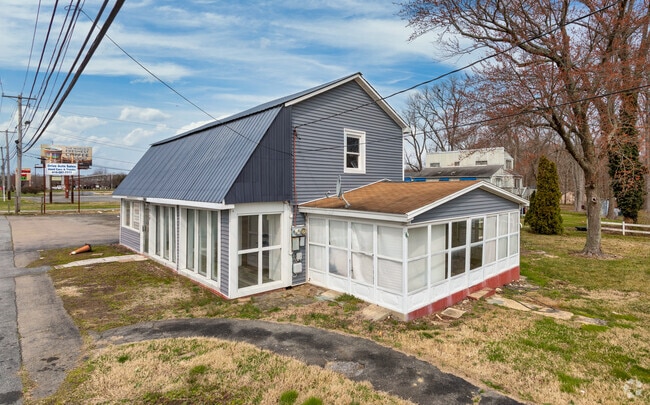
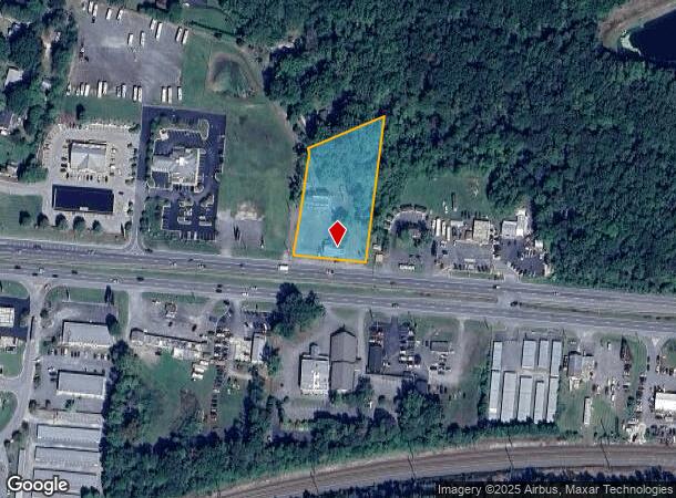
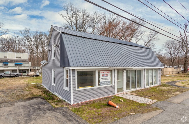
1939 W Pulaski Hwy, Elkton, MD 21921
NEARBY LISTINGS FOR SALE OR LEASE
Property Detail
1939 W Pulaski Hwy
05-021278
1.7 ACRE 1939 PULASKI HIGHWAY N/E OF NORTH EAST
Storebuilding
Cecil
X
Maryland
24015C0156D
1.70 AC
2025
Cecil County
2025
Baltimore
030908
Philadelphia-Camden-Wilmington, PA-NJ-DE-MD
2,613 SF
DEMOGRAPHICS near 1939 W Pulaski Hwy
1 Mile
3 Mile
5 Mile
2024 Total Population
4,766
17,097
34,188
2029 Population
4,981
17,691
35,270
Pop Growth 2024-2029
+ 4.51%
+ 3.47%
+ 3.16%
Average Age
38
39
40
2024 Total Households
1,802
6,512
12,664
HH Growth 2024-2029
+ 4.50%
+ 3.53%
+ 3.28%
Median Household Inc
$74,715
$75,675
$79,351
Avg Household Size
2.60
2.60
2.60
2024 Avg HH Vehicles
2.00
2.00
2.00
Median Home Value
$216,964
$273,414
$305,696
Median Year Built
1996
1996
1992
Nearby Places
Map Layers
Map Styles
 Street
 Aerial
- Restaurants
- Banks
- Shops
- Fitness
- Groceries
PUBLIC TRANSPORTATION
COMMUTER RAIL
Perryville (PENN - WASHINGTON - Maryland Area Regional Commuter Trains (The MARC), Penn Line - Maryland Area Regional Commuter Trains (The MARC))
DRIVE
WALK
Distance
Perryville (PENN - WASHINGTON - Maryland Area Regional Commuter Trains (The MARC), Penn Line - Maryland Area Regional Commuter Trains (The MARC))
13 min
9.1 mi
Freight Ports
Port of Wilmington, RI
DRIVE
WALK
Distance
Port of Wilmington, RI
35 min
25.0 mi
SALE & LEASE HISTORY
LISTING DATE
SALE/LEASE

Sep 24, 2016
For Sale
Nearby Properties
Address
Land Use
TOTAL SIZE
Lot Size
Zoning
Address
Land Use
TOTAL SIZE
Lot Size
Zoning
10,000 SF
50.29 AC
HCHCO
Address
Land Use
TOTAL SIZE
Lot Size
Zoning
28,506 SF
20.23 AC
RM
Address
Land Use
TOTAL SIZE
Lot Size
Zoning
64,000 SF
99.85 AC
ST
Address
Land Use
TOTAL SIZE
Lot Size
Zoning
502,200 SF
50.87 AC
M2
Address
Land Use
TOTAL SIZE
Lot Size
Zoning
193,440 SF
36.74 AC
M1
Address
Land Use
TOTAL SIZE
Lot Size
Zoning
116,097 SF
64.11 AC
M1
Address
Land Use
TOTAL SIZE
Lot Size
Zoning
9,920 SF
27.68 AC
M1
Address
Land Use
TOTAL SIZE
Lot Size
Zoning
43,634 SF
3.52 AC
I
Address
Land Use
TOTAL SIZE
Lot Size
Zoning
201,694 SF
18.98 AC
BI
Address
Land Use
TOTAL SIZE
Lot Size
Zoning
69,721 SF
59.50 AC
ST
Address
Land Use
TOTAL SIZE
Lot Size
Zoning
23,800 SF
8.72 AC
BI
Address
Land Use
TOTAL SIZE
Lot Size
Zoning
9,944 SF
98.33 AC
UR
Address
Land Use
TOTAL SIZE
Lot Size
Zoning
121,404 SF
19.65 AC
HC
Address
Land Use
TOTAL SIZE
Lot Size
Zoning
142,582 SF
74 AC
RM
Address
Land Use
TOTAL SIZE
Lot Size
Zoning
4,020 SF
76.79 AC
M2
Address
Land Use
TOTAL SIZE
Lot Size
Zoning
60,850 SF
11.75 AC
R1
Address
Land Use
TOTAL SIZE
Lot Size
Zoning
77,905 SF
9.22 AC
I
Address
Land Use
TOTAL SIZE
Lot Size
Zoning
2,400.63 AC
OS
Address
Land Use
TOTAL SIZE
Lot Size
Zoning
105,041 SF
9.89 AC
R1
Address
Land Use
TOTAL SIZE
Lot Size
Zoning
170.50 AC
BG
Address
Land Use
TOTAL SIZE
Lot Size
Zoning
38,400 SF
11.42 AC
BI
Address
Land Use
TOTAL SIZE
Lot Size
Zoning
50,819 SF
1.10 AC
C2
Address
Land Use
TOTAL SIZE
Lot Size
Zoning
1,184 SF
101.71 AC
BI
Address
Land Use
TOTAL SIZE
Lot Size
Zoning
1,800 SF
43.92 AC
CM2
Address
Land Use
TOTAL SIZE
Lot Size
Zoning
30.71 AC
MH
Address
Land Use
TOTAL SIZE
Lot Size
Zoning
76,540 SF
20.58 AC
M1
Address
Land Use
TOTAL SIZE
Lot Size
Zoning
50,920 SF
5.01 AC
M1
Address
Land Use
TOTAL SIZE
Lot Size
Zoning
10,169 SF
18.04 AC
M1
Address
Land Use
TOTAL SIZE
Lot Size
Zoning
2,916 SF
139.53 AC
MEA
Address
Land Use
TOTAL SIZE
Lot Size
Zoning
16.10 AC
SPLIT
The World's #1 Commercial Real Estate Marketplace
Connect with us
© 2025 CoStar Group
The information above has been obtained from sources believed reliable. While we do not doubt its accuracy we have not verified it and make no guarantee, warranty or representation about it. It is your responsibility to independently confirm its accuracy and completeness. Any projections, opinions, assumptions, or estimates used are for example only and do not represent the current or future performance of the property. The value of this transaction to you depends on tax and other factors which should be evaluated by your tax, financial, and legal advisors. You and your advisors should conduct a careful, independent investigation of the property to determine to your satisfaction the suitability of the property for your needs.