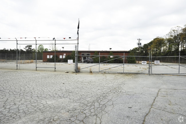
Property Record
1952 Moreland Ave Se, Atlanta, GA 30316

Current Lease Availabilities
NEARBY LISTINGS FOR SALE OR LEASE
Property Detail
1952 Moreland Ave Se
15-112-01-010
100 X 990 X 100 X 990 . . . . .2.27AC 11-1-88
Officebuilding
DeKalb
X
Georgia
13121C0378F
8
2025
9.20 AC
2025
Airport/North Clayton
023802
Atlanta
6,300 SF
Atlanta-Sandy Springs-Roswell, GA
DEMOGRAPHICS near 1952 Moreland Ave Se
1 Mile
3 Mile
5 Mile
2024 Total Population
8,949
79,220
273,453
2029 Population
9,295
81,999
280,971
Pop Growth 2024-2029
+ 3.87%
+ 3.51%
+ 2.75%
Average Age
35
37
37
2024 Total Households
2,930
32,141
116,432
HH Growth 2024-2029
+ 4.06%
+ 3.64%
+ 3.01%
Median Household Inc
$42,899
$64,568
$66,782
Avg Household Size
2.50
2.30
2.20
2024 Avg HH Vehicles
1.00
1.00
1.00
Median Home Value
$291,040
$343,016
$346,819
Median Year Built
1969
1975
1978
Nearby Places
- Restaurants
- Banks
- Shops
- Fitness
- Groceries
PUBLIC TRANSPORTATION
AIRPORT
Hartsfield - Jackson Atlanta International
DRIVE
WALK
Distance
Hartsfield - Jackson Atlanta International
18 min
9.0 mi
Nearby Properties
Address
Land Use
TOTAL SIZE
Lot Size
Zoning
Address
Land Use
TOTAL SIZE
Lot Size
Zoning
432,056 SF
17.87 AC
C1
Address
Land Use
TOTAL SIZE
Lot Size
Zoning
595,658 SF
4.09 AC
I1
Address
Land Use
TOTAL SIZE
Lot Size
Zoning
94.93 AC
R5
Address
Land Use
TOTAL SIZE
Lot Size
Zoning
54 AC
I2
Address
Land Use
TOTAL SIZE
Lot Size
Zoning
566,872 SF
3.31 AC
I1
Address
Land Use
TOTAL SIZE
Lot Size
Zoning
624,087 SF
4.45 AC
I2
Address
Land Use
TOTAL SIZE
Lot Size
Zoning
436,143 SF
2.90 AC
I1
Address
Land Use
TOTAL SIZE
Lot Size
Zoning
330,125 SF
7.16 AC
I1
Address
Land Use
TOTAL SIZE
Lot Size
Zoning
400,347 SF
3.30 AC
I2
Address
Land Use
TOTAL SIZE
Lot Size
Zoning
444,229 SF
2.76 AC
I1
Address
Land Use
TOTAL SIZE
Lot Size
Zoning
828,718 SF
2.60 AC
I1
Address
Land Use
TOTAL SIZE
Lot Size
Zoning
1,128,762 SF
10.39 AC
I2
Address
Land Use
TOTAL SIZE
Lot Size
Zoning
521,674 SF
2.91 AC
I2
Address
Land Use
TOTAL SIZE
Lot Size
Zoning
344,551 SF
9.94 AC
I2
Address
Land Use
TOTAL SIZE
Lot Size
Zoning
260,649 SF
4 AC
R5
Address
Land Use
TOTAL SIZE
Lot Size
Zoning
373,594 SF
2.32 AC
I1
Address
Land Use
TOTAL SIZE
Lot Size
Zoning
318,300 SF
4.60 AC
I1
Address
Land Use
TOTAL SIZE
Lot Size
Zoning
105,624 SF
11.62 AC
MR-2
Address
Land Use
TOTAL SIZE
Lot Size
Zoning
376,702 SF
5.61 AC
RG3
Address
Land Use
TOTAL SIZE
Lot Size
Zoning
381,983 SF
52.54 AC
M
Address
Land Use
TOTAL SIZE
Lot Size
Zoning
389,641 SF
2.97 AC
I1
Address
Land Use
TOTAL SIZE
Lot Size
Zoning
254,990 SF
1.95 AC
C2
Address
Land Use
TOTAL SIZE
Lot Size
Zoning
324,371 SF
2.55 AC
I2
Address
Land Use
TOTAL SIZE
Lot Size
Zoning
1.23 AC
I2
Address
Land Use
TOTAL SIZE
Lot Size
Zoning
313,734 SF
22.60 AC
R5
Address
Land Use
TOTAL SIZE
Lot Size
Zoning
74,593 SF
2.16 AC
NC1
Address
Land Use
TOTAL SIZE
Lot Size
Zoning
295,632 SF
19.26 AC
RM75
Address
Land Use
TOTAL SIZE
Lot Size
Zoning
381,923 SF
19.72 AC
M
Address
Land Use
TOTAL SIZE
Lot Size
Zoning
59,246 SF
3.99 AC
X
Address
Land Use
TOTAL SIZE
Lot Size
Zoning
7.65 AC
R5
The World's #1 Commercial Real Estate Marketplace
Connect with us
© 2025 CoStar Group
The information above has been obtained from sources believed reliable. While we do not doubt its accuracy we have not verified it and make no guarantee, warranty or representation about it. It is your responsibility to independently confirm its accuracy and completeness. Any projections, opinions, assumptions, or estimates used are for example only and do not represent the current or future performance of the property. The value of this transaction to you depends on tax and other factors which should be evaluated by your tax, financial, and legal advisors. You and your advisors should conduct a careful, independent investigation of the property to determine to your satisfaction the suitability of the property for your needs.