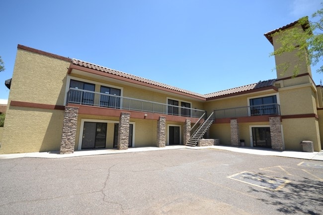
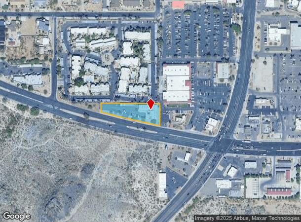
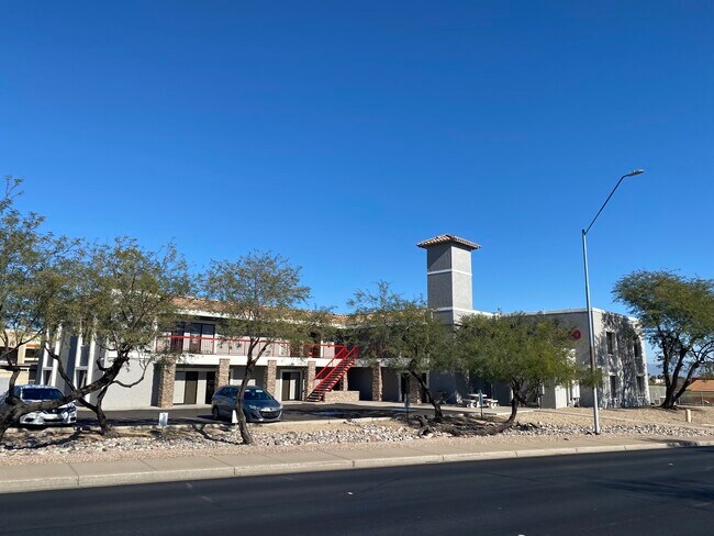
Property Record
1940 E Thunderbird Rd, Phoenix, AZ 85022

Current Lease Availabilities
Property Detail
1940 E Thunderbird Rd
166-19-009D
E 390F OF TH PT SE4 SW4 LY S OF N 1035F EX ANY PT LY W/IN THUNDERBIRD RD & EX S 5F PER D/P 12876/1 86
Officebuilding
Maricopa
X
Arizona
04013C1735L
30
2025
1.01 AC
2025
Paradise Valley
103701
Phoenix
15,424 SF
Phoenix-Mesa-Chandler, AZ
NEARBY LISTINGS FOR SALE OR LEASE
DEMOGRAPHICS near 1940 E Thunderbird Rd
1 mile
3 mile
5 mile
2024 Total Population
10,047
102,649
328,860
2029 Population
10,865
110,623
355,607
Pop Growth 2024-2029
+ 8.14%
+ 7.77%
+ 8.13%
Average Age
43
41
40
2024 Total Households
4,360
42,364
137,477
HH Growth 2024-2029
+ 8.26%
+ 7.89%
+ 8.31%
Median Household Inc
$59,902
$73,389
$68,990
Avg Household Size
2.20
2.30
2.30
2024 Avg HH Vehicles
2.00
2.00
2.00
Median Home Value
$404,052
$411,793
$409,404
Median Year Built
1980
1978
1982
Nearby Places
Map Layers
Map Styles
 Street
 Aerial
Transit
 Traffic
 Biking
Places
Listings with unknown addresses are not visible on the map
- Restaurants
- Banks
- Shops
- Fitness
- Groceries
PUBLIC TRANSPORTATION
AIRPORT
Phoenix Sky Harbor International
Drive
Walk
Distance
Phoenix Sky Harbor International
25 min
16.1 mi
Phoenix-Mesa Gateway
Drive
Walk
Distance
Phoenix-Mesa Gateway
59 min
43.3 mi
Nearby Properties
Address
Land Use
TOTAL SIZE
Lot Size
Zoning
Address
Land Use
TOTAL SIZE
Lot Size
Zoning
128,046 SF
9.97 AC
C2
Address
Land Use
TOTAL SIZE
Lot Size
Zoning
558,361 SF
14.61 AC
C-2
Address
Land Use
TOTAL SIZE
Lot Size
Zoning
215,150 SF
13.24 AC
R-3
Address
Land Use
TOTAL SIZE
Lot Size
Zoning
512,499 SF
23.03 AC
R3A
Address
Land Use
TOTAL SIZE
Lot Size
Zoning
323,288 SF
40.56 AC
R1-10
Address
Land Use
TOTAL SIZE
Lot Size
Zoning
452,506 SF
55.11 AC
RH
Address
Land Use
TOTAL SIZE
Lot Size
Zoning
3.27 AC
C-C
Address
Land Use
TOTAL SIZE
Lot Size
Zoning
211,239 SF
12.33 AC
M-M
Address
Land Use
TOTAL SIZE
Lot Size
Zoning
358,670 SF
18.14 AC
M-H
Address
Land Use
TOTAL SIZE
Lot Size
Zoning
281,018 SF
9.26 AC
M-H
Address
Land Use
TOTAL SIZE
Lot Size
Zoning
123,370 SF
0.82 AC
C-C
Address
Land Use
TOTAL SIZE
Lot Size
Zoning
120,494 SF
11.17 AC
C-C
Address
Land Use
TOTAL SIZE
Lot Size
Zoning
115,983 SF
4.85 AC
R-14
Address
Land Use
TOTAL SIZE
Lot Size
Zoning
84,738 SF
8.83 AC
R-6
Address
Land Use
TOTAL SIZE
Lot Size
Zoning
362,106 SF
15.60 AC
M-H
Address
Land Use
TOTAL SIZE
Lot Size
Zoning
81,692 SF
8.65 AC
R-10
Address
Land Use
TOTAL SIZE
Lot Size
Zoning
180,205 SF
11.53 AC
C-C
Address
Land Use
TOTAL SIZE
Lot Size
Zoning
110,623 SF
4.39 AC
R-10
Address
Land Use
TOTAL SIZE
Lot Size
Zoning
435,890 SF
16.51 AC
R5
Address
Land Use
TOTAL SIZE
Lot Size
Zoning
341,747 SF
17.61 AC
R-2
Address
Land Use
TOTAL SIZE
Lot Size
Zoning
855 SF
156.18 AC
R-10
Address
Land Use
TOTAL SIZE
Lot Size
Zoning
166,715 SF
13.02 AC
C-C
Address
Land Use
TOTAL SIZE
Lot Size
Zoning
77,582 SF
9.18 AC
R-6
Address
Land Use
TOTAL SIZE
Lot Size
Zoning
87,218 SF
13.95 AC
R-10
Address
Land Use
TOTAL SIZE
Lot Size
Zoning
78.23 AC
R-10
Address
Land Use
TOTAL SIZE
Lot Size
Zoning
81,269 SF
9.21 AC
R-14
Address
Land Use
TOTAL SIZE
Lot Size
Zoning
96,307 SF
9.04 AC
PUD
Address
Land Use
TOTAL SIZE
Lot Size
Zoning
68,115 SF
13.26 AC
R-10
Address
Land Use
TOTAL SIZE
Lot Size
Zoning
83,110 SF
7.18 AC
C-N
Address
Land Use
TOTAL SIZE
Lot Size
Zoning
216,456 SF
56.11 AC
R1-8
The World's #1 Commercial Real Estate Marketplace
Connect with us
© 2026 CoStar Group
The information above has been obtained from sources believed reliable. While we do not doubt its accuracy we have not verified it and make no guarantee, warranty or representation about it. It is your responsibility to independently confirm its accuracy and completeness. Any projections, opinions, assumptions, or estimates used are for example only and do not represent the current or future performance of the property. The value of this transaction to you depends on tax and other factors which should be evaluated by your tax, financial, and legal advisors. You and your advisors should conduct a careful, independent investigation of the property to determine to your satisfaction the suitability of the property for your needs.