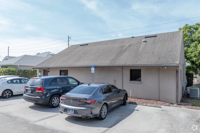
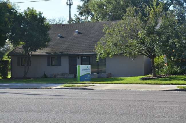
Property Record
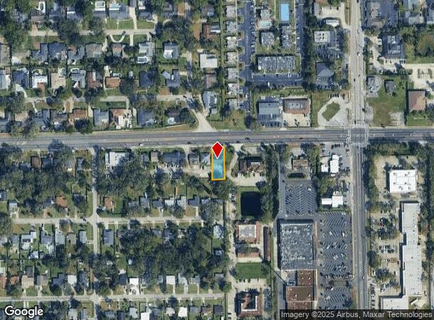
1940 Howell Branch Rd, Winter Park, FL 32792

Current Lease Availabilities
NEARBY LISTINGS FOR SALE OR LEASE
Property Detail
1940 Howell Branch Rd
Orlando-Kissimmee-Sanford, FL
Temple Terrace Annex
33-21-30-504-0F00-0010
LOT 1 BLK F (LESS RD) TEMPLE TERRACE ANNEX PB 8 PG 61
Commercialnec
Seminole
X
Florida
12095C0255F
1
2024
0.20 AC
2024
Winter Park
022201
Orlando
1,950 SF
DEMOGRAPHICS near 1940 Howell Branch Rd
1 Mile
3 Mile
5 Mile
2024 Total Population
13,632
104,423
260,502
2029 Population
14,106
108,415
270,499
Pop Growth 2024-2029
+ 3.48%
+ 3.82%
+ 3.84%
Average Age
40
41
41
2024 Total Households
6,009
44,547
111,542
HH Growth 2024-2029
+ 3.66%
+ 3.93%
+ 4.02%
Median Household Inc
$59,646
$65,969
$67,707
Avg Household Size
2.20
2.30
2.30
2024 Avg HH Vehicles
2.00
2.00
2.00
Median Home Value
$389,370
$347,079
$335,514
Median Year Built
1978
1978
1981
Nearby Places
- Restaurants
- Banks
- Shops
- Fitness
- Groceries
PUBLIC TRANSPORTATION
COMMUTER RAIL
DRIVE
WALK
Distance
7 min
3.0 mi
DRIVE
WALK
Distance
9 min
3.6 mi
AIRPORT
Orlando International
DRIVE
WALK
Distance
Orlando International
25 min
14.4 mi
Orlando Sanford International
DRIVE
WALK
Distance
Orlando Sanford International
29 min
15.1 mi
Nearby Properties
Address
Land Use
TOTAL SIZE
Lot Size
Zoning
Address
Land Use
TOTAL SIZE
Lot Size
Zoning
1,283,799 SF
51.47 AC
PQP
Address
Land Use
TOTAL SIZE
Lot Size
Zoning
712,535 SF
16.90 AC
O-1
Address
Land Use
TOTAL SIZE
Lot Size
Zoning
502,971 SF
30.54 AC
C-1
Address
Land Use
TOTAL SIZE
Lot Size
Zoning
2,416 SF
29.71 AC
Address
Land Use
TOTAL SIZE
Lot Size
Zoning
355,755 SF
50.32 AC
PQP
Address
Land Use
TOTAL SIZE
Lot Size
Zoning
676,774 SF
46.39 AC
R-4
Address
Land Use
TOTAL SIZE
Lot Size
Zoning
467,832 SF
20.10 AC
PD
Address
Land Use
TOTAL SIZE
Lot Size
Zoning
538,389 SF
3.25 AC
OC-PD
Address
Land Use
TOTAL SIZE
Lot Size
Zoning
565,620 SF
29.82 AC
R-3
Address
Land Use
TOTAL SIZE
Lot Size
Zoning
464,785 SF
2.19 AC
R-MF
Address
Land Use
TOTAL SIZE
Lot Size
Zoning
482,097 SF
2.42 AC
OC-PD
Address
Land Use
TOTAL SIZE
Lot Size
Zoning
347,890 SF
43.43 AC
IND-4
Address
Land Use
TOTAL SIZE
Lot Size
Zoning
1,158 SF
17.22 AC
Address
Land Use
TOTAL SIZE
Lot Size
Zoning
1,400 SF
31.20 AC
A1
Address
Land Use
TOTAL SIZE
Lot Size
Zoning
508,923 SF
41.05 AC
C2
Address
Land Use
TOTAL SIZE
Lot Size
Zoning
656,009 SF
5.59 AC
DM
Address
Land Use
TOTAL SIZE
Lot Size
Zoning
510,629 SF
23.08 AC
R-3
Address
Land Use
TOTAL SIZE
Lot Size
Zoning
414,790 SF
1.79 AC
RSTD R-3
Address
Land Use
TOTAL SIZE
Lot Size
Zoning
563,546 SF
0.61 AC
DM
Address
Land Use
TOTAL SIZE
Lot Size
Zoning
122,491 SF
3.35 AC
R-4
Address
Land Use
TOTAL SIZE
Lot Size
Zoning
555,833 SF
3.65 AC
DM
Address
Land Use
TOTAL SIZE
Lot Size
Zoning
505,902 SF
4.69 AC
DM
Address
Land Use
TOTAL SIZE
Lot Size
Zoning
277,160 SF
2.38 AC
R-MF
Address
Land Use
TOTAL SIZE
Lot Size
Zoning
396,016 SF
4.45 AC
R-4
Address
Land Use
TOTAL SIZE
Lot Size
Zoning
434,387 SF
26.01 AC
R3
Address
Land Use
TOTAL SIZE
Lot Size
Zoning
135,028 SF
27.59 AC
PR
Address
Land Use
TOTAL SIZE
Lot Size
Zoning
321,144 SF
3.80 AC
R-3
Address
Land Use
TOTAL SIZE
Lot Size
Zoning
29,572 SF
66.27 AC
PR
Address
Land Use
TOTAL SIZE
Lot Size
Zoning
302,513 SF
12.82 AC
R-3
Address
Land Use
TOTAL SIZE
Lot Size
Zoning
322,180 SF
14.60 AC
A1
The World's #1 Commercial Real Estate Marketplace
Connect with us
© 2025 CoStar Group
The information above has been obtained from sources believed reliable. While we do not doubt its accuracy we have not verified it and make no guarantee, warranty or representation about it. It is your responsibility to independently confirm its accuracy and completeness. Any projections, opinions, assumptions, or estimates used are for example only and do not represent the current or future performance of the property. The value of this transaction to you depends on tax and other factors which should be evaluated by your tax, financial, and legal advisors. You and your advisors should conduct a careful, independent investigation of the property to determine to your satisfaction the suitability of the property for your needs.