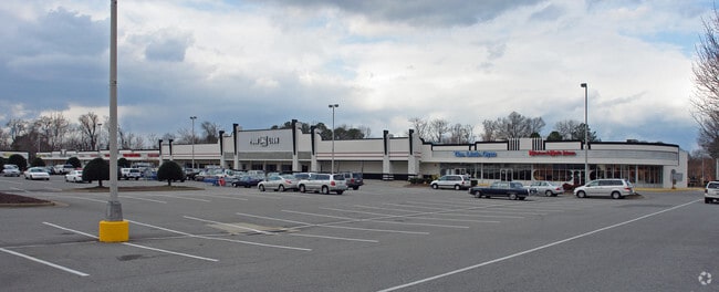
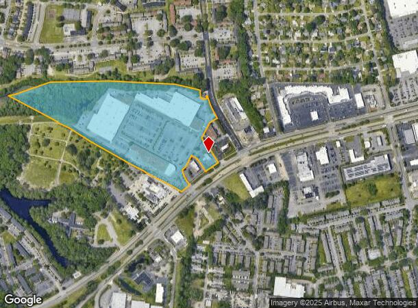
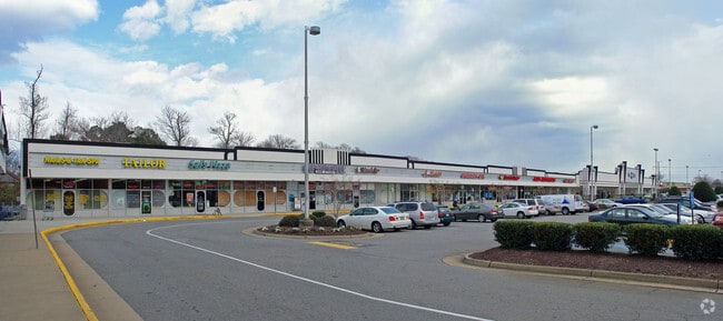
Property Record
1940 Laskin Rd, Virginia Beach, VA 23454
NEARBY LISTINGS FOR SALE OR LEASE
Property Detail
1940 Laskin Rd
2407-38-7103
Regency Hilltop Assoc
Regionalshoppingcenterormallwithanchorstore
REGENCY HILLTOP ASSOC PARCEL A-1 23.7845 AC
AE
Virginia Beach
5155310106G
Virginia
2024
23.79 AC
2025
Hilltop/Great Neck
044807
Hampton Roads
2,102 SF
Virginia Beach-Chesapeake-Norfolk, VA-NC
DEMOGRAPHICS near 1940 Laskin Rd
1 Mile
3 Mile
5 Mile
2024 Total Population
13,732
62,711
161,259
2029 Population
13,610
62,401
160,750
Pop Growth 2024-2029
(0.89%)
(0.49%)
(0.32%)
Average Age
38
40
40
2024 Total Households
6,010
27,007
66,900
HH Growth 2024-2029
(1.05%)
(0.62%)
(0.27%)
Median Household Inc
$72,790
$74,646
$79,907
Avg Household Size
2.20
2.20
2.30
2024 Avg HH Vehicles
2.00
2.00
2.00
Median Home Value
$323,474
$402,157
$365,499
Median Year Built
1978
1980
1979
Nearby Places
Map Layers
Map Styles
 Street
 Aerial
- Restaurants
- Banks
- Shops
- Fitness
- Groceries
PUBLIC TRANSPORTATION
AIRPORT
Norfolk International
DRIVE
WALK
Distance
Norfolk International
24 min
14.7 mi
Newport News/Williamsburg International
DRIVE
WALK
Distance
Newport News/Williamsburg International
59 min
40.2 mi
SALE & LEASE HISTORY
LISTING DATE
SALE/LEASE

Sep 25, 2016
For Lease
Nearby Properties
Address
Land Use
TOTAL SIZE
Lot Size
Zoning
Address
Land Use
TOTAL SIZE
Lot Size
Zoning
1,991 SF
201.95 AC
I2
Address
Land Use
TOTAL SIZE
Lot Size
Zoning
515,125 SF
24.35 AC
OR
Address
Land Use
TOTAL SIZE
Lot Size
Zoning
567,701 SF
28.93 AC
O2
Address
Land Use
TOTAL SIZE
Lot Size
Zoning
250,902 SF
21.66 AC
OR
Address
Land Use
TOTAL SIZE
Lot Size
Zoning
1 SF
25.89 AC
A18
Address
Land Use
TOTAL SIZE
Lot Size
Zoning
1 SF
26.72 AC
A18
Address
Land Use
TOTAL SIZE
Lot Size
Zoning
1 SF
30.13 AC
A18
Address
Land Use
TOTAL SIZE
Lot Size
Zoning
496,824 SF
2.26 AC
OR
Address
Land Use
TOTAL SIZE
Lot Size
Zoning
795,994 SF
52.17 AC
I1
Address
Land Use
TOTAL SIZE
Lot Size
Zoning
4 SF
23.34 AC
A36
Address
Land Use
TOTAL SIZE
Lot Size
Zoning
1 SF
9.78 AC
A24
Address
Land Use
TOTAL SIZE
Lot Size
Zoning
336,000 SF
10.99 AC
R5S
Address
Land Use
TOTAL SIZE
Lot Size
Zoning
13.17 AC
A36
Address
Land Use
TOTAL SIZE
Lot Size
Zoning
1 SF
0.02 AC
A18
Address
Land Use
TOTAL SIZE
Lot Size
Zoning
3.40 AC
OR
Address
Land Use
TOTAL SIZE
Lot Size
Zoning
1 SF
0.01 AC
A18
Address
Land Use
TOTAL SIZE
Lot Size
Zoning
499,120 SF
138.57 AC
R25
Address
Land Use
TOTAL SIZE
Lot Size
Zoning
199,051 SF
18.43 AC
B2
Address
Land Use
TOTAL SIZE
Lot Size
Zoning
269,180 SF
30.63 AC
R15
Address
Land Use
TOTAL SIZE
Lot Size
Zoning
358,274 SF
30.64 AC
B2
Address
Land Use
TOTAL SIZE
Lot Size
Zoning
4 SF
6.23 AC
A36
Address
Land Use
TOTAL SIZE
Lot Size
Zoning
1 SF
12.27 AC
A36
Address
Land Use
TOTAL SIZE
Lot Size
Zoning
1 SF
0.01 AC
A18
Address
Land Use
TOTAL SIZE
Lot Size
Zoning
133,169 SF
21.51 AC
R10
Address
Land Use
TOTAL SIZE
Lot Size
Zoning
12 SF
5.25 AC
OR
Address
Land Use
TOTAL SIZE
Lot Size
Zoning
150,339 SF
0.01 AC
B2
Address
Land Use
TOTAL SIZE
Lot Size
Zoning
168,788 SF
6.43 AC
A18
Address
Land Use
TOTAL SIZE
Lot Size
Zoning
1 SF
14.87 AC
A18
Address
Land Use
TOTAL SIZE
Lot Size
Zoning
269,352 SF
50 AC
R20
Address
Land Use
TOTAL SIZE
Lot Size
Zoning
1 SF
0.01 AC
A18
The World's #1 Commercial Real Estate Marketplace
Connect with us
© 2026 CoStar Group
The information above has been obtained from sources believed reliable. While we do not doubt its accuracy we have not verified it and make no guarantee, warranty or representation about it. It is your responsibility to independently confirm its accuracy and completeness. Any projections, opinions, assumptions, or estimates used are for example only and do not represent the current or future performance of the property. The value of this transaction to you depends on tax and other factors which should be evaluated by your tax, financial, and legal advisors. You and your advisors should conduct a careful, independent investigation of the property to determine to your satisfaction the suitability of the property for your needs.