Property Record
1940 Mcdonough Rd, Hampton, GA 30228


Save to a Folder
{{folder.Name}}
{{folder.ListingIds.length}} Properties
{{folder.ListingIds.length}} Property
Create a New Folder
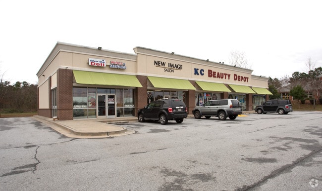
Property Detail
1940 Mcdonough Rd
06-00130-131-027
Clayton
Stripcommercialcenter
Georgia
C
131
B and X Area of moderate flood hazard, usually the area between the limits of the 100-year and 500-year floods.
0.86 AC
2025
Riverdale/Jonesboro
2025
Atlanta
040625
Atlanta-Sandy Springs-Roswell, GA
6,664 SF
NEARBY LISTINGS FOR SALE OR LEASE
DEMOGRAPHICS near 1940 Mcdonough Rd
1 mile
3 mile
5 mile
2025 Total Population
11,773
38,706
83,668
2030 Population
11,978
39,288
85,524
Pop Growth 2025-2030
+ 1.74%
+ 1.50%
+ 2.22%
Average Age
35
36
38
2025 Total Households
3,597
12,554
27,681
HH Growth 2025-2030
+ 1.22%
+ 1.45%
+ 2.20%
Median Household Inc
$66,609
$70,349
$80,829
Avg Household Size
2.80
2.90
2.90
2025 Avg HH Vehicles
2.00
2.00
2.00
Median Home Value
$271,807
$280,850
$307,568
Median Year Built
2004
2001
1999
Nearby Places
Map Layers
Map Styles
 Street
 Aerial
Layers
 Traffic
 Biking
Places
Listings with unknown addresses are not visible on the map
- Restaurants
- Banks
- Shops
- Fitness
- Groceries
PUBLIC TRANSPORTATION
AIRPORT
Hartsfield - Jackson Atlanta International
Drive
Walk
Distance
Hartsfield - Jackson Atlanta International
28 min
16.8 mi
Freight Ports
Georgia Ports - Savannah
Drive
Walk
Distance
Georgia Ports - Savannah
258 min
229.6 mi
SALE & LEASE HISTORY
LISTING DATE
SALE/LEASE

May 05, 2022
For Lease
Jun 16, 2018
For Sale
Feb 18, 2021
For Sale
Nearby Properties
Address
Land Use
TOTAL SIZE
Lot Size
Zoning
Address
Land Use
TOTAL SIZE
Lot Size
Zoning
269,130 SF
15.78 AC
C
Address
Land Use
TOTAL SIZE
Lot Size
Zoning
3,437 SF
121.60 AC
AG
Address
Land Use
TOTAL SIZE
Lot Size
Zoning
344,076 SF
69.14 AC
AG
Address
Land Use
TOTAL SIZE
Lot Size
Zoning
250 SF
23.09 AC
C
Address
Land Use
TOTAL SIZE
Lot Size
Zoning
240 SF
30 AC
RM
Address
Land Use
TOTAL SIZE
Lot Size
Zoning
72,253 SF
50 AC
ER
Address
Land Use
TOTAL SIZE
Lot Size
Zoning
224 SF
20 AC
C
Address
Land Use
TOTAL SIZE
Lot Size
Zoning
194,270 SF
24.27 AC
C
Address
Land Use
TOTAL SIZE
Lot Size
Zoning
21.01 AC
C
Address
Land Use
TOTAL SIZE
Lot Size
Zoning
18,990 SF
13.11 AC
C
Address
Land Use
TOTAL SIZE
Lot Size
Zoning
5,529 SF
26.29 AC
OI
Address
Land Use
TOTAL SIZE
Lot Size
Zoning
69,505 SF
10.68 AC
GB
Address
Land Use
TOTAL SIZE
Lot Size
Zoning
54,499 SF
10.18 AC
GB
Address
Land Use
TOTAL SIZE
Lot Size
Zoning
55,650 SF
19.71 AC
AG
Address
Land Use
TOTAL SIZE
Lot Size
Zoning
116,822 SF
4.10 AC
RS180
Address
Land Use
TOTAL SIZE
Lot Size
Zoning
42,762 SF
6 AC
C
Address
Land Use
TOTAL SIZE
Lot Size
Zoning
289 SF
50.20 AC
C
Address
Land Use
TOTAL SIZE
Lot Size
Zoning
102,653 SF
5.50 AC
ER
Address
Land Use
TOTAL SIZE
Lot Size
Zoning
34,563 SF
4.88 AC
C
Address
Land Use
TOTAL SIZE
Lot Size
Zoning
19.35 AC
ER
Address
Land Use
TOTAL SIZE
Lot Size
Zoning
26,297 SF
77 AC
AG
Address
Land Use
TOTAL SIZE
Lot Size
Zoning
47,057 SF
6.83 AC
C
Address
Land Use
TOTAL SIZE
Lot Size
Zoning
9.19 AC
C
Address
Land Use
TOTAL SIZE
Lot Size
Zoning
29,786 SF
15.41 AC
GB
Address
Land Use
TOTAL SIZE
Lot Size
Zoning
1,826 SF
169.71 AC
C
Address
Land Use
TOTAL SIZE
Lot Size
Zoning
3,648 SF
533.15 AC
AG
Address
Land Use
TOTAL SIZE
Lot Size
Zoning
8.44 AC
C
Address
Land Use
TOTAL SIZE
Lot Size
Zoning
12,400 SF
4.24 AC
MXI
Address
Land Use
TOTAL SIZE
Lot Size
Zoning
611 SF
155.70 AC
RMH
Address
Land Use
TOTAL SIZE
Lot Size
Zoning
1,750 SF
5.13 AC
GB
The World's #1 Commercial Real Estate Marketplace
Connect with us
© 2026 CoStar Group
The information above has been obtained from sources believed reliable. While we do not doubt its accuracy we have not verified it and make no guarantee, warranty or representation about it. It is your responsibility to independently confirm its accuracy and completeness. Any projections, opinions, assumptions, or estimates used are for example only and do not represent the current or future performance of the property. The value of this transaction to you depends on tax and other factors which should be evaluated by your tax, financial, and legal advisors. You and your advisors should conduct a careful, independent investigation of the property to determine to your satisfaction the suitability of the property for your needs.