Property Record
1940 N Christensen Rd, Coolidge, AZ 85128
Property Detail
1940 N Christensen Rd
401-21-088B
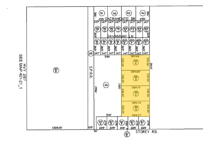
COMM @ S1/4 COR OF SEC 15-6S-8E TH N-275 TO POB TH W-589.77 TH N- 330.31 TH E-589.74 TH S-330.35 TO POB 4.47 AC
Vacantlandnec
PINAL
CI2
Arizona
B and X Area of moderate flood hazard, usually the area between the limits of the 100-year and 500-year floods.
4.47 AC
2024
Pinal County
2025
Phoenix
001100
Phoenix-Mesa-Chandler, AZ
NEARBY LISTINGS FOR SALE OR LEASE
-
-
View all Coolidge listings for sale on LoopNet.com
DEMOGRAPHICS near 1940 N Christensen Rd
1 mile
3 mile
5 mile
2025 Total Population
75
1,258
5,808
2030 Population
90
1,503
6,885
Pop Growth 2025-2030
+ 20.00%
+ 19.48%
+ 18.54%
Average Age
46
46
42
2025 Total Households
31
511
2,189
HH Growth 2025-2030
+ 19.35%
+ 19.57%
+ 18.55%
Median Household Inc
$57,499
$50,185
$53,861
Avg Household Size
2.50
2.40
2.60
2025 Avg HH Vehicles
2.00
2.00
2.00
Median Home Value
$162,499
$176,119
$168,623
Median Year Built
1994
1995
1993
Nearby Places
Map Layers
Map Styles
 Street
 Aerial
Layers
 Traffic
 Biking
Places
Listings with unknown addresses are not visible on the map
- Restaurants
- Banks
- Shops
- Fitness
- Groceries
PUBLIC TRANSPORTATION
AIRPORT
Phoenix-Mesa Gateway
Drive
Walk
Distance
Phoenix-Mesa Gateway
63 min
37.5 mi
Freight Ports
Port of San Diego
Drive
Walk
Distance
Port of San Diego
393 min
364.1 mi
Nearby Properties
Address
Land Use
TOTAL SIZE
Lot Size
Zoning
Address
Land Use
TOTAL SIZE
Lot Size
Zoning
73,320 SF
33.83 AC
Address
Land Use
TOTAL SIZE
Lot Size
Zoning
8,594 SF
37.10 AC
UNDESIGNAT
Address
Land Use
TOTAL SIZE
Lot Size
Zoning
125.72 AC
Address
Land Use
TOTAL SIZE
Lot Size
Zoning
41,042 SF
77.11 AC
UNDESIGNAT
Address
Land Use
TOTAL SIZE
Lot Size
Zoning
3,772 SF
50 AC
Address
Land Use
TOTAL SIZE
Lot Size
Zoning
120.50 AC
UNDESIGNAT
Address
Land Use
TOTAL SIZE
Lot Size
Zoning
100.87 AC
UNDESIGNAT
Address
Land Use
TOTAL SIZE
Lot Size
Zoning
8,872 SF
105 AC
GR
Address
Land Use
TOTAL SIZE
Lot Size
Zoning
60.69 AC
GR
Address
Land Use
TOTAL SIZE
Lot Size
Zoning
72.54 AC
GR
Address
Land Use
TOTAL SIZE
Lot Size
Zoning
Address
Land Use
TOTAL SIZE
Lot Size
Zoning
59.07 AC
Address
Land Use
TOTAL SIZE
Lot Size
Zoning
49.27 AC
UNDESIGNAT
Address
Land Use
TOTAL SIZE
Lot Size
Zoning
1,200 SF
40 AC
Address
Land Use
TOTAL SIZE
Lot Size
Zoning
44.88 AC
UNDESIGNAT
Address
Land Use
TOTAL SIZE
Lot Size
Zoning
44.49 AC
UNDESIGNAT
The World's #1 Commercial Real Estate Marketplace
Connect with us
© 2026 CoStar Group
The information above has been obtained from sources believed reliable. While we do not doubt its accuracy we have not verified it and make no guarantee, warranty or representation about it. It is your responsibility to independently confirm its accuracy and completeness. Any projections, opinions, assumptions, or estimates used are for example only and do not represent the current or future performance of the property. The value of this transaction to you depends on tax and other factors which should be evaluated by your tax, financial, and legal advisors. You and your advisors should conduct a careful, independent investigation of the property to determine to your satisfaction the suitability of the property for your needs.