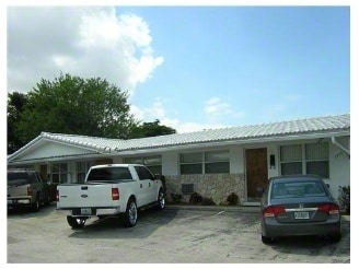
Property Record
1940 Ne 31St St, Lighthouse Point, FL 33064
NEARBY LISTINGS FOR SALE OR LEASE
Property Detail
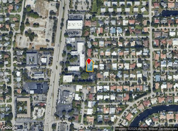
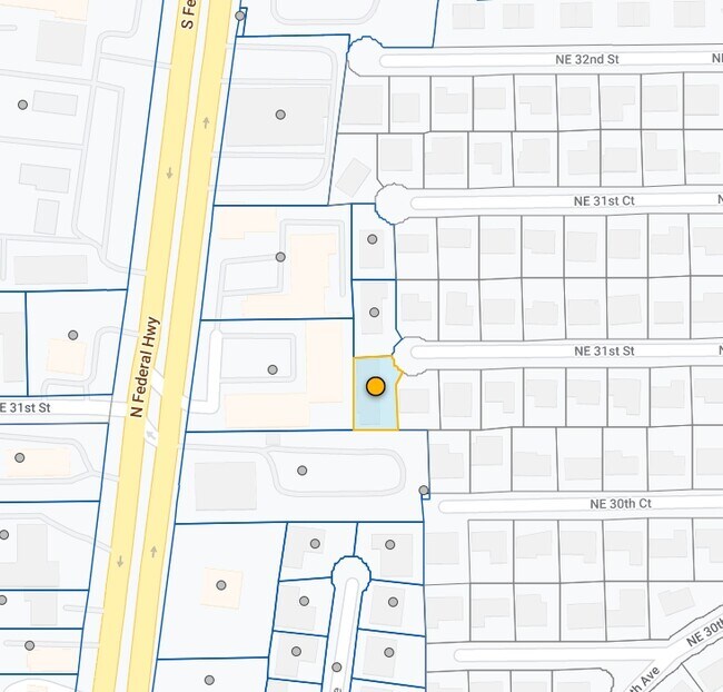
1940 Ne 31St St
Fort Lauderdale-Pompano Beach-Deerfield Beach, FL
Douglas Park
48-43-19-17-0240
DOUGLAS PARK 45-29 B LOT 16 BLK 2
Quadruplex
Broward
AE
Florida
12011C0188J
16
2024
0.23 AC
2025
Outer Pompano Beach/Deerfield Beach
030100
South Florida
3,621 SF
DEMOGRAPHICS near 1940 Ne 31St St
1 Mile
3 Mile
5 Mile
2024 Total Population
16,362
115,499
244,735
2029 Population
16,206
116,144
248,775
Pop Growth 2024-2029
(0.95%)
+ 0.56%
+ 1.65%
Average Age
43
43
46
2024 Total Households
6,763
48,362
109,534
HH Growth 2024-2029
(1.24%)
+ 0.68%
+ 1.98%
Median Household Inc
$71,465
$59,025
$58,631
Avg Household Size
2.30
2.30
2.10
2024 Avg HH Vehicles
2.00
2.00
1.00
Median Home Value
$367,411
$354,878
$345,439
Median Year Built
1964
1973
1975
Nearby Places
Map Layers
Map Styles
 Street
 Aerial
- Restaurants
- Banks
- Shops
- Fitness
- Groceries
PUBLIC TRANSPORTATION
COMMUTER RAIL
Pompano Beach (Tri-County Commuter - South Florida Regional Transportation Authority (Tri-Rail))
DRIVE
WALK
Distance
Pompano Beach (Tri-County Commuter - South Florida Regional Transportation Authority (Tri-Rail))
9 min
3.5 mi
Deerfield Beach (Tri-County Commuter - South Florida Regional Transportation Authority (Tri-Rail))
DRIVE
WALK
Distance
Deerfield Beach (Tri-County Commuter - South Florida Regional Transportation Authority (Tri-Rail))
14 min
6.6 mi
AIRPORT
Fort Lauderdale/Hollywood International
DRIVE
WALK
Distance
Fort Lauderdale/Hollywood International
30 min
19.8 mi
Palm Beach International
DRIVE
WALK
Distance
Palm Beach International
46 min
34.0 mi
Miami International
DRIVE
WALK
Distance
Miami International
67 min
45.0 mi
Freight Ports
Port Everglades
DRIVE
WALK
Distance
Port Everglades
28 min
18.9 mi
Nearby Properties
Address
Land Use
TOTAL SIZE
Lot Size
Zoning
Address
Land Use
TOTAL SIZE
Lot Size
Zoning
696,020 SF
31.74 AC
OPC
Address
Land Use
TOTAL SIZE
Lot Size
Zoning
513,748 SF
2.99 AC
TO-EOD
Address
Land Use
TOTAL SIZE
Lot Size
Zoning
484,380 SF
137.82 AC
T
Address
Land Use
TOTAL SIZE
Lot Size
Zoning
285,335 SF
8.56 AC
RM-45
Address
Land Use
TOTAL SIZE
Lot Size
Zoning
184,184 SF
2.98 AC
RM-45/HR
Address
Land Use
TOTAL SIZE
Lot Size
Zoning
392,222 SF
5.33 AC
RPUD
Address
Land Use
TOTAL SIZE
Lot Size
Zoning
406,839 SF
1.61 AC
RPUD
Address
Land Use
TOTAL SIZE
Lot Size
Zoning
161,512 SF
16.39 AC
RPC
Address
Land Use
TOTAL SIZE
Lot Size
Zoning
434,859 SF
38.72 AC
CF
Address
Land Use
TOTAL SIZE
Lot Size
Zoning
399,854 SF
1.60 AC
TO-EOD
Address
Land Use
TOTAL SIZE
Lot Size
Zoning
386,427 SF
2.24 AC
RM-25
Address
Land Use
TOTAL SIZE
Lot Size
Zoning
374,776 SF
23.52 AC
I-1
Address
Land Use
TOTAL SIZE
Lot Size
Zoning
435,201 SF
23.78 AC
I-1
Address
Land Use
TOTAL SIZE
Lot Size
Zoning
313,030 SF
37.22 AC
CF
Address
Land Use
TOTAL SIZE
Lot Size
Zoning
192,214 SF
10.84 AC
B-3/PCD
Address
Land Use
TOTAL SIZE
Lot Size
Zoning
171,306 SF
0.81 AC
TO-EOD
Address
Land Use
TOTAL SIZE
Lot Size
Zoning
244,452 SF
13.10 AC
RM-20
Address
Land Use
TOTAL SIZE
Lot Size
Zoning
260,464 SF
14.82 AC
PUD
Address
Land Use
TOTAL SIZE
Lot Size
Zoning
252,763 SF
17.03 AC
PUD
Address
Land Use
TOTAL SIZE
Lot Size
Zoning
222,660 SF
18.22 AC
CF
Address
Land Use
TOTAL SIZE
Lot Size
Zoning
152,273 SF
20.03 AC
B-3
Address
Land Use
TOTAL SIZE
Lot Size
Zoning
144,205 SF
5 AC
RM-25
Address
Land Use
TOTAL SIZE
Lot Size
Zoning
197,145 SF
13.71 AC
PUD
Address
Land Use
TOTAL SIZE
Lot Size
Zoning
315,368 SF
25.22 AC
I-1
Address
Land Use
TOTAL SIZE
Lot Size
Zoning
25,003 SF
34.83 AC
PR
Address
Land Use
TOTAL SIZE
Lot Size
Zoning
194,821 SF
19.18 AC
PUD
Address
Land Use
TOTAL SIZE
Lot Size
Zoning
139,746 SF
17.86 AC
B-3
Address
Land Use
TOTAL SIZE
Lot Size
Zoning
49,409 SF
70.79 AC
CF
Address
Land Use
TOTAL SIZE
Lot Size
Zoning
115,200 SF
1.18 AC
RM-45
Address
Land Use
TOTAL SIZE
Lot Size
Zoning
248,682 SF
15.10 AC
I-1/PCD
The World's #1 Commercial Real Estate Marketplace
Connect with us
© 2025 CoStar Group
The information above has been obtained from sources believed reliable. While we do not doubt its accuracy we have not verified it and make no guarantee, warranty or representation about it. It is your responsibility to independently confirm its accuracy and completeness. Any projections, opinions, assumptions, or estimates used are for example only and do not represent the current or future performance of the property. The value of this transaction to you depends on tax and other factors which should be evaluated by your tax, financial, and legal advisors. You and your advisors should conduct a careful, independent investigation of the property to determine to your satisfaction the suitability of the property for your needs.