Property Record
1940 Route 611, Swiftwater, PA 18370
NEARBY LISTINGS FOR SALE OR LEASE
-
-
View all Swiftwater listings for sale on LoopNet.com
Property Detail
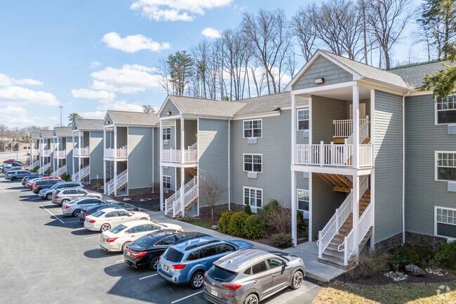
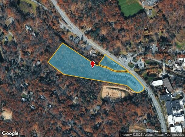
1940 Route 611
East Stroudsburg, PA
Swiftwater Inn Est 1778
12.12.2.8
LOT 1
Apartment
Monroe
AE
Pennsylvania
42089C0252E
1
2025
17.79 AC
2025
Monroe County
300401
Philadelphia
40,320 SF
DEMOGRAPHICS near 1940 Route 611
1 Mile
3 Mile
5 Mile
2024 Total Population
823
7,361
23,767
2029 Population
797
7,278
23,594
Pop Growth 2024-2029
(3.16%)
(1.13%)
(0.73%)
Average Age
46
44
43
2024 Total Households
345
3,020
9,006
HH Growth 2024-2029
(2.90%)
(1.13%)
(0.78%)
Median Household Inc
$89,999
$90,644
$82,219
Avg Household Size
2.40
2.40
2.60
2024 Avg HH Vehicles
2.00
2.00
2.00
Median Home Value
$224,475
$225,890
$208,586
Median Year Built
1978
1981
1985
Nearby Places
Map Layers
Map Styles
 Street
 Aerial
- Restaurants
- Banks
- Shops
- Fitness
- Groceries
PUBLIC TRANSPORTATION
AIRPORT
Wilkes-Barre/Scranton International
DRIVE
WALK
Distance
Wilkes-Barre/Scranton International
51 min
38.8 mi
Freight Ports
Maher Terminal
DRIVE
WALK
Distance
Maher Terminal
105 min
82.4 mi
Nearby Properties
Address
Land Use
TOTAL SIZE
Lot Size
Zoning
Address
Land Use
TOTAL SIZE
Lot Size
Zoning
463,854 SF
95.86 AC
C
Address
Land Use
TOTAL SIZE
Lot Size
Zoning
1,132 SF
212.87 AC
I
Address
Land Use
TOTAL SIZE
Lot Size
Zoning
627,114 SF
896.17 AC
R-2
Address
Land Use
TOTAL SIZE
Lot Size
Zoning
11,060 SF
156.57 AC
R-2
Address
Land Use
TOTAL SIZE
Lot Size
Zoning
1,177,560 SF
77.25 AC
C-2
Address
Land Use
TOTAL SIZE
Lot Size
Zoning
133,288 SF
43.10 AC
R-2
Address
Land Use
TOTAL SIZE
Lot Size
Zoning
88,444 SF
19.57 AC
C-2
Address
Land Use
TOTAL SIZE
Lot Size
Zoning
86,290 SF
6.15 AC
C-2
Address
Land Use
TOTAL SIZE
Lot Size
Zoning
6,710 SF
5.18 AC
C-2
Address
Land Use
TOTAL SIZE
Lot Size
Zoning
6,164 SF
597.02 AC
RD
Address
Land Use
TOTAL SIZE
Lot Size
Zoning
37,948 SF
47.53 AC
RR
Address
Land Use
TOTAL SIZE
Lot Size
Zoning
78,842 SF
7.24 AC
RD
Address
Land Use
TOTAL SIZE
Lot Size
Zoning
27,614 SF
36.14 AC
C
Address
Land Use
TOTAL SIZE
Lot Size
Zoning
1.32 AC
RD
Address
Land Use
TOTAL SIZE
Lot Size
Zoning
5,952 SF
21.50 AC
C
Address
Land Use
TOTAL SIZE
Lot Size
Zoning
4,696 SF
130.12 AC
B-1
Address
Land Use
TOTAL SIZE
Lot Size
Zoning
1,212 SF
1 AC
C
Address
Land Use
TOTAL SIZE
Lot Size
Zoning
238.65 AC
R-3
Address
Land Use
TOTAL SIZE
Lot Size
Zoning
17,217 SF
6.67 AC
R-1
Address
Land Use
TOTAL SIZE
Lot Size
Zoning
26,603 SF
1.53 AC
C-2
Address
Land Use
TOTAL SIZE
Lot Size
Zoning
9,280 SF
0.34 AC
C-2
Address
Land Use
TOTAL SIZE
Lot Size
Zoning
5,084 SF
1.90 AC
C-2
Address
Land Use
TOTAL SIZE
Lot Size
Zoning
14,502 SF
2.03 AC
C-2
Address
Land Use
TOTAL SIZE
Lot Size
Zoning
11,720 SF
0.10 AC
RD
Address
Land Use
TOTAL SIZE
Lot Size
Zoning
5,812 SF
1.45 AC
C-2
Address
Land Use
TOTAL SIZE
Lot Size
Zoning
2,732 SF
7.86 AC
C-2
Address
Land Use
TOTAL SIZE
Lot Size
Zoning
12,052 SF
4.20 AC
C
Address
Land Use
TOTAL SIZE
Lot Size
Zoning
30,447 SF
111.66 AC
R-1
Address
Land Use
TOTAL SIZE
Lot Size
Zoning
12,945 SF
6.71 AC
C
The World's #1 Commercial Real Estate Marketplace
Connect with us
© 2025 CoStar Group
The information above has been obtained from sources believed reliable. While we do not doubt its accuracy we have not verified it and make no guarantee, warranty or representation about it. It is your responsibility to independently confirm its accuracy and completeness. Any projections, opinions, assumptions, or estimates used are for example only and do not represent the current or future performance of the property. The value of this transaction to you depends on tax and other factors which should be evaluated by your tax, financial, and legal advisors. You and your advisors should conduct a careful, independent investigation of the property to determine to your satisfaction the suitability of the property for your needs.