Property Record
19401 Tamarack St Nw, Cedar, MN 55011
NEARBY LISTINGS FOR SALE OR LEASE
-
-
View all Cedar listings for sale on LoopNet.com
Property Detail
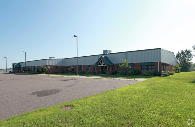
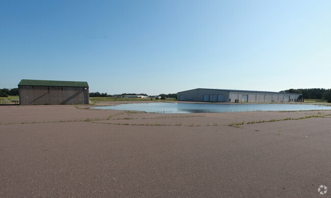
19401 Tamarack St Nw
26-33-24-14-0002
Parcel 1:That part of the Southeast Quarter of the Northeast Quarter of Section 26, Township 33, Ran
Industrialgeneral
Anoka
X
Minnesota
27003C0183E
27.20 AC
2024
North Central
2025
Minneapolis/St Paul
050115
Minneapolis-St. Paul-Bloomington, MN-WI
50,500 SF
DEMOGRAPHICS near 19401 Tamarack St Nw
1 Mile
3 Mile
5 Mile
2024 Total Population
521
7,386
28,443
2029 Population
545
7,723
29,632
Pop Growth 2024-2029
+ 4.61%
+ 4.56%
+ 4.18%
Average Age
43
42
40
2024 Total Households
180
2,602
9,772
HH Growth 2024-2029
+ 5.00%
+ 4.57%
+ 4.22%
Median Household Inc
$113,392
$116,579
$113,714
Avg Household Size
2.90
2.80
2.90
2024 Avg HH Vehicles
3.00
3.00
3.00
Median Home Value
$372,972
$363,803
$369,815
Median Year Built
1981
1987
1991
Nearby Places
Map Layers
Map Styles
 Street
 Aerial
- Restaurants
- Banks
- Shops
- Fitness
- Groceries
SALE & LEASE HISTORY
LISTING DATE
SALE/LEASE

Sep 25, 2016
For Lease
Nov 17, 2016
For Sale
Nearby Properties
Address
Land Use
TOTAL SIZE
Lot Size
Zoning
Address
Land Use
TOTAL SIZE
Lot Size
Zoning
5.98 AC
Address
Land Use
TOTAL SIZE
Lot Size
Zoning
63,671 SF
40 AC
Address
Land Use
TOTAL SIZE
Lot Size
Zoning
Address
Land Use
TOTAL SIZE
Lot Size
Zoning
102,360 SF
6.06 AC
Address
Land Use
TOTAL SIZE
Lot Size
Zoning
1,130 SF
10 AC
Address
Land Use
TOTAL SIZE
Lot Size
Zoning
14,742 SF
34.67 AC
Address
Land Use
TOTAL SIZE
Lot Size
Zoning
22,185 SF
Address
Land Use
TOTAL SIZE
Lot Size
Zoning
22,656 SF
12.10 AC
Address
Land Use
TOTAL SIZE
Lot Size
Zoning
22,292 SF
5.40 AC
Address
Land Use
TOTAL SIZE
Lot Size
Zoning
5,290 SF
2.80 AC
Address
Land Use
TOTAL SIZE
Lot Size
Zoning
22,400 SF
5.60 AC
Address
Land Use
TOTAL SIZE
Lot Size
Zoning
6,883 SF
2.63 AC
Address
Land Use
TOTAL SIZE
Lot Size
Zoning
14,580 SF
33.19 AC
Address
Land Use
TOTAL SIZE
Lot Size
Zoning
33,605 SF
4.33 AC
Address
Land Use
TOTAL SIZE
Lot Size
Zoning
13,284 SF
2.15 AC
Address
Land Use
TOTAL SIZE
Lot Size
Zoning
11,094 SF
10.04 AC
Address
Land Use
TOTAL SIZE
Lot Size
Zoning
25,936 SF
24.35 AC
Address
Land Use
TOTAL SIZE
Lot Size
Zoning
2.48 AC
Address
Land Use
TOTAL SIZE
Lot Size
Zoning
6,911 SF
3.21 AC
Address
Land Use
TOTAL SIZE
Lot Size
Zoning
11,078 SF
5.85 AC
Address
Land Use
TOTAL SIZE
Lot Size
Zoning
9,733 SF
8.95 AC
Address
Land Use
TOTAL SIZE
Lot Size
Zoning
13,350 SF
2.16 AC
Address
Land Use
TOTAL SIZE
Lot Size
Zoning
10,716 SF
10.03 AC
Address
Land Use
TOTAL SIZE
Lot Size
Zoning
Address
Land Use
TOTAL SIZE
Lot Size
Zoning
20,495 SF
4.64 AC
Address
Land Use
TOTAL SIZE
Lot Size
Zoning
10,600 SF
2.02 AC
Address
Land Use
TOTAL SIZE
Lot Size
Zoning
8,736 SF
2.09 AC
Address
Land Use
TOTAL SIZE
Lot Size
Zoning
19,741 SF
4.99 AC
The World's #1 Commercial Real Estate Marketplace
Connect with us
© 2026 CoStar Group
The information above has been obtained from sources believed reliable. While we do not doubt its accuracy we have not verified it and make no guarantee, warranty or representation about it. It is your responsibility to independently confirm its accuracy and completeness. Any projections, opinions, assumptions, or estimates used are for example only and do not represent the current or future performance of the property. The value of this transaction to you depends on tax and other factors which should be evaluated by your tax, financial, and legal advisors. You and your advisors should conduct a careful, independent investigation of the property to determine to your satisfaction the suitability of the property for your needs.