Property Record
1941 Haw River Hopedale Rd, Burlington, NC 27217
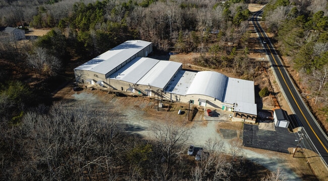

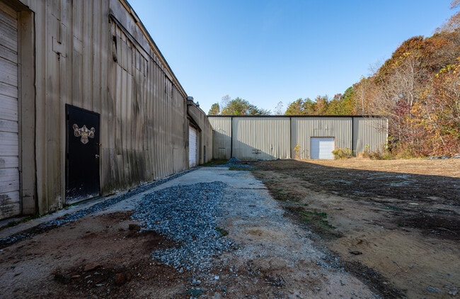
This Property Is For Sale
NEARBY LISTINGS FOR SALE OR LEASE
Property Detail
1941 Haw River Hopedale Rd
Burlington, NC
Stephen Elray Riggan Subdivision
149618
HAW RIVER HOPEDALE RD LT 1 13-17-66
Manufacturinglight
Alamance
AE
North Carolina
3710888500K
1
2025
4.32 AC
2025
N Central Alamance County
021201
Greensboro/Winston-Salem
45,400 SF
DEMOGRAPHICS near 1941 Haw River Hopedale Rd
1 Mile
3 Mile
5 Mile
2024 Total Population
2,314
33,420
74,401
2029 Population
2,490
36,373
80,568
Pop Growth 2024-2029
+ 7.61%
+ 8.84%
+ 8.29%
Average Age
39
38
39
2024 Total Households
848
13,163
29,963
HH Growth 2024-2029
+ 7.90%
+ 9.08%
+ 8.47%
Median Household Inc
$59,848
$40,657
$46,795
Avg Household Size
2.70
2.50
2.40
2024 Avg HH Vehicles
2.00
2.00
2.00
Median Home Value
$78,058
$110,047
$149,636
Median Year Built
1970
1973
1975
Nearby Places
Map Layers
Map Styles
 Street
 Aerial
- Restaurants
- Banks
- Shops
- Fitness
- Groceries
PUBLIC TRANSPORTATION
COMMUTER RAIL
Burlington Station (Piedmont - North Carolina by Train (NC Train))
DRIVE
WALK
Distance
Burlington Station (Piedmont - North Carolina by Train (NC Train))
13 min
5.8 mi
Freight Ports
Virginia Port Authority - Richmond
DRIVE
WALK
Distance
Virginia Port Authority - Richmond
205 min
175.2 mi
Nearby Properties
Address
Land Use
TOTAL SIZE
Lot Size
Zoning
Address
Land Use
TOTAL SIZE
Lot Size
Zoning
159,629 SF
82.81 AC
Address
Land Use
TOTAL SIZE
Lot Size
Zoning
27,803 SF
13.10 AC
B 2
Address
Land Use
TOTAL SIZE
Lot Size
Zoning
578,100 SF
55.30 AC
Address
Land Use
TOTAL SIZE
Lot Size
Zoning
48,136 SF
14.57 AC
B 2
Address
Land Use
TOTAL SIZE
Lot Size
Zoning
37,502 SF
17.48 AC
CR
Address
Land Use
TOTAL SIZE
Lot Size
Zoning
27,803 SF
11.53 AC
Address
Land Use
TOTAL SIZE
Lot Size
Zoning
33,280 SF
9.07 AC
I2
Address
Land Use
TOTAL SIZE
Lot Size
Zoning
40,220 SF
12.45 AC
MF A
Address
Land Use
TOTAL SIZE
Lot Size
Zoning
72,164 SF
73.50 AC
Address
Land Use
TOTAL SIZE
Lot Size
Zoning
51,994 SF
42.20 AC
OI
Address
Land Use
TOTAL SIZE
Lot Size
Zoning
71,962 SF
5.98 AC
O I
Address
Land Use
TOTAL SIZE
Lot Size
Zoning
216,968 SF
25.50 AC
CB
Address
Land Use
TOTAL SIZE
Lot Size
Zoning
23,268 SF
6.11 AC
Address
Land Use
TOTAL SIZE
Lot Size
Zoning
36,000 SF
4.43 AC
Address
Land Use
TOTAL SIZE
Lot Size
Zoning
2,923 SF
10.13 AC
Address
Land Use
TOTAL SIZE
Lot Size
Zoning
158,339 SF
16.34 AC
Address
Land Use
TOTAL SIZE
Lot Size
Zoning
22,301 SF
19.25 AC
OI
Address
Land Use
TOTAL SIZE
Lot Size
Zoning
45,321 SF
31 AC
R 12
Address
Land Use
TOTAL SIZE
Lot Size
Zoning
27,336 SF
10.84 AC
R 6
Address
Land Use
TOTAL SIZE
Lot Size
Zoning
8,312 SF
10.41 AC
Address
Land Use
TOTAL SIZE
Lot Size
Zoning
43,170 SF
6.80 AC
O I
Address
Land Use
TOTAL SIZE
Lot Size
Zoning
41,787 SF
8.07 AC
COI
Address
Land Use
TOTAL SIZE
Lot Size
Zoning
25,200 SF
5.30 AC
Address
Land Use
TOTAL SIZE
Lot Size
Zoning
8,970 SF
11.57 AC
I&C
Address
Land Use
TOTAL SIZE
Lot Size
Zoning
27,076 SF
10 AC
R 9
Address
Land Use
TOTAL SIZE
Lot Size
Zoning
81,675 SF
21.18 AC
I 2
Address
Land Use
TOTAL SIZE
Lot Size
Zoning
13,968 SF
10.04 AC
R 18
Address
Land Use
TOTAL SIZE
Lot Size
Zoning
50,549 SF
4.33 AC
OI
Address
Land Use
TOTAL SIZE
Lot Size
Zoning
213,665 SF
53.52 AC
I 2
Address
Land Use
TOTAL SIZE
Lot Size
Zoning
53,740 SF
30.43 AC
I 3
The World's #1 Commercial Real Estate Marketplace
Connect with us
© 2026 CoStar Group
The information above has been obtained from sources believed reliable. While we do not doubt its accuracy we have not verified it and make no guarantee, warranty or representation about it. It is your responsibility to independently confirm its accuracy and completeness. Any projections, opinions, assumptions, or estimates used are for example only and do not represent the current or future performance of the property. The value of this transaction to you depends on tax and other factors which should be evaluated by your tax, financial, and legal advisors. You and your advisors should conduct a careful, independent investigation of the property to determine to your satisfaction the suitability of the property for your needs.