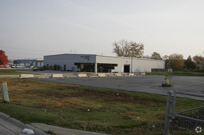
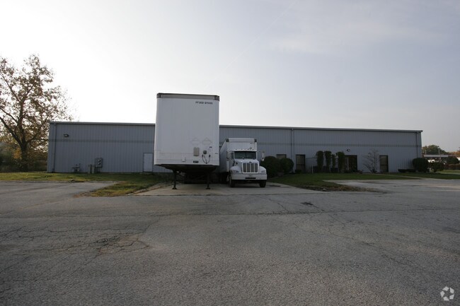
Property Record
1941 N Woodlawn Ave, Griffith, IN 46319

NEARBY LISTINGS FOR SALE OR LEASE
Property Detail
1941 N Woodlawn Ave
Chicago-Naperville-Elgin, IL-IN-WI
Brants Business Center Add
45-07-23-302-002.000-006
BRANTS BUSINESS CENTER ADD BLOCK 1 LOT 4 (1941 WOODLAWN AVE)
Warehouse
Lake
X
Indiana
18089C0141F
4
2024
1.98 AC
2025
Indiana
041001
Chicago
18,118 SF
DEMOGRAPHICS near 1941 N Woodlawn Ave
1 Mile
3 Mile
5 Mile
2024 Total Population
8,367
67,632
173,212
2029 Population
8,265
67,470
173,982
Pop Growth 2024-2029
(1.22%)
(0.24%)
+ 0.44%
Average Age
39
40
40
2024 Total Households
3,462
27,408
69,481
HH Growth 2024-2029
(1.27%)
(0.30%)
+ 0.41%
Median Household Inc
$62,740
$61,082
$57,592
Avg Household Size
2.40
2.40
2.40
2024 Avg HH Vehicles
2.00
2.00
2.00
Median Home Value
$183,969
$173,937
$175,171
Median Year Built
1967
1963
1962
Nearby Places
Map Layers
Map Styles
 Street
 Aerial
- Restaurants
- Banks
- Shops
- Fitness
- Groceries
PUBLIC TRANSPORTATION
COMMUTER RAIL
Clark Road (Gary) Station (South Shore Line - Northern Indiana Commuter Transportation District (South Shore Line))
DRIVE
WALK
Distance
Clark Road (Gary) Station (South Shore Line - Northern Indiana Commuter Transportation District (South Shore Line))
10 min
5.6 mi
DRIVE
WALK
Distance
18 min
7.5 mi
AIRPORT
Chicago Midway International
DRIVE
WALK
Distance
Chicago Midway International
45 min
29.8 mi
Nearby Properties
Address
Land Use
TOTAL SIZE
Lot Size
Zoning
Address
Land Use
TOTAL SIZE
Lot Size
Zoning
233,023 SF
37.73 AC
Address
Land Use
TOTAL SIZE
Lot Size
Zoning
233,767 SF
37.03 AC
Address
Land Use
TOTAL SIZE
Lot Size
Zoning
133,120 SF
32.04 AC
Address
Land Use
TOTAL SIZE
Lot Size
Zoning
394,442 SF
16.83 AC
Address
Land Use
TOTAL SIZE
Lot Size
Zoning
214,752 SF
10.41 AC
R3
Address
Land Use
TOTAL SIZE
Lot Size
Zoning
153,073 SF
4.88 AC
Address
Land Use
TOTAL SIZE
Lot Size
Zoning
80,444 SF
13.41 AC
R3
Address
Land Use
TOTAL SIZE
Lot Size
Zoning
77,091 SF
2.08 AC
Address
Land Use
TOTAL SIZE
Lot Size
Zoning
233,769 SF
29.04 AC
R3
Address
Land Use
TOTAL SIZE
Lot Size
Zoning
217,104 SF
10.45 AC
Address
Land Use
TOTAL SIZE
Lot Size
Zoning
79,169 SF
2.76 AC
Address
Land Use
TOTAL SIZE
Lot Size
Zoning
105,000 SF
2.90 AC
Address
Land Use
TOTAL SIZE
Lot Size
Zoning
189,392 SF
23.77 AC
Address
Land Use
TOTAL SIZE
Lot Size
Zoning
34,116 SF
73.40 AC
Address
Land Use
TOTAL SIZE
Lot Size
Zoning
79,059 SF
7.07 AC
R3
Address
Land Use
TOTAL SIZE
Lot Size
Zoning
100,000 SF
7.29 AC
R3
Address
Land Use
TOTAL SIZE
Lot Size
Zoning
167,108 SF
10.18 AC
Address
Land Use
TOTAL SIZE
Lot Size
Zoning
69,576 SF
2.55 AC
Address
Land Use
TOTAL SIZE
Lot Size
Zoning
53,096 SF
8.64 AC
R3
Address
Land Use
TOTAL SIZE
Lot Size
Zoning
60,234 SF
9.01 AC
Address
Land Use
TOTAL SIZE
Lot Size
Zoning
33,920 SF
83.34 AC
Address
Land Use
TOTAL SIZE
Lot Size
Zoning
55,656 SF
1.99 AC
R3
Address
Land Use
TOTAL SIZE
Lot Size
Zoning
112,758 SF
8.02 AC
Address
Land Use
TOTAL SIZE
Lot Size
Zoning
74,229 SF
10.04 AC
Address
Land Use
TOTAL SIZE
Lot Size
Zoning
61,425 SF
3.29 AC
Address
Land Use
TOTAL SIZE
Lot Size
Zoning
46,398 SF
9.07 AC
Address
Land Use
TOTAL SIZE
Lot Size
Zoning
44,960 SF
4.80 AC
Address
Land Use
TOTAL SIZE
Lot Size
Zoning
121,900 SF
8.79 AC
R3
Address
Land Use
TOTAL SIZE
Lot Size
Zoning
111,363 SF
9.60 AC
Address
Land Use
TOTAL SIZE
Lot Size
Zoning
47,260 SF
1.61 AC
R3
The World's #1 Commercial Real Estate Marketplace
Connect with us
© 2026 CoStar Group
The information above has been obtained from sources believed reliable. While we do not doubt its accuracy we have not verified it and make no guarantee, warranty or representation about it. It is your responsibility to independently confirm its accuracy and completeness. Any projections, opinions, assumptions, or estimates used are for example only and do not represent the current or future performance of the property. The value of this transaction to you depends on tax and other factors which should be evaluated by your tax, financial, and legal advisors. You and your advisors should conduct a careful, independent investigation of the property to determine to your satisfaction the suitability of the property for your needs.