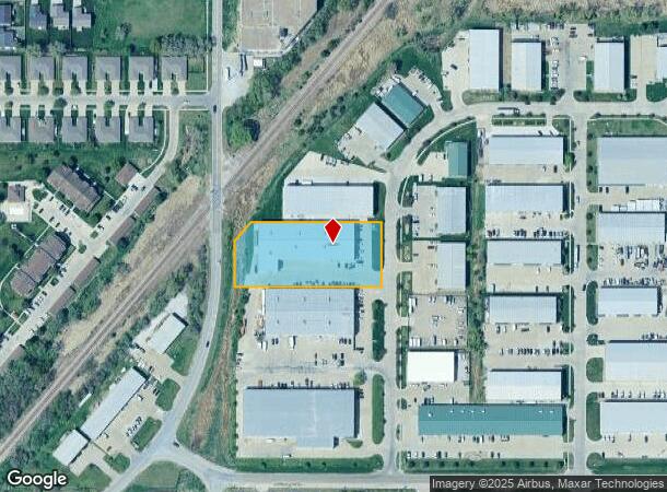
Property Record
1941 Sw 6Th St, Lincoln, NE 68522
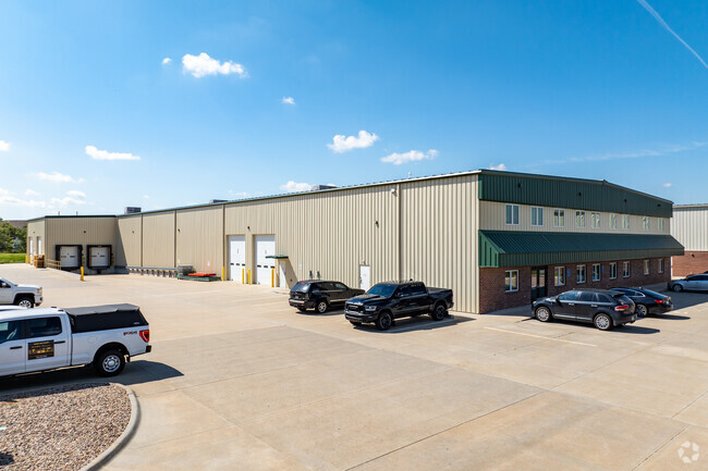
This Property Is For Sale
NEARBY LISTINGS FOR SALE OR LEASE
Property Detail
1941 Sw 6Th St
Lincoln, NE
South Street Business Park Addition
10-34-213-014-000
SOUTH STREET BUSINESS PARK ADDITION, BLOCK 1, LOT 14
Officebuilding
Lancaster
AE
Nebraska
31109C0315F
14
2024
1.58 AC
2025
West
003402
Lincoln
27,560 SF
DEMOGRAPHICS near 1941 Sw 6Th St
1 Mile
3 Mile
5 Mile
2024 Total Population
7,866
68,520
173,819
2029 Population
8,117
70,926
179,506
Pop Growth 2024-2029
+ 3.19%
+ 3.51%
+ 3.27%
Average Age
35
36
37
2024 Total Households
2,848
28,315
71,199
HH Growth 2024-2029
+ 3.30%
+ 4.06%
+ 3.54%
Median Household Inc
$59,741
$48,366
$56,555
Avg Household Size
2.60
2.20
2.30
2024 Avg HH Vehicles
2.00
2.00
2.00
Median Home Value
$167,428
$192,988
$202,145
Median Year Built
1990
1966
1974
Nearby Places
- Restaurants
- Banks
- Shops
- Fitness
- Groceries
PUBLIC TRANSPORTATION
COMMUTER RAIL
Lincoln Amtrak Station (California Zephyr - Amtrak)
DRIVE
WALK
Distance
Lincoln Amtrak Station (California Zephyr - Amtrak)
8 min
3.3 mi
AIRPORT
Lincoln
DRIVE
WALK
Distance
Lincoln
12 min
6.8 mi
Freight Ports
Tulsa Port Of Catoosa
DRIVE
WALK
Distance
Tulsa Port Of Catoosa
470 min
396.3 mi
Nearby Properties
Address
Land Use
TOTAL SIZE
Lot Size
Zoning
Address
Land Use
TOTAL SIZE
Lot Size
Zoning
684,598 SF
21.16 AC
B3
Address
Land Use
TOTAL SIZE
Lot Size
Zoning
134,835 SF
1.22 AC
B4
Address
Land Use
TOTAL SIZE
Lot Size
Zoning
131,328 SF
2.07 AC
P
Address
Land Use
TOTAL SIZE
Lot Size
Zoning
301,402 SF
35.38 AC
H3
Address
Land Use
TOTAL SIZE
Lot Size
Zoning
65,430 SF
1.12 AC
B4
Address
Land Use
TOTAL SIZE
Lot Size
Zoning
182,668 SF
2.07 AC
B4
Address
Land Use
TOTAL SIZE
Lot Size
Zoning
72,047 SF
1.03 AC
B4
Address
Land Use
TOTAL SIZE
Lot Size
Zoning
216,894 SF
1.47 AC
B4
Address
Land Use
TOTAL SIZE
Lot Size
Zoning
708,074 SF
66.04 AC
I1
Address
Land Use
TOTAL SIZE
Lot Size
Zoning
217,115 SF
2.03 AC
B4
Address
Land Use
TOTAL SIZE
Lot Size
Zoning
189,854 SF
2.07 AC
P
Address
Land Use
TOTAL SIZE
Lot Size
Zoning
287,193 SF
6.62 AC
B4
Address
Land Use
TOTAL SIZE
Lot Size
Zoning
174,576 SF
2.07 AC
R6
Address
Land Use
TOTAL SIZE
Lot Size
Zoning
92,418 SF
0.79 AC
B4
Address
Land Use
TOTAL SIZE
Lot Size
Zoning
119,257 SF
1.68 AC
B4
Address
Land Use
TOTAL SIZE
Lot Size
Zoning
180,578 SF
1.32 AC
P
Address
Land Use
TOTAL SIZE
Lot Size
Zoning
56,867 SF
22.10 AC
NULL
Address
Land Use
TOTAL SIZE
Lot Size
Zoning
11.90 AC
P
Address
Land Use
TOTAL SIZE
Lot Size
Zoning
119,655 SF
2.28 AC
B4
Address
Land Use
TOTAL SIZE
Lot Size
Zoning
92,505 SF
2.96 AC
B4
Address
Land Use
TOTAL SIZE
Lot Size
Zoning
47,017 SF
0.92 AC
B4
Address
Land Use
TOTAL SIZE
Lot Size
Zoning
23,881 SF
0.80 AC
B4
Address
Land Use
TOTAL SIZE
Lot Size
Zoning
121,860 SF
6.51 AC
P
Address
Land Use
TOTAL SIZE
Lot Size
Zoning
60,761 SF
0.75 AC
B4
Address
Land Use
TOTAL SIZE
Lot Size
Zoning
110,512 SF
0.98 AC
O1
Address
Land Use
TOTAL SIZE
Lot Size
Zoning
33,730 SF
6.88 AC
NULL
Address
Land Use
TOTAL SIZE
Lot Size
Zoning
149,344 SF
1.57 AC
P
Address
Land Use
TOTAL SIZE
Lot Size
Zoning
182,451 SF
2.07 AC
B4
Address
Land Use
TOTAL SIZE
Lot Size
Zoning
96,694 SF
1.28 AC
B4
Address
Land Use
TOTAL SIZE
Lot Size
Zoning
131,049 SF
78.38 AC
P
The World's #1 Commercial Real Estate Marketplace
Connect with us
© 2025 CoStar Group
The information above has been obtained from sources believed reliable. While we do not doubt its accuracy we have not verified it and make no guarantee, warranty or representation about it. It is your responsibility to independently confirm its accuracy and completeness. Any projections, opinions, assumptions, or estimates used are for example only and do not represent the current or future performance of the property. The value of this transaction to you depends on tax and other factors which should be evaluated by your tax, financial, and legal advisors. You and your advisors should conduct a careful, independent investigation of the property to determine to your satisfaction the suitability of the property for your needs.