Property Record
1941 Triplett Blvd, Akron, OH 44312

Save to a Folder
{{folder.Name}}
{{folder.ListingIds.length}} Properties
{{folder.ListingIds.length}} Property
Create a New Folder
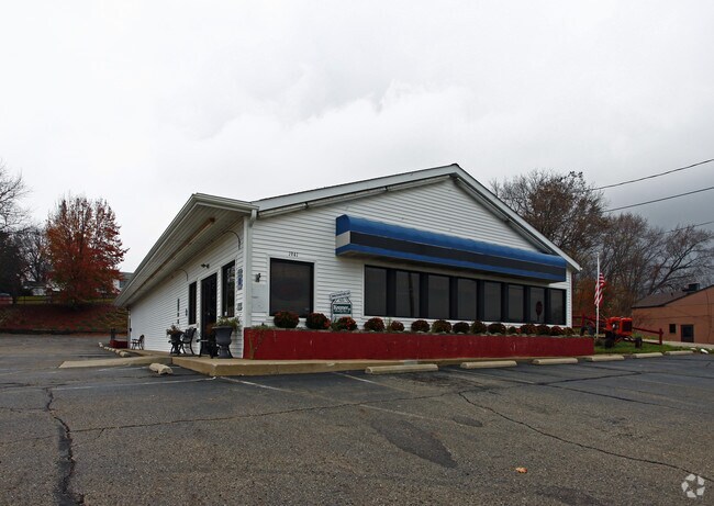
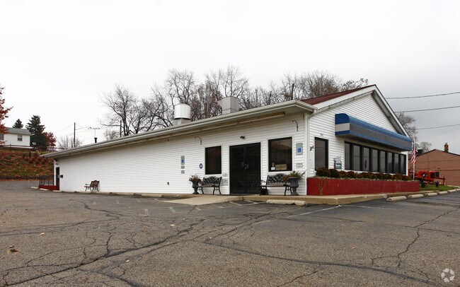
Property Detail
1941 Triplett Blvd
Akron, OH
E MKT AC LOTS 680 THRU 685 INCL ALL
67-58066
Summit
Restaurantbuilding
Ohio
B and X Area of moderate flood hazard, usually the area between the limits of the 100-year and 500-year floods.
681
2025
0.76 AC
2026
Akron
503600
Cleveland
4,593 SF
NEARBY LISTINGS FOR SALE OR LEASE
DEMOGRAPHICS near 1941 Triplett Blvd
1 mile
3 mile
5 mile
2025 Total Population
7,190
74,333
158,691
2030 Population
7,178
74,605
159,319
Pop Growth 2025-2030
(0.17%)
+ 0.37%
+ 0.40%
Average Age
42
40
40
2025 Total Households
3,179
32,047
66,799
HH Growth 2025-2030
(0.22%)
+ 0.31%
+ 0.37%
Median Household Inc
$60,488
$52,501
$52,036
Avg Household Size
2.20
2.30
2.20
2025 Avg HH Vehicles
2.00
2.00
2.00
Median Home Value
$147,713
$128,748
$147,848
Median Year Built
1961
1955
1958
Nearby Places
Map Layers
Map Styles
 Street
 Aerial
Layers
 Traffic
 Biking
Places
Listings with unknown addresses are not visible on the map
- Restaurants
- Banks
- Shops
- Fitness
- Groceries
PUBLIC TRANSPORTATION
COMMUTER RAIL
Drive
Walk
Distance
12 min
6.1 mi
Drive
Walk
Distance
21 min
9.4 mi
AIRPORT
Akron-Canton Regional
Drive
Walk
Distance
Akron-Canton Regional
19 min
10.5 mi
Cleveland-Hopkins International
Drive
Walk
Distance
Cleveland-Hopkins International
64 min
45.2 mi
Nearby Properties
Address
Land Use
TOTAL SIZE
Lot Size
Zoning
Address
Land Use
TOTAL SIZE
Lot Size
Zoning
184.01 AC
Address
Land Use
TOTAL SIZE
Lot Size
Zoning
203,458 SF
10.41 AC
Address
Land Use
TOTAL SIZE
Lot Size
Zoning
162,774 SF
16.58 AC
Address
Land Use
TOTAL SIZE
Lot Size
Zoning
264,753 SF
22.87 AC
Address
Land Use
TOTAL SIZE
Lot Size
Zoning
56.06 AC
Address
Land Use
TOTAL SIZE
Lot Size
Zoning
Address
Land Use
TOTAL SIZE
Lot Size
Zoning
57,369 SF
93.97 AC
Address
Land Use
TOTAL SIZE
Lot Size
Zoning
245,911 SF
14.48 AC
Address
Land Use
TOTAL SIZE
Lot Size
Zoning
142,848 SF
13.85 AC
Address
Land Use
TOTAL SIZE
Lot Size
Zoning
196,767 SF
37.16 AC
Address
Land Use
TOTAL SIZE
Lot Size
Zoning
99,003 SF
20.10 AC
Address
Land Use
TOTAL SIZE
Lot Size
Zoning
639,478 SF
29.51 AC
Address
Land Use
TOTAL SIZE
Lot Size
Zoning
33.14 AC
Address
Land Use
TOTAL SIZE
Lot Size
Zoning
270,860 SF
131.89 AC
Address
Land Use
TOTAL SIZE
Lot Size
Zoning
709,827 SF
8.82 AC
Address
Land Use
TOTAL SIZE
Lot Size
Zoning
56,529 SF
3.67 AC
Address
Land Use
TOTAL SIZE
Lot Size
Zoning
95,696 SF
8.29 AC
Address
Land Use
TOTAL SIZE
Lot Size
Zoning
203,059 SF
55.62 AC
Address
Land Use
TOTAL SIZE
Lot Size
Zoning
72,162 SF
4.76 AC
Address
Land Use
TOTAL SIZE
Lot Size
Zoning
6.06 AC
Address
Land Use
TOTAL SIZE
Lot Size
Zoning
489,909 SF
23.77 AC
Address
Land Use
TOTAL SIZE
Lot Size
Zoning
258,686 SF
19.52 AC
Address
Land Use
TOTAL SIZE
Lot Size
Zoning
5,863 SF
343.43 AC
Address
Land Use
TOTAL SIZE
Lot Size
Zoning
882,093 SF
50.96 AC
Address
Land Use
TOTAL SIZE
Lot Size
Zoning
68,979 SF
5.07 AC
Address
Land Use
TOTAL SIZE
Lot Size
Zoning
65,350 SF
9.99 AC
Address
Land Use
TOTAL SIZE
Lot Size
Zoning
124,939 SF
13.89 AC
Address
Land Use
TOTAL SIZE
Lot Size
Zoning
63,104 SF
13.79 AC
Address
Land Use
TOTAL SIZE
Lot Size
Zoning
667,050 SF
24.55 AC
Address
Land Use
TOTAL SIZE
Lot Size
Zoning
187,454 SF
12.59 AC
The World's #1 Commercial Real Estate Marketplace
Connect with us
© 2026 CoStar Group
The information above has been obtained from sources believed reliable. While we do not doubt its accuracy we have not verified it and make no guarantee, warranty or representation about it. It is your responsibility to independently confirm its accuracy and completeness. Any projections, opinions, assumptions, or estimates used are for example only and do not represent the current or future performance of the property. The value of this transaction to you depends on tax and other factors which should be evaluated by your tax, financial, and legal advisors. You and your advisors should conduct a careful, independent investigation of the property to determine to your satisfaction the suitability of the property for your needs.