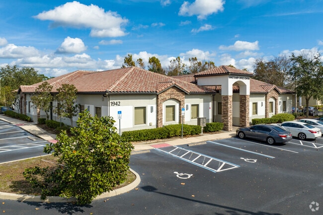
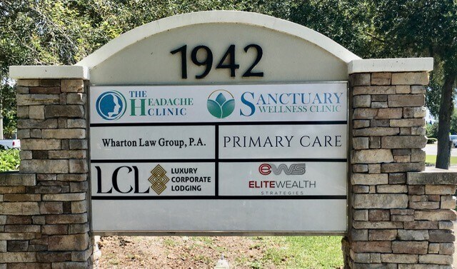
Property Record
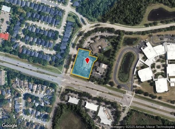
1942 W County Road 419, Chuluota, FL 32766
Current Lease Availabilities
NEARBY LISTINGS FOR SALE OR LEASE
Property Detail
1942 W County Road 419
19-21-32-300-007D-0000
SEC 19 TWP 21S RGE 32E BEG INT NLY R/W CR 419 & SELY R/W SANCTUARY DR RUN N 16DEG 54 MIN 05 SEC E 316.56 FT NELY ON CURVE 10 FT S 73 DEG 05 MIN 55 SEC E 140.88 FT S 16 DEG 54 MIN 05 SEC W 49.05 FT S 73 DEG 05 MIN 55 SEC E 102.10 FT S 16 DEG 54 MIN 05
Officebuilding
Seminole
X
Florida
12117C0195F
1.56 AC
2025
E Seminole Outlying
2025
Orlando
021206
Orlando-Kissimmee-Sanford, FL
10,191 SF
DEMOGRAPHICS near 1942 W County Road 419
1 Mile
3 Mile
5 Mile
2024 Total Population
5,691
39,872
93,970
2029 Population
5,848
41,220
96,793
Pop Growth 2024-2029
+ 2.76%
+ 3.38%
+ 3.00%
Average Age
38
38
36
2024 Total Households
1,737
13,227
28,695
HH Growth 2024-2029
+ 2.82%
+ 3.48%
+ 3.21%
Median Household Inc
$128,270
$104,178
$92,934
Avg Household Size
3.20
3.00
2.80
2024 Avg HH Vehicles
2.00
2.00
2.00
Median Home Value
$443,317
$377,668
$383,426
Median Year Built
2001
1996
1996
Nearby Places
Map Layers
Map Styles
 Street
 Aerial
- Restaurants
- Banks
- Shops
- Fitness
- Groceries
PUBLIC TRANSPORTATION
AIRPORT
Orlando Sanford International
DRIVE
WALK
Distance
Orlando Sanford International
25 min
14.3 mi
Orlando International
DRIVE
WALK
Distance
Orlando International
39 min
27.4 mi
Freight Ports
Port Canaveral
DRIVE
WALK
Distance
Port Canaveral
61 min
43.8 mi
Nearby Properties
Address
Land Use
TOTAL SIZE
Lot Size
Zoning
Address
Land Use
TOTAL SIZE
Lot Size
Zoning
280,279 SF
31.65 AC
A1
Address
Land Use
TOTAL SIZE
Lot Size
Zoning
276,300 SF
3.34 AC
A1
Address
Land Use
TOTAL SIZE
Lot Size
Zoning
5,938 SF
9.14 AC
Address
Land Use
TOTAL SIZE
Lot Size
Zoning
98,868 SF
3.02 AC
Address
Land Use
TOTAL SIZE
Lot Size
Zoning
4,380 SF
20.01 AC
A1
Address
Land Use
TOTAL SIZE
Lot Size
Zoning
906 SF
15.85 AC
C1
Address
Land Use
TOTAL SIZE
Lot Size
Zoning
396,335 SF
5 AC
PLI
Address
Land Use
TOTAL SIZE
Lot Size
Zoning
10,500 SF
21.76 AC
PUD
Address
Land Use
TOTAL SIZE
Lot Size
Zoning
199,560 SF
24.95 AC
PUD
Address
Land Use
TOTAL SIZE
Lot Size
Zoning
130,481 SF
181.40 AC
PUD
Address
Land Use
TOTAL SIZE
Lot Size
Zoning
280,330 SF
14.77 AC
MUDNDD
Address
Land Use
TOTAL SIZE
Lot Size
Zoning
5,992 SF
196.50 AC
A1
Address
Land Use
TOTAL SIZE
Lot Size
Zoning
145,194 SF
34.17 AC
PUD
Address
Land Use
TOTAL SIZE
Lot Size
Zoning
85,813 SF
11.62 AC
PUD
Address
Land Use
TOTAL SIZE
Lot Size
Zoning
4,800 SF
8.27 AC
MUDCHR
Address
Land Use
TOTAL SIZE
Lot Size
Zoning
114,129 SF
12 AC
A1
Address
Land Use
TOTAL SIZE
Lot Size
Zoning
123,578 SF
15.35 AC
PUD
Address
Land Use
TOTAL SIZE
Lot Size
Zoning
17,170 SF
50.47 AC
PUD
Address
Land Use
TOTAL SIZE
Lot Size
Zoning
177,906 SF
4.24 AC
PLI
Address
Land Use
TOTAL SIZE
Lot Size
Zoning
107,275 SF
15.17 AC
PUD
Address
Land Use
TOTAL SIZE
Lot Size
Zoning
93,984 SF
1.60 AC
C1
Address
Land Use
TOTAL SIZE
Lot Size
Zoning
50,203 SF
5.25 AC
PUD
Address
Land Use
TOTAL SIZE
Lot Size
Zoning
69,450 SF
9.30 AC
M1
Address
Land Use
TOTAL SIZE
Lot Size
Zoning
477.31 AC
A1
Address
Land Use
TOTAL SIZE
Lot Size
Zoning
93,832 SF
13.99 AC
PUD
Address
Land Use
TOTAL SIZE
Lot Size
Zoning
31,711 SF
3 AC
A1
Address
Land Use
TOTAL SIZE
Lot Size
Zoning
78,906 SF
5.41 AC
PUD
Address
Land Use
TOTAL SIZE
Lot Size
Zoning
51,872 SF
6.27 AC
PUD
Address
Land Use
TOTAL SIZE
Lot Size
Zoning
11,980 SF
12.26 AC
PLI
Address
Land Use
TOTAL SIZE
Lot Size
Zoning
60 SF
6.57 AC
The World's #1 Commercial Real Estate Marketplace
Connect with us
© 2026 CoStar Group
The information above has been obtained from sources believed reliable. While we do not doubt its accuracy we have not verified it and make no guarantee, warranty or representation about it. It is your responsibility to independently confirm its accuracy and completeness. Any projections, opinions, assumptions, or estimates used are for example only and do not represent the current or future performance of the property. The value of this transaction to you depends on tax and other factors which should be evaluated by your tax, financial, and legal advisors. You and your advisors should conduct a careful, independent investigation of the property to determine to your satisfaction the suitability of the property for your needs.