Property Record
19428 Old Highway 99 Sw, Rochester, WA 98579


NEARBY LISTINGS FOR SALE OR LEASE
Property Detail
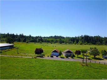
19428 Old Highway 99 Sw
09040003000
Axtell Dlc
Agriculturalland
AXTELL DC COM SE COR SW NE 12-15-3W N3-16-0 W1038.8FN N2-50
X
Thurston
53067C0475F
Washington
2024
42 AC
2024
Outlying Thurston County
012710
Olympia
1,252 SF
Olympia-Tumwater, WA
DEMOGRAPHICS near 19428 Old Highway 99 Sw
1 Mile
3 Mile
5 Mile
2024 Total Population
1,479
7,752
21,989
2029 Population
1,569
8,178
23,576
Pop Growth 2024-2029
+ 6.09%
+ 5.50%
+ 7.22%
Average Age
39
40
41
2024 Total Households
505
2,730
8,057
HH Growth 2024-2029
+ 6.14%
+ 5.46%
+ 7.40%
Median Household Inc
$77,833
$83,277
$75,848
Avg Household Size
2.90
2.80
2.60
2024 Avg HH Vehicles
3.00
3.00
2.00
Median Home Value
$324,609
$370,366
$371,824
Median Year Built
1998
1994
1992
Nearby Places
Map Layers
Map Styles
 Street
 Aerial
- Restaurants
- Banks
- Shops
- Fitness
- Groceries
PUBLIC TRANSPORTATION
COMMUTER RAIL
Centralia Amtrak Station (Amtrak Cascades - Amtrak, Coast Starlight - Amtrak)
DRIVE
WALK
Distance
Centralia Amtrak Station (Amtrak Cascades - Amtrak, Coast Starlight - Amtrak)
12 min
7.7 mi
Freight Ports
Port of Tacoma
DRIVE
WALK
Distance
Port of Tacoma
59 min
48.3 mi
SALE & LEASE HISTORY
LISTING DATE
SALE/LEASE

Jun 20, 2018
For Sale
Nearby Properties
Address
Land Use
TOTAL SIZE
Lot Size
Zoning
Address
Land Use
TOTAL SIZE
Lot Size
Zoning
441,608 SF
Address
Land Use
TOTAL SIZE
Lot Size
Zoning
229,011 SF
209.52 AC
PID
Address
Land Use
TOTAL SIZE
Lot Size
Zoning
155,458 SF
15.79 AC
PMP
Address
Land Use
TOTAL SIZE
Lot Size
Zoning
738,962 SF
16.50 AC
Address
Land Use
TOTAL SIZE
Lot Size
Zoning
297,970 SF
19.32 AC
PID
Address
Land Use
TOTAL SIZE
Lot Size
Zoning
158,948 SF
77.13 AC
RRR1/5
Address
Land Use
TOTAL SIZE
Lot Size
Zoning
23,908 SF
3.74 AC
AC
Address
Land Use
TOTAL SIZE
Lot Size
Zoning
22.44 AC
PMP
Address
Land Use
TOTAL SIZE
Lot Size
Zoning
768 SF
34.16 AC
PID
Address
Land Use
TOTAL SIZE
Lot Size
Zoning
12,616 SF
7.56 AC
AC
Address
Land Use
TOTAL SIZE
Lot Size
Zoning
28,248 SF
4.92 AC
PID
Address
Land Use
TOTAL SIZE
Lot Size
Zoning
4,997 SF
1.13 AC
AC
Address
Land Use
TOTAL SIZE
Lot Size
Zoning
3,848 SF
12.90 AC
R3-6/1
Address
Land Use
TOTAL SIZE
Lot Size
Zoning
10,672 SF
22.93 AC
RCC
Address
Land Use
TOTAL SIZE
Lot Size
Zoning
2,604 SF
6.85 AC
RRR1/5
Address
Land Use
TOTAL SIZE
Lot Size
Zoning
36,440 SF
1.92 AC
AC
Address
Land Use
TOTAL SIZE
Lot Size
Zoning
34,916 SF
62.68 AC
RRR1/5
Address
Land Use
TOTAL SIZE
Lot Size
Zoning
23,941 SF
4.37 AC
PID
Address
Land Use
TOTAL SIZE
Lot Size
Zoning
4,320 SF
1.08 AC
AC
Address
Land Use
TOTAL SIZE
Lot Size
Zoning
34,408 SF
7.21 AC
LI
Address
Land Use
TOTAL SIZE
Lot Size
Zoning
8,423 SF
0.72 AC
AC
Address
Land Use
TOTAL SIZE
Lot Size
Zoning
9.86 AC
PID
Address
Land Use
TOTAL SIZE
Lot Size
Zoning
421.91 AC
PP
Address
Land Use
TOTAL SIZE
Lot Size
Zoning
5.70 AC
AC
Address
Land Use
TOTAL SIZE
Lot Size
Zoning
17,524 SF
4 AC
PID
Address
Land Use
TOTAL SIZE
Lot Size
Zoning
65,780 SF
119.13 AC
RRR1/5
Address
Land Use
TOTAL SIZE
Lot Size
Zoning
23,405 SF
10.22 AC
RCC
Address
Land Use
TOTAL SIZE
Lot Size
Zoning
9.34 AC
PID
Address
Land Use
TOTAL SIZE
Lot Size
Zoning
8,789 SF
0.88 AC
AC
Address
Land Use
TOTAL SIZE
Lot Size
Zoning
3,262 SF
1.06 AC
AC
The World's #1 Commercial Real Estate Marketplace
Connect with us
© 2025 CoStar Group
The information above has been obtained from sources believed reliable. While we do not doubt its accuracy we have not verified it and make no guarantee, warranty or representation about it. It is your responsibility to independently confirm its accuracy and completeness. Any projections, opinions, assumptions, or estimates used are for example only and do not represent the current or future performance of the property. The value of this transaction to you depends on tax and other factors which should be evaluated by your tax, financial, and legal advisors. You and your advisors should conduct a careful, independent investigation of the property to determine to your satisfaction the suitability of the property for your needs.