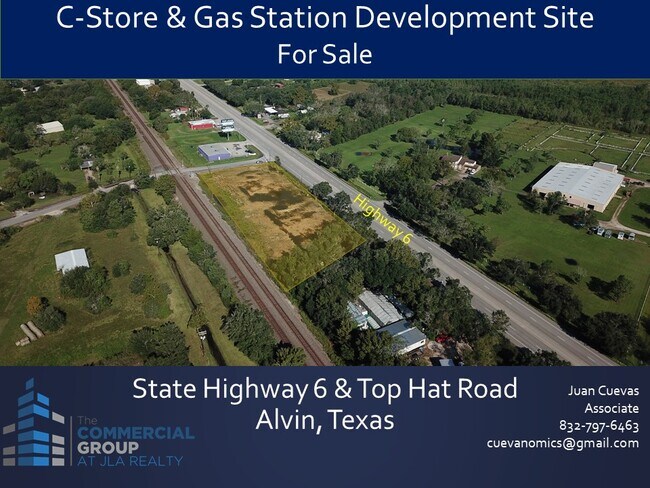
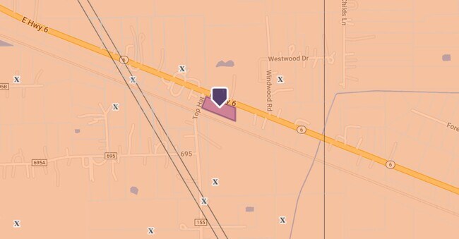
Property Record
19435 E Highway 6, Alvin, TX 77511

Property Detail
19435 E Highway 6
Houston-Pasadena-The Woodlands, TX
ABST 619 I & G N RR SUR SEC 27 PT OF LOT 4 (4-5) GRAHAM TOLAR DAVIS & UZZELL SUB
3673-0000-0004-005
GALVESTON
Commercialnec
Texas
B and X Area of moderate flood hazard, usually the area between the limits of the 100-year and 500-year floods.
4
2024
0.86 AC
2025
Southeast Outlier
723503
Houston
1,800 SF
NEARBY LISTINGS FOR SALE OR LEASE
DEMOGRAPHICS near 19435 E Highway 6
1 mile
3 mile
5 mile
2025 Total Population
1,000
13,874
45,604
2030 Population
1,072
15,141
49,467
Pop Growth 2025-2030
+ 7.20%
+ 9.13%
+ 8.47%
Average Age
43
40
39
2025 Total Households
369
5,400
16,603
HH Growth 2025-2030
+ 7.32%
+ 9.43%
+ 8.79%
Median Household Inc
$119,078
$73,440
$76,532
Avg Household Size
2.60
2.50
2.70
2025 Avg HH Vehicles
2.00
2.00
2.00
Median Home Value
$271,153
$260,158
$268,845
Median Year Built
1992
1988
1990
Nearby Places
Map Layers
Map Styles
 Street
 Aerial
Layers
 Traffic
 Biking
Places
Listings with unknown addresses are not visible on the map
- Restaurants
- Banks
- Shops
- Fitness
- Groceries
PUBLIC TRANSPORTATION
AIRPORT
William P Hobby
Drive
Walk
Distance
William P Hobby
34 min
19.1 mi
Freight Ports
Port of Galveston
Drive
Walk
Distance
Port of Galveston
37 min
24.8 mi
SALE & LEASE HISTORY
LISTING DATE
SALE/LEASE

Oct 12, 2021
For Sale
Aug 04, 2022
For Sale
Nearby Properties
Address
Land Use
TOTAL SIZE
Lot Size
Zoning
Address
Land Use
TOTAL SIZE
Lot Size
Zoning
13.56 AC
Address
Land Use
TOTAL SIZE
Lot Size
Zoning
Address
Land Use
TOTAL SIZE
Lot Size
Zoning
209,431 SF
17.44 AC
Address
Land Use
TOTAL SIZE
Lot Size
Zoning
171,971 SF
10 AC
0062
Address
Land Use
TOTAL SIZE
Lot Size
Zoning
116,628 SF
5.90 AC
0011
Address
Land Use
TOTAL SIZE
Lot Size
Zoning
121,249 SF
5.52 AC
0093
Address
Land Use
TOTAL SIZE
Lot Size
Zoning
46,543 SF
30.89 AC
Address
Land Use
TOTAL SIZE
Lot Size
Zoning
110,165 SF
12.32 AC
Address
Land Use
TOTAL SIZE
Lot Size
Zoning
100,754 SF
5.93 AC
Address
Land Use
TOTAL SIZE
Lot Size
Zoning
83,344 SF
4.40 AC
0002
Address
Land Use
TOTAL SIZE
Lot Size
Zoning
146,535 SF
7.32 AC
Address
Land Use
TOTAL SIZE
Lot Size
Zoning
84,423 SF
7.87 AC
Address
Land Use
TOTAL SIZE
Lot Size
Zoning
80,672 SF
4.58 AC
Address
Land Use
TOTAL SIZE
Lot Size
Zoning
276,750 SF
35.24 AC
Address
Land Use
TOTAL SIZE
Lot Size
Zoning
83,252 SF
6.16 AC
Address
Land Use
TOTAL SIZE
Lot Size
Zoning
77,933 SF
3.67 AC
0113
Address
Land Use
TOTAL SIZE
Lot Size
Zoning
32,340 SF
4.38 AC
0001
Address
Land Use
TOTAL SIZE
Lot Size
Zoning
74,406 SF
11.99 AC
Address
Land Use
TOTAL SIZE
Lot Size
Zoning
70,086 SF
3.16 AC
0115
Address
Land Use
TOTAL SIZE
Lot Size
Zoning
10,160 SF
1.57 AC
Address
Land Use
TOTAL SIZE
Lot Size
Zoning
22,400 SF
2.25 AC
0067
Address
Land Use
TOTAL SIZE
Lot Size
Zoning
16,620 SF
1.59 AC
Address
Land Use
TOTAL SIZE
Lot Size
Zoning
40,484 SF
1.96 AC
Address
Land Use
TOTAL SIZE
Lot Size
Zoning
25,352 SF
2.29 AC
Address
Land Use
TOTAL SIZE
Lot Size
Zoning
65,401 SF
3.25 AC
Address
Land Use
TOTAL SIZE
Lot Size
Zoning
68,796 SF
5.23 AC
Address
Land Use
TOTAL SIZE
Lot Size
Zoning
54,952 SF
6.30 AC
Address
Land Use
TOTAL SIZE
Lot Size
Zoning
1,600 SF
8.82 AC
0081
Address
Land Use
TOTAL SIZE
Lot Size
Zoning
34,152 SF
1.39 AC
Address
Land Use
TOTAL SIZE
Lot Size
Zoning
49,392 SF
5.44 AC
The World's #1 Commercial Real Estate Marketplace
Connect with us
© 2026 CoStar Group
The information above has been obtained from sources believed reliable. While we do not doubt its accuracy we have not verified it and make no guarantee, warranty or representation about it. It is your responsibility to independently confirm its accuracy and completeness. Any projections, opinions, assumptions, or estimates used are for example only and do not represent the current or future performance of the property. The value of this transaction to you depends on tax and other factors which should be evaluated by your tax, financial, and legal advisors. You and your advisors should conduct a careful, independent investigation of the property to determine to your satisfaction the suitability of the property for your needs.