Property Record
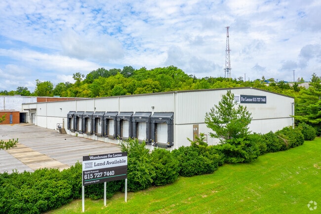
1973 Southerland Dr, Nashville, TN 37207


Current Lease Availabilities
NEARBY LISTINGS FOR SALE OR LEASE
Property Detail
1973 Southerland Dr
060-14-0-026.01
Rucker
Publicstorage
N RUCKER ST E OF BRICK CHURCH PIKE
X
Davidson
47037C0234H
Tennessee
2025
9.40 AC
2025
North
012701
Nashville
100,500 SF
Nashville-Davidson--Murfreesboro--Franklin, TN
DEMOGRAPHICS near 1973 Southerland Dr
1 Mile
3 Mile
5 Mile
2024 Total Population
7,331
80,406
192,995
2029 Population
7,541
81,866
197,024
Pop Growth 2024-2029
+ 2.86%
+ 1.82%
+ 2.09%
Average Age
34
36
37
2024 Total Households
2,715
35,222
86,976
HH Growth 2024-2029
+ 2.73%
+ 1.98%
+ 2.42%
Median Household Inc
$43,580
$59,726
$59,838
Avg Household Size
2.60
2.20
2.10
2024 Avg HH Vehicles
2.00
2.00
2.00
Median Home Value
$354,191
$349,184
$358,562
Median Year Built
1993
1994
1997
Nearby Places
Map Layers
Map Styles
 Street
 Aerial
- Restaurants
- Banks
- Shops
- Fitness
- Groceries
PUBLIC TRANSPORTATION
COMMUTER RAIL
Riverfront (East Corridor Line - Tennessee Regional Transportation Authority Music City Star (Music City Star))
DRIVE
WALK
Distance
Riverfront (East Corridor Line - Tennessee Regional Transportation Authority Music City Star (Music City Star))
8 min
4.6 mi
AIRPORT
Nashville International
DRIVE
WALK
Distance
Nashville International
18 min
12.3 mi
Freight Ports
Port of Mobile
DRIVE
WALK
Distance
Port of Mobile
490 min
449.8 mi
Nearby Properties
Address
Land Use
TOTAL SIZE
Lot Size
Zoning
Address
Land Use
TOTAL SIZE
Lot Size
Zoning
35,620 SF
8.86 AC
IG
Address
Land Use
TOTAL SIZE
Lot Size
Zoning
242,672 SF
16.30 AC
MULTI-ZONE
Address
Land Use
TOTAL SIZE
Lot Size
Zoning
267,538 SF
1.78 AC
MULTI-ZONE
Address
Land Use
TOTAL SIZE
Lot Size
Zoning
226,184 SF
10.01 AC
IWD
Address
Land Use
TOTAL SIZE
Lot Size
Zoning
43,022 SF
17.02 AC
MULTIZONE
Address
Land Use
TOTAL SIZE
Lot Size
Zoning
25,326 SF
16.89 AC
SP
Address
Land Use
TOTAL SIZE
Lot Size
Zoning
34,160 SF
9.20 AC
R10
Address
Land Use
TOTAL SIZE
Lot Size
Zoning
363,125 SF
51.28 AC
MULTI-ZONE
Address
Land Use
TOTAL SIZE
Lot Size
Zoning
37,730 SF
10.71 AC
RS10
Address
Land Use
TOTAL SIZE
Lot Size
Zoning
440,676 SF
7.33 AC
SP
Address
Land Use
TOTAL SIZE
Lot Size
Zoning
55,073 SF
11.42 AC
IWD
Address
Land Use
TOTAL SIZE
Lot Size
Zoning
178,790 SF
4.74 AC
SP
Address
Land Use
TOTAL SIZE
Lot Size
Zoning
25,872 SF
13.31 AC
MUL
Address
Land Use
TOTAL SIZE
Lot Size
Zoning
542,333 SF
4.53 AC
MULTIZONE
Address
Land Use
TOTAL SIZE
Lot Size
Zoning
364,194 SF
2.81 AC
MUIA
Address
Land Use
TOTAL SIZE
Lot Size
Zoning
74,132 SF
6.12 AC
SP
Address
Land Use
TOTAL SIZE
Lot Size
Zoning
29,064 SF
15.11 AC
MULTIZONE
Address
Land Use
TOTAL SIZE
Lot Size
Zoning
56,175 SF
11.40 AC
MULTIZONE
Address
Land Use
TOTAL SIZE
Lot Size
Zoning
357,873 SF
2.49 AC
DTC
Address
Land Use
TOTAL SIZE
Lot Size
Zoning
18,700 SF
8.32 AC
MULTI-ZONE
Address
Land Use
TOTAL SIZE
Lot Size
Zoning
338,436 SF
3.91 AC
MULTI-ZONE
Address
Land Use
TOTAL SIZE
Lot Size
Zoning
31,277 SF
4.49 AC
MULTIZONE
Address
Land Use
TOTAL SIZE
Lot Size
Zoning
342,416 SF
3.16 AC
MULTIZONE
Address
Land Use
TOTAL SIZE
Lot Size
Zoning
310,696 SF
2.15 AC
MUIA
Address
Land Use
TOTAL SIZE
Lot Size
Zoning
295,670 SF
2.17 AC
MULTI-ZONE
Address
Land Use
TOTAL SIZE
Lot Size
Zoning
432,195 SF
6.47 AC
MUG
Address
Land Use
TOTAL SIZE
Lot Size
Zoning
83,995 SF
16.13 AC
IR
Address
Land Use
TOTAL SIZE
Lot Size
Zoning
116,932 SF
5.96 AC
IR
Address
Land Use
TOTAL SIZE
Lot Size
Zoning
327,884 SF
2.93 AC
SP
Address
Land Use
TOTAL SIZE
Lot Size
Zoning
66,976 SF
10.87 AC
MUG
The World's #1 Commercial Real Estate Marketplace
Connect with us
© 2026 CoStar Group
The information above has been obtained from sources believed reliable. While we do not doubt its accuracy we have not verified it and make no guarantee, warranty or representation about it. It is your responsibility to independently confirm its accuracy and completeness. Any projections, opinions, assumptions, or estimates used are for example only and do not represent the current or future performance of the property. The value of this transaction to you depends on tax and other factors which should be evaluated by your tax, financial, and legal advisors. You and your advisors should conduct a careful, independent investigation of the property to determine to your satisfaction the suitability of the property for your needs.