Property Record
1944 42Nd St Ne, Cedar Rapids, IA 52402

Save to a Folder
{{folder.Name}}
{{folder.ListingIds.length}} Properties
{{folder.ListingIds.length}} Property
Create a New Folder
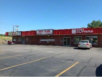
Property Detail
1944 42Nd St Ne
Cedar Rapids, IA
A.P. #441 STR/LB 1
14044-58010-00000
LINN
Storebuilding
Iowa
A Areas with a 1% annual chance of flooding and a 26% chance of flooding over the life of a 30-year mortgage.
1
2024
0.53 AC
2025
Iowa City/Waterloo
000800
Other Market Areas
5,461 SF
NEARBY LISTINGS FOR SALE OR LEASE
DEMOGRAPHICS near 1944 42Nd St Ne
1 mile
3 mile
5 mile
2025 Total Population
7,994
70,666
147,875
2030 Population
8,032
71,550
149,323
Pop Growth 2025-2030
+ 0.48%
+ 1.25%
+ 0.98%
Average Age
40
40
40
2025 Total Households
3,584
30,525
62,184
HH Growth 2025-2030
+ 0.47%
+ 1.28%
+ 1.01%
Median Household Inc
$70,722
$69,517
$70,841
Avg Household Size
2.20
2.20
2.30
2025 Avg HH Vehicles
2.00
2.00
2.00
Median Home Value
$181,209
$208,190
$206,052
Median Year Built
1967
1974
1972
Nearby Places
Map Layers
Map Styles
 Street
 Aerial
Layers
 Traffic
 Biking
Places
Listings with unknown addresses are not visible on the map
- Restaurants
- Banks
- Shops
- Fitness
- Groceries
PUBLIC TRANSPORTATION
AIRPORT
The Eastern Iowa
Drive
Walk
Distance
The Eastern Iowa
20 min
12.8 mi
Freight Ports
Port Milwaukee
Drive
Walk
Distance
Port Milwaukee
290 min
244.7 mi
Nearby Properties
Address
Land Use
TOTAL SIZE
Lot Size
Zoning
Address
Land Use
TOTAL SIZE
Lot Size
Zoning
355,567 SF
14.60 AC
Address
Land Use
TOTAL SIZE
Lot Size
Zoning
171,842 SF
4.16 AC
Address
Land Use
TOTAL SIZE
Lot Size
Zoning
264,086 SF
21.44 AC
Address
Land Use
TOTAL SIZE
Lot Size
Zoning
218,747 SF
9.45 AC
Address
Land Use
TOTAL SIZE
Lot Size
Zoning
530,727 SF
28.94 AC
Address
Land Use
TOTAL SIZE
Lot Size
Zoning
73,012 SF
2.60 AC
Address
Land Use
TOTAL SIZE
Lot Size
Zoning
276,234 SF
44.53 AC
Address
Land Use
TOTAL SIZE
Lot Size
Zoning
70,022 SF
8.27 AC
Address
Land Use
TOTAL SIZE
Lot Size
Zoning
97,940 SF
52.22 AC
Address
Land Use
TOTAL SIZE
Lot Size
Zoning
103,528 SF
18.54 AC
Address
Land Use
TOTAL SIZE
Lot Size
Zoning
60,910 SF
2.48 AC
Address
Land Use
TOTAL SIZE
Lot Size
Zoning
140,672 SF
15.99 AC
Address
Land Use
TOTAL SIZE
Lot Size
Zoning
189,595 SF
19.12 AC
Address
Land Use
TOTAL SIZE
Lot Size
Zoning
1,156,491 SF
137 AC
Address
Land Use
TOTAL SIZE
Lot Size
Zoning
74,015 SF
6.59 AC
Address
Land Use
TOTAL SIZE
Lot Size
Zoning
67,971 SF
Address
Land Use
TOTAL SIZE
Lot Size
Zoning
406,933 SF
61.58 AC
Address
Land Use
TOTAL SIZE
Lot Size
Zoning
110,583 SF
15.56 AC
Address
Land Use
TOTAL SIZE
Lot Size
Zoning
34,710 SF
3.30 AC
Address
Land Use
TOTAL SIZE
Lot Size
Zoning
32,855 SF
1.37 AC
Address
Land Use
TOTAL SIZE
Lot Size
Zoning
69,683 SF
24.78 AC
Address
Land Use
TOTAL SIZE
Lot Size
Zoning
61,291 SF
35.88 AC
Address
Land Use
TOTAL SIZE
Lot Size
Zoning
45,012 SF
0.85 AC
Address
Land Use
TOTAL SIZE
Lot Size
Zoning
44,972 SF
7.03 AC
Address
Land Use
TOTAL SIZE
Lot Size
Zoning
45,098 SF
3.02 AC
Address
Land Use
TOTAL SIZE
Lot Size
Zoning
90,345 SF
40 AC
Address
Land Use
TOTAL SIZE
Lot Size
Zoning
28,506 SF
5.30 AC
Address
Land Use
TOTAL SIZE
Lot Size
Zoning
67,108 SF
4.81 AC
Address
Land Use
TOTAL SIZE
Lot Size
Zoning
47,710 SF
0.71 AC
Address
Land Use
TOTAL SIZE
Lot Size
Zoning
225,076 SF
17.04 AC
The World's #1 Commercial Real Estate Marketplace
Connect with us
© 2026 CoStar Group
The information above has been obtained from sources believed reliable. While we do not doubt its accuracy we have not verified it and make no guarantee, warranty or representation about it. It is your responsibility to independently confirm its accuracy and completeness. Any projections, opinions, assumptions, or estimates used are for example only and do not represent the current or future performance of the property. The value of this transaction to you depends on tax and other factors which should be evaluated by your tax, financial, and legal advisors. You and your advisors should conduct a careful, independent investigation of the property to determine to your satisfaction the suitability of the property for your needs.