Property Record
1944 Wager Rd, Erie, PA 16509


NEARBY LISTINGS FOR SALE OR LEASE
-
-
View all Erie listings for sale on LoopNet.com
Property Detail
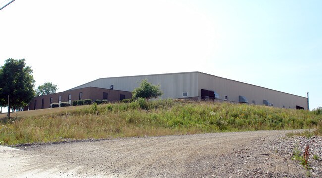
1944 Wager Rd
33-156-641.1-002.00
Thomas E Bundy Industrial Park First Pha
Warehouse
1944 WAGER RD 7.572 AC
X
Erie
42049C0207D
Pennsylvania
2025
7.57 AC
2025
Outlying Erie County
011001
Erie
41,804 SF
Erie, PA
DEMOGRAPHICS near 1944 Wager Rd
1 Mile
3 Mile
5 Mile
2024 Total Population
2,947
45,063
126,203
2029 Population
2,891
44,359
124,761
Pop Growth 2024-2029
(1.90%)
(1.56%)
(1.14%)
Average Age
39
40
40
2024 Total Households
1,309
17,083
50,892
HH Growth 2024-2029
(2.06%)
(1.75%)
(1.24%)
Median Household Inc
$58,870
$56,128
$47,986
Avg Household Size
2.20
2.40
2.30
2024 Avg HH Vehicles
2.00
2.00
1.00
Median Home Value
$177,023
$126,620
$124,096
Median Year Built
1983
1963
1956
Nearby Places
Map Layers
Map Styles
 Street
 Aerial
- Restaurants
- Banks
- Shops
- Fitness
- Groceries
PUBLIC TRANSPORTATION
COMMUTER RAIL
DRIVE
WALK
Distance
13 min
5.2 mi
AIRPORT
Erie International/Tom Ridge Field
DRIVE
WALK
Distance
Erie International/Tom Ridge Field
24 min
13.5 mi
Nearby Properties
Address
Land Use
TOTAL SIZE
Lot Size
Zoning
Address
Land Use
TOTAL SIZE
Lot Size
Zoning
104,159 SF
255.72 AC
B1
Address
Land Use
TOTAL SIZE
Lot Size
Zoning
31,764 SF
46.83 AC
R3
Address
Land Use
TOTAL SIZE
Lot Size
Zoning
68,626 SF
86.88 AC
B1
Address
Land Use
TOTAL SIZE
Lot Size
Zoning
23,092 SF
31.24 AC
DR
Address
Land Use
TOTAL SIZE
Lot Size
Zoning
178,236 SF
26.15 AC
RLB
Address
Land Use
TOTAL SIZE
Lot Size
Zoning
18.55 AC
M1
Address
Land Use
TOTAL SIZE
Lot Size
Zoning
70,092 SF
10.78 AC
DR
Address
Land Use
TOTAL SIZE
Lot Size
Zoning
59,300 SF
16.25 AC
Address
Land Use
TOTAL SIZE
Lot Size
Zoning
23.95 AC
DR
Address
Land Use
TOTAL SIZE
Lot Size
Zoning
92,284 SF
3.94 AC
B3
Address
Land Use
TOTAL SIZE
Lot Size
Zoning
118,270 SF
5.64 AC
R2A
Address
Land Use
TOTAL SIZE
Lot Size
Zoning
12,200 SF
368.69 AC
I2
Address
Land Use
TOTAL SIZE
Lot Size
Zoning
41,976 SF
6.50 AC
R2A
Address
Land Use
TOTAL SIZE
Lot Size
Zoning
4.94 AC
R3
Address
Land Use
TOTAL SIZE
Lot Size
Zoning
103,896 SF
9.06 AC
DR
Address
Land Use
TOTAL SIZE
Lot Size
Zoning
53,376 SF
2.59 AC
R3
Address
Land Use
TOTAL SIZE
Lot Size
Zoning
2.67 AC
R2
Address
Land Use
TOTAL SIZE
Lot Size
Zoning
103,790 SF
3.45 AC
C3
Address
Land Use
TOTAL SIZE
Lot Size
Zoning
71,380 SF
6.66 AC
B1
Address
Land Use
TOTAL SIZE
Lot Size
Zoning
3.60 AC
R1
Address
Land Use
TOTAL SIZE
Lot Size
Zoning
65,776 SF
5.76 AC
B1
Address
Land Use
TOTAL SIZE
Lot Size
Zoning
10.99 AC
Address
Land Use
TOTAL SIZE
Lot Size
Zoning
66,381 SF
1.90 AC
R1
Address
Land Use
TOTAL SIZE
Lot Size
Zoning
66,112 SF
14.58 AC
R2
Address
Land Use
TOTAL SIZE
Lot Size
Zoning
77,126 SF
8.85 AC
C1
Address
Land Use
TOTAL SIZE
Lot Size
Zoning
19,196 SF
2.50 AC
B2
Address
Land Use
TOTAL SIZE
Lot Size
Zoning
480 SF
21.46 AC
CR
Address
Land Use
TOTAL SIZE
Lot Size
Zoning
14,594 SF
8.63 AC
DR
Address
Land Use
TOTAL SIZE
Lot Size
Zoning
3.67 AC
R1
Address
Land Use
TOTAL SIZE
Lot Size
Zoning
5.80 AC
R1
The World's #1 Commercial Real Estate Marketplace
Connect with us
© 2026 CoStar Group
The information above has been obtained from sources believed reliable. While we do not doubt its accuracy we have not verified it and make no guarantee, warranty or representation about it. It is your responsibility to independently confirm its accuracy and completeness. Any projections, opinions, assumptions, or estimates used are for example only and do not represent the current or future performance of the property. The value of this transaction to you depends on tax and other factors which should be evaluated by your tax, financial, and legal advisors. You and your advisors should conduct a careful, independent investigation of the property to determine to your satisfaction the suitability of the property for your needs.