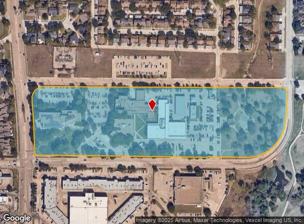
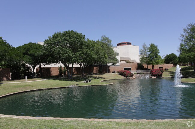
Property Record
1945 E Jackson Rd, Carrollton, TX 75006

NEARBY LISTINGS FOR SALE OR LEASE
Property Detail
1945 E Jackson Rd
Dallas-Fort Worth-Arlington, TX
Carrollton Municipal Complex
14016540010010000
CARROLLTON MUNICIPAL COMPLEX BLK 1 LOT 1 ACS 17.305 VOL89084/2631 CO-DALLAS 0165400100100 1140165400A
Governmentalpublicusegeneral
Dallas
AE
Texas
48113C0160K
1
0
17.31 AC
2025
Quorum/Bent Tree
013720
Dallas/Ft Worth
100 SF
DEMOGRAPHICS near 1945 E Jackson Rd
1 Mile
3 Mile
5 Mile
2024 Total Population
14,322
126,639
335,811
2029 Population
14,196
139,035
368,649
Pop Growth 2024-2029
(0.88%)
+ 9.79%
+ 9.78%
Average Age
40
39
38
2024 Total Households
4,993
49,947
143,752
HH Growth 2024-2029
(1.18%)
+ 10.67%
+ 10.02%
Median Household Inc
$85,125
$72,631
$80,551
Avg Household Size
2.80
2.50
2.30
2024 Avg HH Vehicles
2.00
2.00
2.00
Median Home Value
$276,165
$286,046
$351,377
Median Year Built
1979
1984
1989
Nearby Places
Map Layers
Map Styles
 Street
 Aerial
- Restaurants
- Banks
- Shops
- Fitness
- Groceries
PUBLIC TRANSPORTATION
COMMUTER RAIL
Trinity Mills Station (Green Line - Dallas Area Rapid Transit (DART))
DRIVE
WALK
Distance
Trinity Mills Station (Green Line - Dallas Area Rapid Transit (DART))
6 min
2.6 mi
Hebron Station (A-train - Denton County Transportation Authority)
DRIVE
WALK
Distance
Hebron Station (A-train - Denton County Transportation Authority)
12 min
7.0 mi
AIRPORT
Dallas Love Field
DRIVE
WALK
Distance
Dallas Love Field
26 min
16.0 mi
Dallas-Fort Worth International
DRIVE
WALK
Distance
Dallas-Fort Worth International
22 min
16.0 mi
Freight Ports
Port of Shreveport
DRIVE
WALK
Distance
Port of Shreveport
230 min
209.8 mi
Nearby Properties
Address
Land Use
TOTAL SIZE
Lot Size
Zoning
Address
Land Use
TOTAL SIZE
Lot Size
Zoning
417,990 SF
10.42 AC
Address
Land Use
TOTAL SIZE
Lot Size
Zoning
660,180 SF
29.95 AC
Address
Land Use
TOTAL SIZE
Lot Size
Zoning
513,871 SF
3.63 AC
Z235
Address
Land Use
TOTAL SIZE
Lot Size
Zoning
396,669 SF
18.50 AC
Address
Land Use
TOTAL SIZE
Lot Size
Zoning
321,732 SF
4.05 AC
Z235
Address
Land Use
TOTAL SIZE
Lot Size
Zoning
255,627 SF
14.79 AC
Z123
Address
Land Use
TOTAL SIZE
Lot Size
Zoning
266,871 SF
87 SF
Address
Land Use
TOTAL SIZE
Lot Size
Zoning
725,972 SF
4 AC
Address
Land Use
TOTAL SIZE
Lot Size
Zoning
287,002 SF
9.61 AC
Address
Land Use
TOTAL SIZE
Lot Size
Zoning
189,500 SF
53.90 AC
Address
Land Use
TOTAL SIZE
Lot Size
Zoning
349,784 SF
17.71 AC
Address
Land Use
TOTAL SIZE
Lot Size
Zoning
308,779 SF
19.42 AC
Z235
Address
Land Use
TOTAL SIZE
Lot Size
Zoning
268,132 SF
16.19 AC
Z235
Address
Land Use
TOTAL SIZE
Lot Size
Zoning
397,889 SF
23.14 AC
2A
Address
Land Use
TOTAL SIZE
Lot Size
Zoning
270,915 SF
3.91 AC
Z84
Address
Land Use
TOTAL SIZE
Lot Size
Zoning
380,304 SF
15 AC
1G
Address
Land Use
TOTAL SIZE
Lot Size
Zoning
374,093 SF
21.54 AC
Z268
Address
Land Use
TOTAL SIZE
Lot Size
Zoning
711,360 SF
32.62 AC
Address
Land Use
TOTAL SIZE
Lot Size
Zoning
210,289 SF
10.16 AC
Z147
Address
Land Use
TOTAL SIZE
Lot Size
Zoning
228,674 SF
11.81 AC
Z235
Address
Land Use
TOTAL SIZE
Lot Size
Zoning
294,764 SF
18 AC
Address
Land Use
TOTAL SIZE
Lot Size
Zoning
359,462 SF
13.67 AC
1B
Address
Land Use
TOTAL SIZE
Lot Size
Zoning
293,588 SF
17.04 AC
Address
Land Use
TOTAL SIZE
Lot Size
Zoning
262,065 SF
7.77 AC
1A
Address
Land Use
TOTAL SIZE
Lot Size
Zoning
90,900 SF
10.21 AC
Address
Land Use
TOTAL SIZE
Lot Size
Zoning
268,158 SF
12.25 AC
1G
Address
Land Use
TOTAL SIZE
Lot Size
Zoning
218,648 SF
11.11 AC
1B
Address
Land Use
TOTAL SIZE
Lot Size
Zoning
243,296 SF
9.40 AC
1G
Address
Land Use
TOTAL SIZE
Lot Size
Zoning
213,216 SF
18.94 AC
Z235
Address
Land Use
TOTAL SIZE
Lot Size
Zoning
219,057 SF
12.63 AC
2B
The World's #1 Commercial Real Estate Marketplace
Connect with us
© 2026 CoStar Group
The information above has been obtained from sources believed reliable. While we do not doubt its accuracy we have not verified it and make no guarantee, warranty or representation about it. It is your responsibility to independently confirm its accuracy and completeness. Any projections, opinions, assumptions, or estimates used are for example only and do not represent the current or future performance of the property. The value of this transaction to you depends on tax and other factors which should be evaluated by your tax, financial, and legal advisors. You and your advisors should conduct a careful, independent investigation of the property to determine to your satisfaction the suitability of the property for your needs.