Property Record
19459 W Riverview Dr, Post Falls, ID 83854
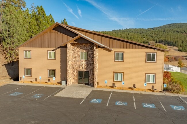


Property Detail
19459 W Riverview Dr
50N05W180800
TAX#24979 EX RW, TAX#5009, NE-NW & NW-NE N OF RD EX TAX#S 1850N05W
Realpropertynec
Kootenai
RUR
Idaho
B and X Area of moderate flood hazard, usually the area between the limits of the 100-year and 500-year floods.
4.47 AC
2025
Kootenai
2025
Coeur D'Alene
000401
Coeur d'Alene, ID
9,300 SF
NEARBY LISTINGS FOR SALE OR LEASE
-
-
View all Post Falls listings for sale on LoopNet.com
DEMOGRAPHICS near 19459 W Riverview Dr
1 mile
3 mile
5 mile
2025 Total Population
570
12,307
52,116
2030 Population
600
12,864
54,277
Pop Growth 2025-2030
+ 5.26%
+ 4.53%
+ 4.15%
Average Age
40
39
40
2025 Total Households
191
4,502
19,641
HH Growth 2025-2030
+ 5.24%
+ 4.73%
+ 4.23%
Median Household Inc
$118,269
$74,035
$80,533
Avg Household Size
2.90
2.70
2.60
2025 Avg HH Vehicles
3.00
2.00
2.00
Median Home Value
$653,571
$495,686
$494,789
Median Year Built
1996
2001
1997
Nearby Places
Map Layers
Map Styles
 Street
 Aerial
Layers
 Traffic
 Biking
Places
Listings with unknown addresses are not visible on the map
- Restaurants
- Banks
- Shops
- Fitness
- Groceries
PUBLIC TRANSPORTATION
AIRPORT
Spokane International
Drive
Walk
Distance
Spokane International
37 min
26.7 mi
Freight Ports
Port of Everett
Drive
Walk
Distance
Port of Everett
365 min
322.3 mi
SALE & LEASE HISTORY
LISTING DATE
SALE/LEASE

Oct 23, 2024
For Sale
Nearby Properties
Address
Land Use
TOTAL SIZE
Lot Size
Zoning
Address
Land Use
TOTAL SIZE
Lot Size
Zoning
53,118 SF
7.61 AC
Address
Land Use
TOTAL SIZE
Lot Size
Zoning
150,900 SF
7.24 AC
AG
Address
Land Use
TOTAL SIZE
Lot Size
Zoning
42,636 SF
24.81 AC
Address
Land Use
TOTAL SIZE
Lot Size
Zoning
235,906 SF
13.17 AC
Address
Land Use
TOTAL SIZE
Lot Size
Zoning
25,698 SF
11.33 AC
Address
Land Use
TOTAL SIZE
Lot Size
Zoning
465,080 SF
31.43 AC
Address
Land Use
TOTAL SIZE
Lot Size
Zoning
145,377 SF
35.35 AC
Address
Land Use
TOTAL SIZE
Lot Size
Zoning
78,795 SF
39.53 AC
C2
Address
Land Use
TOTAL SIZE
Lot Size
Zoning
26,619 SF
15 AC
Address
Land Use
TOTAL SIZE
Lot Size
Zoning
165,984 SF
9.61 AC
Address
Land Use
TOTAL SIZE
Lot Size
Zoning
129,238 SF
24.58 AC
AG
Address
Land Use
TOTAL SIZE
Lot Size
Zoning
156,211 SF
17.09 AC
Address
Land Use
TOTAL SIZE
Lot Size
Zoning
199,920 SF
18.36 AC
COMDEV
Address
Land Use
TOTAL SIZE
Lot Size
Zoning
85,000 SF
1.22 AC
Address
Land Use
TOTAL SIZE
Lot Size
Zoning
64,648 SF
14.82 AC
AG
Address
Land Use
TOTAL SIZE
Lot Size
Zoning
60,246 SF
3.67 AC
Address
Land Use
TOTAL SIZE
Lot Size
Zoning
103,056 SF
8.18 AC
Address
Land Use
TOTAL SIZE
Lot Size
Zoning
115,992 SF
6.87 AC
Address
Land Use
TOTAL SIZE
Lot Size
Zoning
21,008 SF
2.53 AC
Address
Land Use
TOTAL SIZE
Lot Size
Zoning
31,986 SF
15.98 AC
Address
Land Use
TOTAL SIZE
Lot Size
Zoning
70,560 SF
14.69 AC
COMDEV
Address
Land Use
TOTAL SIZE
Lot Size
Zoning
108,441 SF
10.01 AC
COM
Address
Land Use
TOTAL SIZE
Lot Size
Zoning
66,603 SF
37.87 AC
R-5
Address
Land Use
TOTAL SIZE
Lot Size
Zoning
34,688 SF
5.50 AC
Address
Land Use
TOTAL SIZE
Lot Size
Zoning
41,462 SF
10 AC
Address
Land Use
TOTAL SIZE
Lot Size
Zoning
28,005 SF
2.98 AC
Address
Land Use
TOTAL SIZE
Lot Size
Zoning
53,900 SF
4.37 AC
Address
Land Use
TOTAL SIZE
Lot Size
Zoning
28,579 SF
4.51 AC
Address
Land Use
TOTAL SIZE
Lot Size
Zoning
4.02 AC
The World's #1 Commercial Real Estate Marketplace
Connect with us
© 2026 CoStar Group
The information above has been obtained from sources believed reliable. While we do not doubt its accuracy we have not verified it and make no guarantee, warranty or representation about it. It is your responsibility to independently confirm its accuracy and completeness. Any projections, opinions, assumptions, or estimates used are for example only and do not represent the current or future performance of the property. The value of this transaction to you depends on tax and other factors which should be evaluated by your tax, financial, and legal advisors. You and your advisors should conduct a careful, independent investigation of the property to determine to your satisfaction the suitability of the property for your needs.