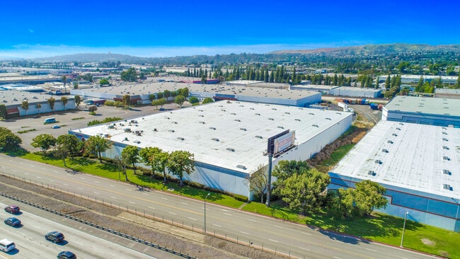
Property Record
19465 E Walnut Dr N, Rowland Heights, CA 91748

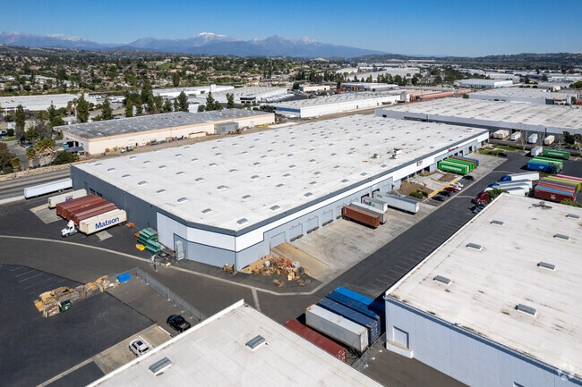
Current Lease Availabilities
Property Detail
19465 E Walnut Dr N
8760-008-005
*TR=PARCEL MAP AS PER BK 125 P 78-80 OF PM*THAT POR OUTSIDE SOUTHEAST MOSQUITO ABATEMENT DIST OF LOT 2
Warehouse
LOS ANGELES
IDM*
California
B and X Area of moderate flood hazard, usually the area between the limits of the 100-year and 500-year floods.
2
2025
13.22 AC
2025
City of Industry
408724
Los Angeles
562,320 SF
Los Angeles-Long Beach-Glendale, CA
NEARBY LISTINGS FOR SALE OR LEASE
DEMOGRAPHICS near 19465 E Walnut Dr N
1 mile
3 mile
5 mile
2025 Total Population
15,291
121,843
272,140
2030 Population
15,114
120,067
269,220
Pop Growth 2025-2030
(1.16%)
(1.46%)
(1.07%)
Average Age
43
42
42
2025 Total Households
4,481
35,809
81,239
HH Growth 2025-2030
(1.43%)
(1.66%)
(1.23%)
Median Household Inc
$90,737
$99,937
$107,184
Avg Household Size
3.30
3.30
3.20
2025 Avg HH Vehicles
2.00
2.00
2.00
Median Home Value
$706,070
$800,899
$814,303
Median Year Built
1973
1975
1974
Nearby Places
Map Layers
Map Styles
 Street
 Aerial
Layers
 Traffic
 Biking
Places
Listings with unknown addresses are not visible on the map
- Restaurants
- Banks
- Shops
- Fitness
- Groceries
PUBLIC TRANSPORTATION
COMMUTER RAIL
Industry (Riverside Line - Southern California Regional Rail Authority (Metrolink))
Drive
Walk
Distance
Industry (Riverside Line - Southern California Regional Rail Authority (Metrolink))
6 min
2.9 mi
Covina (San Bernardino Line - Southern California Regional Rail Authority (Metrolink))
Drive
Walk
Distance
Covina (San Bernardino Line - Southern California Regional Rail Authority (Metrolink))
18 min
9.7 mi
AIRPORT
Ontario International
Drive
Walk
Distance
Ontario International
26 min
19.5 mi
John Wayne/Orange County
Drive
Walk
Distance
John Wayne/Orange County
34 min
26.2 mi
Long Beach (Daugherty Field)
Drive
Walk
Distance
Long Beach (Daugherty Field)
41 min
30.3 mi
Freight Ports
Port of Long Beach
Drive
Walk
Distance
Port of Long Beach
47 min
36.0 mi
Nearby Properties
Address
Land Use
TOTAL SIZE
Lot Size
Zoning
Address
Land Use
TOTAL SIZE
Lot Size
Zoning
421,122 SF
1.30 AC
IDM*
Address
Land Use
TOTAL SIZE
Lot Size
Zoning
286,700 SF
13.31 AC
IDMA*
Address
Land Use
TOTAL SIZE
Lot Size
Zoning
221,018 SF
26.87 AC
IDM*
Address
Land Use
TOTAL SIZE
Lot Size
Zoning
996,725 SF
33.01 AC
1DM*
Address
Land Use
TOTAL SIZE
Lot Size
Zoning
236,508 SF
11.42 AC
LCC2DP*
Address
Land Use
TOTAL SIZE
Lot Size
Zoning
198,188 SF
27.20 AC
IDM*
Address
Land Use
TOTAL SIZE
Lot Size
Zoning
146,466 SF
6.99 AC
IDM*
Address
Land Use
TOTAL SIZE
Lot Size
Zoning
681,411 SF
24.61 AC
IDC*
Address
Land Use
TOTAL SIZE
Lot Size
Zoning
354,888 SF
8.54 AC
IDM*
Address
Land Use
TOTAL SIZE
Lot Size
Zoning
84,890 SF
4.93 AC
IDM11/2*
Address
Land Use
TOTAL SIZE
Lot Size
Zoning
196,965 SF
27.03 AC
IDMA*
Address
Land Use
TOTAL SIZE
Lot Size
Zoning
1,092,435 SF
28.50 AC
Address
Land Use
TOTAL SIZE
Lot Size
Zoning
350,178 SF
14.97 AC
IDM*
Address
Land Use
TOTAL SIZE
Lot Size
Zoning
366,329 SF
16.15 AC
IDM*
Address
Land Use
TOTAL SIZE
Lot Size
Zoning
498,696 SF
22.90 AC
1DM*
Address
Land Use
TOTAL SIZE
Lot Size
Zoning
118,432 SF
10.71 AC
LCR19000*
Address
Land Use
TOTAL SIZE
Lot Size
Zoning
163,346 SF
9.70 AC
IDM*
Address
Land Use
TOTAL SIZE
Lot Size
Zoning
175,880 SF
8.03 AC
IDM*
Address
Land Use
TOTAL SIZE
Lot Size
Zoning
887,697 SF
21.59 AC
IDM*
Address
Land Use
TOTAL SIZE
Lot Size
Zoning
149,110 SF
8.48 AC
WCPCD1*
Address
Land Use
TOTAL SIZE
Lot Size
Zoning
112,536 SF
4.13 AC
IDM*
Address
Land Use
TOTAL SIZE
Lot Size
Zoning
609,112 SF
13.90 AC
IDM*
Address
Land Use
TOTAL SIZE
Lot Size
Zoning
199,164 SF
11.06 AC
1DM*
Address
Land Use
TOTAL SIZE
Lot Size
Zoning
950,576 SF
24.53 AC
IDM*
Address
Land Use
TOTAL SIZE
Lot Size
Zoning
250,080 SF
14.35 AC
IDM*
Address
Land Use
TOTAL SIZE
Lot Size
Zoning
57,288 SF
4.33 AC
LCC2DPBE*
Address
Land Use
TOTAL SIZE
Lot Size
Zoning
371,694 SF
8.60 AC
IDC*
Address
Land Use
TOTAL SIZE
Lot Size
Zoning
80,608 SF
5.34 AC
WCPCD1*
Address
Land Use
TOTAL SIZE
Lot Size
Zoning
80,608 SF
4.80 AC
WCPCD1*
Address
Land Use
TOTAL SIZE
Lot Size
Zoning
81,072 SF
4.95 AC
WCPCD1*
The World's #1 Commercial Real Estate Marketplace
Connect with us
© 2026 CoStar Group
The information above has been obtained from sources believed reliable. While we do not doubt its accuracy we have not verified it and make no guarantee, warranty or representation about it. It is your responsibility to independently confirm its accuracy and completeness. Any projections, opinions, assumptions, or estimates used are for example only and do not represent the current or future performance of the property. The value of this transaction to you depends on tax and other factors which should be evaluated by your tax, financial, and legal advisors. You and your advisors should conduct a careful, independent investigation of the property to determine to your satisfaction the suitability of the property for your needs.