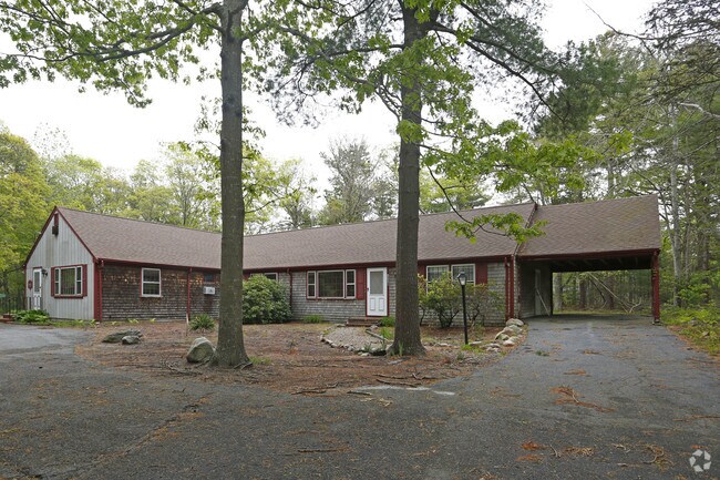
Property Record
1949 Falmouth Rd, Centerville, MA 02632

NEARBY LISTINGS FOR SALE OR LEASE
Property Detail
1949 Falmouth Rd
Barnstable Town, MA
Barnstable
CENT-000189-000000-000003
Massachusetts
Sfr
1.53 AC
X
Cape Cod
25001C0563J
Other Market Areas
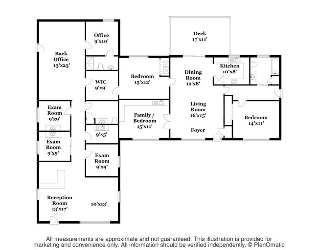
2,568 SF
DEMOGRAPHICS near 1949 Falmouth Rd
1 Mile
3 Mile
5 Mile
2024 Total Population
4,323
26,351
46,380
2029 Population
4,362
26,884
46,990
Pop Growth 2024-2029
+ 0.90%
+ 2.02%
+ 1.32%
Average Age
48
47
46
2024 Total Households
1,810
11,009
19,346
HH Growth 2024-2029
+ 0.61%
+ 2.00%
+ 1.20%
Median Household Inc
$111,197
$88,403
$85,708
Avg Household Size
2.30
2.30
2.30
2024 Avg HH Vehicles
2.00
2.00
2.00
Median Home Value
$453,579
$468,473
$480,550
Median Year Built
1973
1977
1977
Nearby Places
Map Layers
Map Styles
 Street
 Aerial
- Restaurants
- Banks
- Shops
- Fitness
- Groceries
PUBLIC TRANSPORTATION
COMMUTER RAIL
Hyannis (CapeFLYER - Cape Cod Regional Transit Authority)
DRIVE
WALK
Distance
Hyannis (CapeFLYER - Cape Cod Regional Transit Authority)
8 min
4.4 mi
AIRPORT
Martha's Vineyard
DRIVE
WALK
Distance
Martha's Vineyard
97 min
34.4 mi
Freight Ports
Port of New Bedford Harbor
DRIVE
WALK
Distance
Port of New Bedford Harbor
66 min
46.3 mi
SALE & LEASE HISTORY
LISTING DATE
SALE/LEASE

Jan 04, 2017
For Sale
Nearby Properties
Address
Land Use
TOTAL SIZE
Lot Size
Zoning
Address
Land Use
TOTAL SIZE
Lot Size
Zoning
411,756 SF
68.70 AC
RB;HB
Address
Land Use
TOTAL SIZE
Lot Size
Zoning
44 AC
RG;RF
Address
Land Use
TOTAL SIZE
Lot Size
Zoning
Address
Land Use
TOTAL SIZE
Lot Size
Zoning
187,006 SF
17.12 AC
RB;HB
Address
Land Use
TOTAL SIZE
Lot Size
Zoning
30,000 SF
8.48 AC
HB;RF-
Address
Land Use
TOTAL SIZE
Lot Size
Zoning
82.38 AC
RC-1;R
Address
Land Use
TOTAL SIZE
Lot Size
Zoning
79,282 SF
43.70 AC
RC;BA
Address
Land Use
TOTAL SIZE
Lot Size
Zoning
253,562 SF
12.54 AC
RC-1;H
Address
Land Use
TOTAL SIZE
Lot Size
Zoning
37,169 SF
8.71 AC
RC-1;H
Address
Land Use
TOTAL SIZE
Lot Size
Zoning
600 SF
14.90 AC
Address
Land Use
TOTAL SIZE
Lot Size
Zoning
125,280 SF
6.41 AC
RB;HB
Address
Land Use
TOTAL SIZE
Lot Size
Zoning
49,596 SF
22.14 AC
RB;HB
Address
Land Use
TOTAL SIZE
Lot Size
Zoning
3,524 SF
10.70 AC
RD;RC
Address
Land Use
TOTAL SIZE
Lot Size
Zoning
73,621 SF
9.91 AC
RC;HB
Address
Land Use
TOTAL SIZE
Lot Size
Zoning
5.46 AC
RF
Address
Land Use
TOTAL SIZE
Lot Size
Zoning
99,248 SF
4.73 AC
HB;B
Address
Land Use
TOTAL SIZE
Lot Size
Zoning
8,879 SF
1.33 AC
R
Address
Land Use
TOTAL SIZE
Lot Size
Zoning
54,688 SF
10.02 AC
B;RG;R
Address
Land Use
TOTAL SIZE
Lot Size
Zoning
50,212 SF
13.50 AC
Address
Land Use
TOTAL SIZE
Lot Size
Zoning
7,603 SF
2.28 AC
Address
Land Use
TOTAL SIZE
Lot Size
Zoning
3.92 AC
R
Address
Land Use
TOTAL SIZE
Lot Size
Zoning
79,628 SF
19.54 AC
RC-2;R
Address
Land Use
TOTAL SIZE
Lot Size
Zoning
5.76 AC
RB;HB
Address
Land Use
TOTAL SIZE
Lot Size
Zoning
155.40 AC
RB;RF-
Address
Land Use
TOTAL SIZE
Lot Size
Zoning
3.53 AC
RF
Address
Land Use
TOTAL SIZE
Lot Size
Zoning
4.50 AC
RF
Address
Land Use
TOTAL SIZE
Lot Size
Zoning
6,226 SF
2.85 AC
Address
Land Use
TOTAL SIZE
Lot Size
Zoning
1.56 AC
RD
Address
Land Use
TOTAL SIZE
Lot Size
Zoning
5.20 AC
RF
Address
Land Use
TOTAL SIZE
Lot Size
Zoning
7.23 AC
CBDCB;
The World's #1 Commercial Real Estate Marketplace
Connect with us
© 2025 CoStar Group
The information above has been obtained from sources believed reliable. While we do not doubt its accuracy we have not verified it and make no guarantee, warranty or representation about it. It is your responsibility to independently confirm its accuracy and completeness. Any projections, opinions, assumptions, or estimates used are for example only and do not represent the current or future performance of the property. The value of this transaction to you depends on tax and other factors which should be evaluated by your tax, financial, and legal advisors. You and your advisors should conduct a careful, independent investigation of the property to determine to your satisfaction the suitability of the property for your needs.