Property Record
1949 Gunbarrel Rd, Chattanooga, TN 37421


Current Lease Availabilities
NEARBY LISTINGS FOR SALE OR LEASE
Property Detail
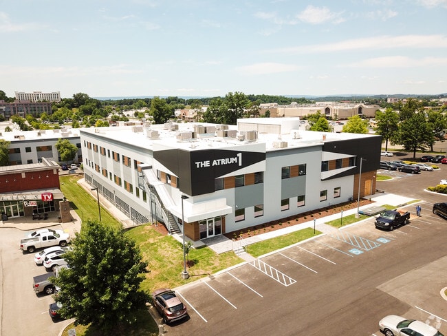
1949 Gunbarrel Rd
Chattanooga, TN-GA
Kelley Frank
149I-A-005
LT 1 FRANK KELLEY TRACT SUB PB 14 PG 35 REV 46-159 REV 72-95 REV 73-11 REV 73-44
Medicalbuilding
Hamilton
X
Tennessee
47065C0368G
1
2025
2.44 AC
2025
Outlying Chattanooga
011446
Chattanooga
46,724 SF
DEMOGRAPHICS near 1949 Gunbarrel Rd
1 Mile
3 Mile
5 Mile
2024 Total Population
6,049
47,053
108,023
2029 Population
6,512
49,949
114,611
Pop Growth 2024-2029
+ 7.65%
+ 6.15%
+ 6.10%
Average Age
41
42
41
2024 Total Households
2,617
19,611
43,723
HH Growth 2024-2029
+ 7.80%
+ 6.36%
+ 6.26%
Median Household Inc
$67,500
$72,003
$66,429
Avg Household Size
2.20
2.30
2.40
2024 Avg HH Vehicles
2.00
2.00
2.00
Median Home Value
$266,708
$247,935
$232,910
Median Year Built
1997
1990
1983
Nearby Places
Map Layers
Map Styles
 Street
 Aerial
- Restaurants
- Banks
- Shops
- Fitness
- Groceries
PUBLIC TRANSPORTATION
AIRPORT
Lovell Field
DRIVE
WALK
Distance
Lovell Field
10 min
5.1 mi
Freight Ports
Georgia Ports - Savannah
DRIVE
WALK
Distance
Georgia Ports - Savannah
1 min
305.8 mi
Nearby Properties
Address
Land Use
TOTAL SIZE
Lot Size
Zoning
Address
Land Use
TOTAL SIZE
Lot Size
Zoning
831.19 AC
M1
Address
Land Use
TOTAL SIZE
Lot Size
Zoning
440,611 SF
27.46 AC
C2
Address
Land Use
TOTAL SIZE
Lot Size
Zoning
292,309 SF
45.28 AC
M1
Address
Land Use
TOTAL SIZE
Lot Size
Zoning
1,015,740 SF
83.82 AC
M1
Address
Land Use
TOTAL SIZE
Lot Size
Zoning
117,007 SF
23.87 AC
R4
Address
Land Use
TOTAL SIZE
Lot Size
Zoning
4,418 SF
18.01 AC
R3
Address
Land Use
TOTAL SIZE
Lot Size
Zoning
320,068 SF
42.83 AC
R4
Address
Land Use
TOTAL SIZE
Lot Size
Zoning
402,862 SF
26.14 AC
R1
Address
Land Use
TOTAL SIZE
Lot Size
Zoning
43,488 SF
27.72 AC
R3
Address
Land Use
TOTAL SIZE
Lot Size
Zoning
25,436 SF
21.34 AC
R3
Address
Land Use
TOTAL SIZE
Lot Size
Zoning
23,078 SF
14.41 AC
R4
Address
Land Use
TOTAL SIZE
Lot Size
Zoning
333,768 SF
15.38 AC
C4
Address
Land Use
TOTAL SIZE
Lot Size
Zoning
43,576 SF
6.66 AC
C2
Address
Land Use
TOTAL SIZE
Lot Size
Zoning
25,462 SF
16.20 AC
R1
Address
Land Use
TOTAL SIZE
Lot Size
Zoning
3,472 SF
14.01 AC
Address
Land Use
TOTAL SIZE
Lot Size
Zoning
20,964 SF
17.72 AC
R1
Address
Land Use
TOTAL SIZE
Lot Size
Zoning
97,000 SF
18.78 AC
Address
Land Use
TOTAL SIZE
Lot Size
Zoning
23,124 SF
27.23 AC
A
Address
Land Use
TOTAL SIZE
Lot Size
Zoning
25,165 SF
21.90 AC
Address
Land Use
TOTAL SIZE
Lot Size
Zoning
102,382 SF
29.80 AC
M2
Address
Land Use
TOTAL SIZE
Lot Size
Zoning
99,202 SF
17.32 AC
Address
Land Use
TOTAL SIZE
Lot Size
Zoning
129,710 SF
4.55 AC
R1
Address
Land Use
TOTAL SIZE
Lot Size
Zoning
201,276 SF
15.30 AC
R3
Address
Land Use
TOTAL SIZE
Lot Size
Zoning
15,808 SF
19.50 AC
R2
Address
Land Use
TOTAL SIZE
Lot Size
Zoning
49,857 SF
1.93 AC
R1
Address
Land Use
TOTAL SIZE
Lot Size
Zoning
50,506 SF
5.14 AC
MD
Address
Land Use
TOTAL SIZE
Lot Size
Zoning
4,390 SF
36.30 AC
R3
Address
Land Use
TOTAL SIZE
Lot Size
Zoning
110,710 SF
6.69 AC
M1
Address
Land Use
TOTAL SIZE
Lot Size
Zoning
238,806 SF
24.84 AC
Address
Land Use
TOTAL SIZE
Lot Size
Zoning
8,032 SF
19.80 AC
The World's #1 Commercial Real Estate Marketplace
Connect with us
© 2026 CoStar Group
The information above has been obtained from sources believed reliable. While we do not doubt its accuracy we have not verified it and make no guarantee, warranty or representation about it. It is your responsibility to independently confirm its accuracy and completeness. Any projections, opinions, assumptions, or estimates used are for example only and do not represent the current or future performance of the property. The value of this transaction to you depends on tax and other factors which should be evaluated by your tax, financial, and legal advisors. You and your advisors should conduct a careful, independent investigation of the property to determine to your satisfaction the suitability of the property for your needs.