Property Record
1949 Lost Mountain Rd, Powder Springs, GA 30127


This Property Is For Sale
NEARBY LISTINGS FOR SALE OR LEASE
Property Detail
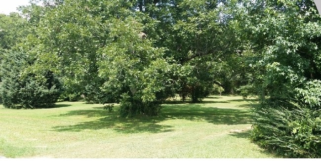
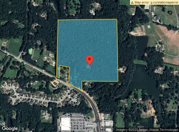
1949 Lost Mountain Rd
Atlanta-Sandy Springs-Roswell, GA
Homesite
19-0386-0-001-0
Cobb
Sfr
Georgia
X
40.58 AC
13067C0091G
Kennesaw/Town Center
2,539 SF
Atlanta
DEMOGRAPHICS near 1949 Lost Mountain Rd
1 Mile
3 Mile
5 Mile
2024 Total Population
2,836
44,185
121,143
2029 Population
2,933
44,896
124,854
Pop Growth 2024-2029
+ 3.42%
+ 1.61%
+ 3.06%
Average Age
42
40
40
2024 Total Households
1,006
14,628
41,508
HH Growth 2024-2029
+ 3.38%
+ 1.62%
+ 3.17%
Median Household Inc
$99,449
$102,995
$97,903
Avg Household Size
2.80
3.00
2.90
2024 Avg HH Vehicles
2.00
2.00
2.00
Median Home Value
$351,159
$347,026
$323,264
Median Year Built
1998
1993
1992
Nearby Places
Map Layers
Map Styles
 Street
 Aerial
- Restaurants
- Banks
- Shops
- Fitness
- Groceries
PUBLIC TRANSPORTATION
AIRPORT
Hartsfield - Jackson Atlanta International
DRIVE
WALK
Distance
Hartsfield - Jackson Atlanta International
51 min
33.5 mi
Freight Ports
Georgia Ports - Savannah
DRIVE
WALK
Distance
Georgia Ports - Savannah
314 min
272.8 mi
Nearby Properties
Address
Land Use
TOTAL SIZE
Lot Size
Zoning
Address
Land Use
TOTAL SIZE
Lot Size
Zoning
Address
Land Use
TOTAL SIZE
Lot Size
Zoning
79,348 SF
12.04 AC
CRC
Address
Land Use
TOTAL SIZE
Lot Size
Zoning
99,972 SF
3.18 AC
NRC/O&I
Address
Land Use
TOTAL SIZE
Lot Size
Zoning
83,054 SF
11.06 AC
NRC/WS
Address
Land Use
TOTAL SIZE
Lot Size
Zoning
101,340 SF
4.24 AC
CRC
Address
Land Use
TOTAL SIZE
Lot Size
Zoning
202,176 SF
24.10 AC
R-30
Address
Land Use
TOTAL SIZE
Lot Size
Zoning
104,746 SF
16.19 AC
CRC/LRO
Address
Land Use
TOTAL SIZE
Lot Size
Zoning
19,059 SF
42.74 AC
R80
Address
Land Use
TOTAL SIZE
Lot Size
Zoning
367,298 SF
15.38 AC
LI
Address
Land Use
TOTAL SIZE
Lot Size
Zoning
72,580 SF
7.05 AC
LI
Address
Land Use
TOTAL SIZE
Lot Size
Zoning
Address
Land Use
TOTAL SIZE
Lot Size
Zoning
87,362 SF
20 AC
LI
Address
Land Use
TOTAL SIZE
Lot Size
Zoning
31,800 SF
6 AC
LI
Address
Land Use
TOTAL SIZE
Lot Size
Zoning
28,812 SF
7.67 AC
LRO
Address
Land Use
TOTAL SIZE
Lot Size
Zoning
8,661 SF
37.47 AC
Address
Land Use
TOTAL SIZE
Lot Size
Zoning
14,314 SF
2.73 AC
Address
Land Use
TOTAL SIZE
Lot Size
Zoning
14,616 SF
2.12 AC
GC
Address
Land Use
TOTAL SIZE
Lot Size
Zoning
18,112 SF
1.37 AC
CRC/LI
Address
Land Use
TOTAL SIZE
Lot Size
Zoning
60,110 SF
3.02 AC
LI
Address
Land Use
TOTAL SIZE
Lot Size
Zoning
15,035 SF
2.31 AC
CRC
Address
Land Use
TOTAL SIZE
Lot Size
Zoning
15,035 SF
2.40 AC
CRC
Address
Land Use
TOTAL SIZE
Lot Size
Zoning
76,500 SF
5.33 AC
LI
Address
Land Use
TOTAL SIZE
Lot Size
Zoning
1,626 SF
10.11 AC
Address
Land Use
TOTAL SIZE
Lot Size
Zoning
48,000 SF
4.11 AC
LI
Address
Land Use
TOTAL SIZE
Lot Size
Zoning
6,713 SF
3.62 AC
GC/WS
Address
Land Use
TOTAL SIZE
Lot Size
Zoning
17,612 SF
1.61 AC
NRC
Address
Land Use
TOTAL SIZE
Lot Size
Zoning
16,612 SF
1.48 AC
LRO/WS
Address
Land Use
TOTAL SIZE
Lot Size
Zoning
37,500 SF
2.80 AC
LI
Address
Land Use
TOTAL SIZE
Lot Size
Zoning
24,000 SF
2.01 AC
LI
Address
Land Use
TOTAL SIZE
Lot Size
Zoning
2,877 SF
60.95 AC
R20
The World's #1 Commercial Real Estate Marketplace
Connect with us
© 2026 CoStar Group
The information above has been obtained from sources believed reliable. While we do not doubt its accuracy we have not verified it and make no guarantee, warranty or representation about it. It is your responsibility to independently confirm its accuracy and completeness. Any projections, opinions, assumptions, or estimates used are for example only and do not represent the current or future performance of the property. The value of this transaction to you depends on tax and other factors which should be evaluated by your tax, financial, and legal advisors. You and your advisors should conduct a careful, independent investigation of the property to determine to your satisfaction the suitability of the property for your needs.