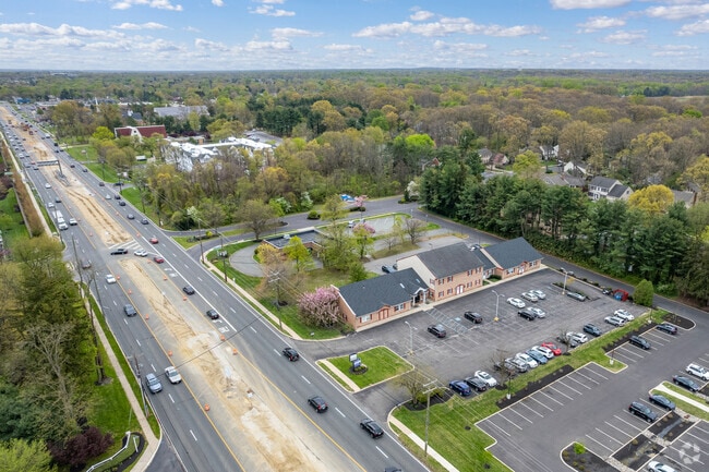
Property Record
1949 Marlton Pike E, Cherry Hill, NJ 08003


Current Lease Availabilities
NEARBY LISTINGS FOR SALE OR LEASE
Property Detail
1949 Marlton Pike E
09-00472-01-00024
Camden
Commercialnec
New Jersey
X
24
34005C0239F
1.03 AC
2024
South Camden County
2025
Philadelphia
603506
Philadelphia-Camden-Wilmington, PA-NJ-DE-MD
DEMOGRAPHICS near 1949 Marlton Pike E
1 Mile
3 Mile
5 Mile
2024 Total Population
9,807
81,557
218,775
2029 Population
9,858
82,020
220,694
Pop Growth 2024-2029
+ 0.52%
+ 0.57%
+ 0.88%
Average Age
41
43
42
2024 Total Households
3,690
31,532
86,241
HH Growth 2024-2029
+ 0.51%
+ 0.64%
+ 0.90%
Median Household Inc
$133,647
$115,844
$108,548
Avg Household Size
2.60
2.50
2.50
2024 Avg HH Vehicles
2.00
2.00
2.00
Median Home Value
$353,897
$340,020
$336,601
Median Year Built
1975
1974
1974
Nearby Places
Map Layers
Map Styles
 Street
 Aerial
- Restaurants
- Banks
- Shops
- Fitness
- Groceries
PUBLIC TRANSPORTATION
COMMUTER RAIL
Lindenwold (NJT) (Atlantic City Line - NJ Transit Commuter Rail (NJ Transit))
DRIVE
WALK
Distance
Lindenwold (NJT) (Atlantic City Line - NJ Transit Commuter Rail (NJ Transit))
14 min
6.2 mi
Cherry Hill (Atlantic City Line - NJ Transit Commuter Rail (NJ Transit))
DRIVE
WALK
Distance
Cherry Hill (Atlantic City Line - NJ Transit Commuter Rail (NJ Transit))
10 min
6.5 mi
AIRPORT
Philadelphia International
DRIVE
WALK
Distance
Philadelphia International
35 min
22.2 mi
Trenton Mercer
DRIVE
WALK
Distance
Trenton Mercer
52 min
37.6 mi
Freight Ports
South Jersey Port
DRIVE
WALK
Distance
South Jersey Port
18 min
10.9 mi
Nearby Properties
Address
Land Use
TOTAL SIZE
Lot Size
Zoning
Address
Land Use
TOTAL SIZE
Lot Size
Zoning
23.82 AC
Address
Land Use
TOTAL SIZE
Lot Size
Zoning
270,246 SF
0.71 AC
RA
Address
Land Use
TOTAL SIZE
Lot Size
Zoning
25,536 SF
18.71 AC
Address
Land Use
TOTAL SIZE
Lot Size
Zoning
44.80 AC
C-1
Address
Land Use
TOTAL SIZE
Lot Size
Zoning
5 AC
C-1
Address
Land Use
TOTAL SIZE
Lot Size
Zoning
52.30 AC
MD
Address
Land Use
TOTAL SIZE
Lot Size
Zoning
Address
Land Use
TOTAL SIZE
Lot Size
Zoning
114,852 SF
12.73 AC
GB2
Address
Land Use
TOTAL SIZE
Lot Size
Zoning
38.13 AC
CP
Address
Land Use
TOTAL SIZE
Lot Size
Zoning
57.50 AC
Address
Land Use
TOTAL SIZE
Lot Size
Zoning
43.20 AC
Address
Land Use
TOTAL SIZE
Lot Size
Zoning
27.83 AC
Address
Land Use
TOTAL SIZE
Lot Size
Zoning
999,999,999 SF
21.10 AC
Address
Land Use
TOTAL SIZE
Lot Size
Zoning
Address
Land Use
TOTAL SIZE
Lot Size
Zoning
122,264 SF
5 AC
RR
Address
Land Use
TOTAL SIZE
Lot Size
Zoning
28.96 AC
Address
Land Use
TOTAL SIZE
Lot Size
Zoning
42.80 AC
MF
Address
Land Use
TOTAL SIZE
Lot Size
Zoning
11.29 AC
Address
Land Use
TOTAL SIZE
Lot Size
Zoning
Address
Land Use
TOTAL SIZE
Lot Size
Zoning
15.10 AC
Address
Land Use
TOTAL SIZE
Lot Size
Zoning
25.28 AC
C-1
Address
Land Use
TOTAL SIZE
Lot Size
Zoning
23.43 AC
INS
Address
Land Use
TOTAL SIZE
Lot Size
Zoning
Address
Land Use
TOTAL SIZE
Lot Size
Zoning
2,264 SF
17.30 AC
C-1
Address
Land Use
TOTAL SIZE
Lot Size
Zoning
Address
Land Use
TOTAL SIZE
Lot Size
Zoning
84.19 AC
Address
Land Use
TOTAL SIZE
Lot Size
Zoning
Address
Land Use
TOTAL SIZE
Lot Size
Zoning
11.73 AC
GB2
Address
Land Use
TOTAL SIZE
Lot Size
Zoning
77,224 SF
7.65 AC
RR
Address
Land Use
TOTAL SIZE
Lot Size
Zoning
10.38 AC
C-1
The World's #1 Commercial Real Estate Marketplace
Connect with us
© 2026 CoStar Group
The information above has been obtained from sources believed reliable. While we do not doubt its accuracy we have not verified it and make no guarantee, warranty or representation about it. It is your responsibility to independently confirm its accuracy and completeness. Any projections, opinions, assumptions, or estimates used are for example only and do not represent the current or future performance of the property. The value of this transaction to you depends on tax and other factors which should be evaluated by your tax, financial, and legal advisors. You and your advisors should conduct a careful, independent investigation of the property to determine to your satisfaction the suitability of the property for your needs.