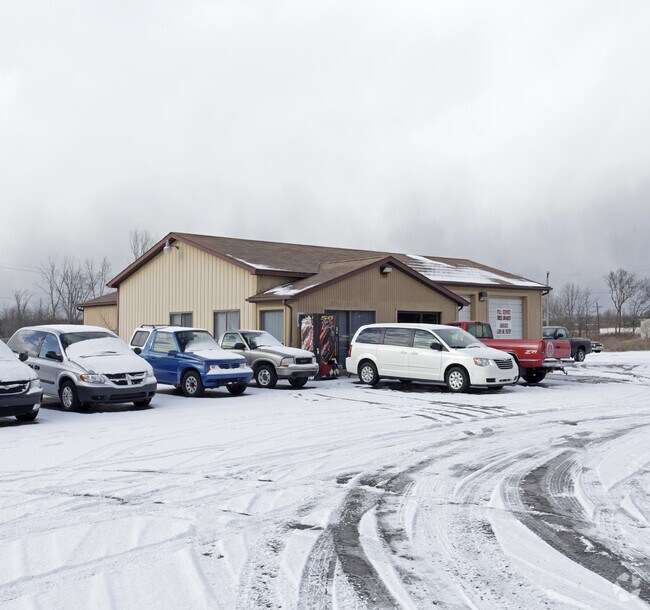
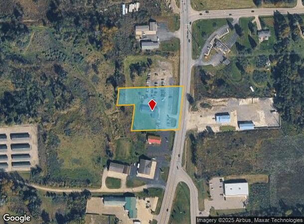
Property Record
1949 N Lapeer Rd, Lapeer, MI 48446

NEARBY LISTINGS FOR SALE OR LEASE
-
-
-
No Photo
-
View all Lapeer listings for sale on LoopNet.com
Property Detail
1949 N Lapeer Rd
014-029-004-10
SEC 29 T8N R10E PART OF THE NE 1/4 OF THE NE 1/4 OF SEC 29 DESC AS BEG AT A PT THAT IS N 89DEG 19'38 W 2.61 FT ALONG THE N
Officebuilding
Lapeer
X
Michigan
26087C0258E
1.76 AC
2024
St Clair & Lapeer Counties
2025
Detroit
334000
Detroit-Warren-Dearborn, MI
1,842 SF
DEMOGRAPHICS near 1949 N Lapeer Rd
1 Mile
3 Mile
5 Mile
2024 Total Population
1,522
13,402
23,272
2029 Population
1,531
13,480
23,368
Pop Growth 2024-2029
+ 0.59%
+ 0.58%
+ 0.41%
Average Age
44
42
43
2024 Total Households
609
5,704
9,646
HH Growth 2024-2029
+ 0.49%
+ 0.58%
+ 0.44%
Median Household Inc
$54,655
$52,066
$61,416
Avg Household Size
2.40
2.30
2.30
2024 Avg HH Vehicles
2.00
2.00
2.00
Median Home Value
$151,212
$154,459
$170,082
Median Year Built
1977
1975
1977
Nearby Places
Map Layers
Map Styles
 Street
 Aerial
- Restaurants
- Banks
- Shops
- Fitness
- Groceries
PUBLIC TRANSPORTATION
COMMUTER RAIL
DRIVE
WALK
Distance
7 min
3.3 mi
AIRPORT
Bishop International
DRIVE
WALK
Distance
Bishop International
46 min
31.4 mi
Nearby Properties
Address
Land Use
TOTAL SIZE
Lot Size
Zoning
Address
Land Use
TOTAL SIZE
Lot Size
Zoning
216,630 SF
33.87 AC
B3 REG
Address
Land Use
TOTAL SIZE
Lot Size
Zoning
184,894 SF
21.97 AC
RM-1 M
Address
Land Use
TOTAL SIZE
Lot Size
Zoning
108.23 AC
MHP
Address
Land Use
TOTAL SIZE
Lot Size
Zoning
672 SF
40 AC
MHP
Address
Land Use
TOTAL SIZE
Lot Size
Zoning
111,975 SF
20 AC
B3 REG
Address
Land Use
TOTAL SIZE
Lot Size
Zoning
240,748 SF
22.20 AC
I1 INDU
Address
Land Use
TOTAL SIZE
Lot Size
Zoning
142,610 SF
35.53 AC
M-2
Address
Land Use
TOTAL SIZE
Lot Size
Zoning
80,728 SF
20 AC
RM-1 M
Address
Land Use
TOTAL SIZE
Lot Size
Zoning
55,270 SF
4.80 AC
R2 1 FM
Address
Land Use
TOTAL SIZE
Lot Size
Zoning
94,442 SF
9 AC
B2 GEN
Address
Land Use
TOTAL SIZE
Lot Size
Zoning
10.32 AC
B2 GEN
Address
Land Use
TOTAL SIZE
Lot Size
Zoning
528 SF
21 AC
MHP
Address
Land Use
TOTAL SIZE
Lot Size
Zoning
17,750 SF
2.34 AC
OS-1
Address
Land Use
TOTAL SIZE
Lot Size
Zoning
5.59 AC
RM-1 M
Address
Land Use
TOTAL SIZE
Lot Size
Zoning
156,950 SF
7.14 AC
I1 INDU
Address
Land Use
TOTAL SIZE
Lot Size
Zoning
95,544 SF
8.39 AC
RM-1 M
Address
Land Use
TOTAL SIZE
Lot Size
Zoning
63,163 SF
6.02 AC
B2 GEN
Address
Land Use
TOTAL SIZE
Lot Size
Zoning
15,565 SF
0.70 AC
I1 INDU
Address
Land Use
TOTAL SIZE
Lot Size
Zoning
3.84 AC
RM-1 M
Address
Land Use
TOTAL SIZE
Lot Size
Zoning
31,914 SF
4.85 AC
B2 GEN
Address
Land Use
TOTAL SIZE
Lot Size
Zoning
48,226 SF
2.71 AC
RM-1 M
Address
Land Use
TOTAL SIZE
Lot Size
Zoning
102,290 SF
6.24 AC
I1 INDU
Address
Land Use
TOTAL SIZE
Lot Size
Zoning
105,560 SF
4.87 AC
I1 INDU
Address
Land Use
TOTAL SIZE
Lot Size
Zoning
29,394 SF
2.82 AC
B2 GEN
Address
Land Use
TOTAL SIZE
Lot Size
Zoning
0.36 AC
CBD1 CEN B
Address
Land Use
TOTAL SIZE
Lot Size
Zoning
61,860 SF
7.02 AC
RM
Address
Land Use
TOTAL SIZE
Lot Size
Zoning
14,894 SF
4.59 AC
C-2
Address
Land Use
TOTAL SIZE
Lot Size
Zoning
13,012 SF
2.24 AC
OS-1
Address
Land Use
TOTAL SIZE
Lot Size
Zoning
27,383 SF
14.39 AC
B2 GEN
Address
Land Use
TOTAL SIZE
Lot Size
Zoning
48,960 SF
1.50 AC
RM-1 M
The World's #1 Commercial Real Estate Marketplace
Connect with us
© 2025 CoStar Group
The information above has been obtained from sources believed reliable. While we do not doubt its accuracy we have not verified it and make no guarantee, warranty or representation about it. It is your responsibility to independently confirm its accuracy and completeness. Any projections, opinions, assumptions, or estimates used are for example only and do not represent the current or future performance of the property. The value of this transaction to you depends on tax and other factors which should be evaluated by your tax, financial, and legal advisors. You and your advisors should conduct a careful, independent investigation of the property to determine to your satisfaction the suitability of the property for your needs.