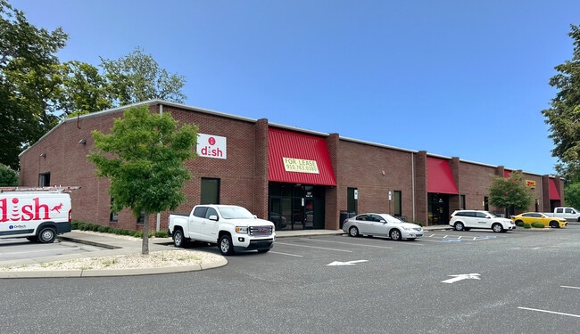
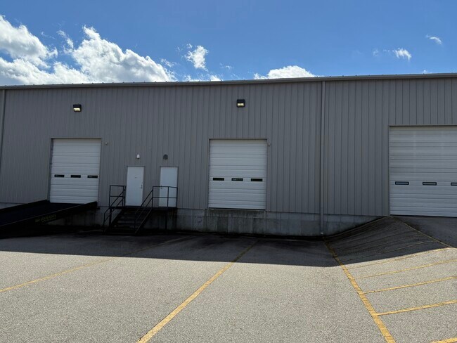
Property Record
195 Airport Rd, Fayetteville, NC 28306

Current Lease Availabilities
NEARBY LISTINGS FOR SALE OR LEASE
Property Detail
195 Airport Rd
Fayetteville, NC
Airport Area (Comm)
0435-23-6911
LT 7 & 207 AIRPORT RD RECOMB SE:01 PL:0134-0151
Warehouse
Cumberland
X
North Carolina
3720043500J
7,207
2025
2.87 AC
2024
East Fayetteville
001603
Fayetteville
24,000 SF
DEMOGRAPHICS near 195 Airport Rd
1 Mile
3 Mile
5 Mile
2024 Total Population
1,467
24,344
80,790
2029 Population
1,464
24,388
80,956
Pop Growth 2024-2029
(0.20%)
+ 0.18%
+ 0.21%
Average Age
40
37
38
2024 Total Households
615
9,617
32,780
HH Growth 2024-2029
(0.33%)
+ 0.17%
+ 0.23%
Median Household Inc
$46,736
$49,798
$51,079
Avg Household Size
2.30
2.50
2.40
2024 Avg HH Vehicles
2.00
2.00
2.00
Median Home Value
$137,559
$149,171
$153,098
Median Year Built
1984
1990
1982
Nearby Places
Map Layers
Map Styles
 Street
 Aerial
- Restaurants
- Banks
- Shops
- Fitness
- Groceries
PUBLIC TRANSPORTATION
COMMUTER RAIL
Fayetteville Amtrak Station (Palmetto - Amtrak, Silver Meteor - Amtrak)
DRIVE
WALK
Distance
Fayetteville Amtrak Station (Palmetto - Amtrak, Silver Meteor - Amtrak)
7 min
4.9 mi
AIRPORT
Fayetteville Regional/Grannis Field
DRIVE
WALK
Distance
Fayetteville Regional/Grannis Field
2 min
0.7 mi
Freight Ports
Port of Wilmington
DRIVE
WALK
Distance
Port of Wilmington
126 min
89.5 mi
Nearby Properties
Address
Land Use
TOTAL SIZE
Lot Size
Zoning
Address
Land Use
TOTAL SIZE
Lot Size
Zoning
47,832 SF
43.28 AC
CC
Address
Land Use
TOTAL SIZE
Lot Size
Zoning
1,377 SF
20.14 AC
MR5-MIXED
Address
Land Use
TOTAL SIZE
Lot Size
Zoning
4,947 SF
937.13 AC
MA
Address
Land Use
TOTAL SIZE
Lot Size
Zoning
28,107 SF
34.33 AC
HI
Address
Land Use
TOTAL SIZE
Lot Size
Zoning
56,622 SF
104.70 AC
R10
Address
Land Use
TOTAL SIZE
Lot Size
Zoning
14,000 SF
97.50 AC
MP
Address
Land Use
TOTAL SIZE
Lot Size
Zoning
191,495 SF
21.41 AC
CC
Address
Land Use
TOTAL SIZE
Lot Size
Zoning
1,823 SF
4.02 AC
R5A
Address
Land Use
TOTAL SIZE
Lot Size
Zoning
94,791 SF
18.04 AC
HI
Address
Land Use
TOTAL SIZE
Lot Size
Zoning
49.27 AC
MP-PLND IN
Address
Land Use
TOTAL SIZE
Lot Size
Zoning
3,480 SF
21.10 AC
MR5
Address
Land Use
TOTAL SIZE
Lot Size
Zoning
77,650 SF
47.37 AC
CC
Address
Land Use
TOTAL SIZE
Lot Size
Zoning
88,383 SF
13.30 AC
CC
Address
Land Use
TOTAL SIZE
Lot Size
Zoning
365,607 SF
59.08 AC
HI
Address
Land Use
TOTAL SIZE
Lot Size
Zoning
23,322 SF
32.40 AC
HI
Address
Land Use
TOTAL SIZE
Lot Size
Zoning
35,242 SF
56.61 AC
MP
Address
Land Use
TOTAL SIZE
Lot Size
Zoning
2,347 SF
7.22 AC
R5A
Address
Land Use
TOTAL SIZE
Lot Size
Zoning
9,404 SF
62.05 AC
RR
Address
Land Use
TOTAL SIZE
Lot Size
Zoning
1,970 SF
5.04 AC
R5A
Address
Land Use
TOTAL SIZE
Lot Size
Zoning
21.10 AC
MP
Address
Land Use
TOTAL SIZE
Lot Size
Zoning
136,504 SF
18.74 AC
HI
Address
Land Use
TOTAL SIZE
Lot Size
Zoning
5,050 SF
4.31 AC
LI
Address
Land Use
TOTAL SIZE
Lot Size
Zoning
2,636 SF
14.81 AC
R5A
Address
Land Use
TOTAL SIZE
Lot Size
Zoning
16.41 AC
MP
Address
Land Use
TOTAL SIZE
Lot Size
Zoning
1,935 SF
10.99 AC
MR5
Address
Land Use
TOTAL SIZE
Lot Size
Zoning
62,768 SF
5.22 AC
C2PCZ
Address
Land Use
TOTAL SIZE
Lot Size
Zoning
32,893 SF
5.60 AC
CC
Address
Land Use
TOTAL SIZE
Lot Size
Zoning
5,880 SF
6.87 AC
SF6
Address
Land Use
TOTAL SIZE
Lot Size
Zoning
1,969 SF
3.95 AC
R5
Address
Land Use
TOTAL SIZE
Lot Size
Zoning
1,823 SF
4.27 AC
R5
The World's #1 Commercial Real Estate Marketplace
Connect with us
© 2025 CoStar Group
The information above has been obtained from sources believed reliable. While we do not doubt its accuracy we have not verified it and make no guarantee, warranty or representation about it. It is your responsibility to independently confirm its accuracy and completeness. Any projections, opinions, assumptions, or estimates used are for example only and do not represent the current or future performance of the property. The value of this transaction to you depends on tax and other factors which should be evaluated by your tax, financial, and legal advisors. You and your advisors should conduct a careful, independent investigation of the property to determine to your satisfaction the suitability of the property for your needs.