Property Record
195 Andover St, Andover, MA 01810
NEARBY LISTINGS FOR SALE OR LEASE
Property Detail
195 Andover St
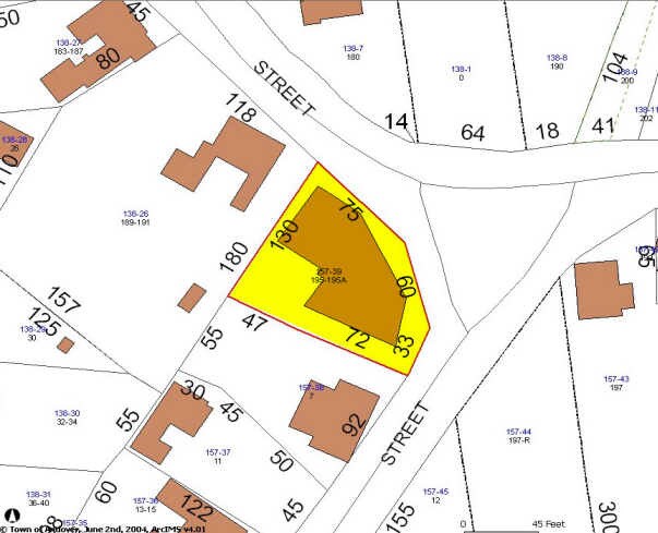
ANDO-000157-000039
Andover
Storebuilding
Essex
X
Massachusetts
25009C0218G
0.22 AC
2024
Lawrence/Andover
2024
Boston
254403
Boston-Cambridge-Newton, MA-NH
7,933 SF
DEMOGRAPHICS near 195 Andover St
1 Mile
3 Mile
5 Mile
2024 Total Population
3,939
31,438
127,110
2029 Population
3,935
31,361
126,012
Pop Growth 2024-2029
(0.10%)
(0.24%)
(0.86%)
Average Age
41
42
40
2024 Total Households
1,270
11,402
45,338
HH Growth 2024-2029
(0.24%)
(0.36%)
(0.92%)
Median Household Inc
$191,703
$149,151
$114,925
Avg Household Size
3.00
2.60
2.70
2024 Avg HH Vehicles
2.00
2.00
2.00
Median Home Value
$766,933
$724,046
$620,289
Median Year Built
1975
1971
1973
Nearby Places
Map Layers
Map Styles
 Street
 Aerial
- Restaurants
- Banks
- Shops
- Fitness
- Groceries
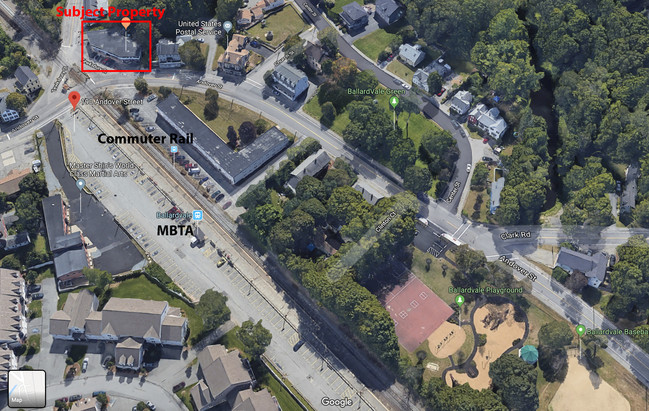
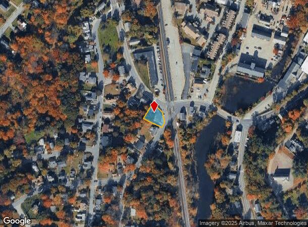
PUBLIC TRANSPORTATION
TRANSIT/SUBWAY
Ballardvale (Haverhill Line - Massachusetts Bay Transportation Authority Commuter Rail (Purple Line))
DRIVE
WALK
Distance
Ballardvale (Haverhill Line - Massachusetts Bay Transportation Authority Commuter Rail (Purple Line))
1 min
2 min
0.1 mi
COMMUTER RAIL
Ballardvale (Haverhill Line - Massachusetts Bay Transportation Authority Commuter Rail (Purple Line))
DRIVE
WALK
Distance
Ballardvale (Haverhill Line - Massachusetts Bay Transportation Authority Commuter Rail (Purple Line))
1 min
2 min
0.1 mi
Andover (Haverhill Line - Massachusetts Bay Transportation Authority Commuter Rail (Purple Line))
DRIVE
WALK
Distance
Andover (Haverhill Line - Massachusetts Bay Transportation Authority Commuter Rail (Purple Line))
7 min
2.9 mi
AIRPORT
General Edward Lawrence Logan International
DRIVE
WALK
Distance
General Edward Lawrence Logan International
35 min
23.6 mi
Manchester Boston Regional
DRIVE
WALK
Distance
Manchester Boston Regional
48 min
32.0 mi
Portsmouth International at Pease
DRIVE
WALK
Distance
Portsmouth International at Pease
58 min
42.6 mi
Freight Ports
Port of Boston
DRIVE
WALK
Distance
Port of Boston
36 min
23.3 mi
SALE & LEASE HISTORY
LISTING DATE
SALE/LEASE

Sep 25, 2016
For Lease
Nov 11, 2019
For Sale
Aug 04, 2017
For Sale
Nearby Properties
Address
Land Use
TOTAL SIZE
Lot Size
Zoning
Address
Land Use
TOTAL SIZE
Lot Size
Zoning
0.24 AC
SRC
Address
Land Use
TOTAL SIZE
Lot Size
Zoning
44.42 AC
LS
Address
Land Use
TOTAL SIZE
Lot Size
Zoning
341,215 SF
16.94 AC
IND
Address
Land Use
TOTAL SIZE
Lot Size
Zoning
591,906 SF
153.43 AC
IA
Address
Land Use
TOTAL SIZE
Lot Size
Zoning
314,278 SF
595.78 AC
SRB
Address
Land Use
TOTAL SIZE
Lot Size
Zoning
263.15 AC
SRB
Address
Land Use
TOTAL SIZE
Lot Size
Zoning
509.76 AC
IA
Address
Land Use
TOTAL SIZE
Lot Size
Zoning
308.52 AC
IA
Address
Land Use
TOTAL SIZE
Lot Size
Zoning
343,105 SF
60.18 AC
IND
Address
Land Use
TOTAL SIZE
Lot Size
Zoning
140,376 SF
2,026.22 AC
SRB
Address
Land Use
TOTAL SIZE
Lot Size
Zoning
221,927 SF
27.88 AC
IND
Address
Land Use
TOTAL SIZE
Lot Size
Zoning
0.13 AC
MU
Address
Land Use
TOTAL SIZE
Lot Size
Zoning
193.30 AC
IA
Address
Land Use
TOTAL SIZE
Lot Size
Zoning
447,869 SF
27.06 AC
ID
Address
Land Use
TOTAL SIZE
Lot Size
Zoning
14 AC
SRB
Address
Land Use
TOTAL SIZE
Lot Size
Zoning
224.38 AC
SRB
Address
Land Use
TOTAL SIZE
Lot Size
Zoning
484,857 SF
42.05 AC
HI
Address
Land Use
TOTAL SIZE
Lot Size
Zoning
150,000 SF
30.73 AC
LS
Address
Land Use
TOTAL SIZE
Lot Size
Zoning
129,522 SF
20.22 AC
SRB
Address
Land Use
TOTAL SIZE
Lot Size
Zoning
9.80 AC
R40
Address
Land Use
TOTAL SIZE
Lot Size
Zoning
180,640 SF
16.24 AC
ID2
Address
Land Use
TOTAL SIZE
Lot Size
Zoning
26.32 AC
IA
Address
Land Use
TOTAL SIZE
Lot Size
Zoning
30,240 SF
5.78 AC
LS
Address
Land Use
TOTAL SIZE
Lot Size
Zoning
81,975 SF
9.37 AC
SRB
Address
Land Use
TOTAL SIZE
Lot Size
Zoning
133,877 SF
16.30 AC
IND
Address
Land Use
TOTAL SIZE
Lot Size
Zoning
146,728 SF
0.17 AC
MU
Address
Land Use
TOTAL SIZE
Lot Size
Zoning
112,330 SF
17.06 AC
IA
Address
Land Use
TOTAL SIZE
Lot Size
Zoning
167,654 SF
14.84 AC
GI
Address
Land Use
TOTAL SIZE
Lot Size
Zoning
120,682 SF
12.03 AC
ID2
Address
Land Use
TOTAL SIZE
Lot Size
Zoning
123,700 SF
9.43 AC
The World's #1 Commercial Real Estate Marketplace
Connect with us
© 2025 CoStar Group
The information above has been obtained from sources believed reliable. While we do not doubt its accuracy we have not verified it and make no guarantee, warranty or representation about it. It is your responsibility to independently confirm its accuracy and completeness. Any projections, opinions, assumptions, or estimates used are for example only and do not represent the current or future performance of the property. The value of this transaction to you depends on tax and other factors which should be evaluated by your tax, financial, and legal advisors. You and your advisors should conduct a careful, independent investigation of the property to determine to your satisfaction the suitability of the property for your needs.