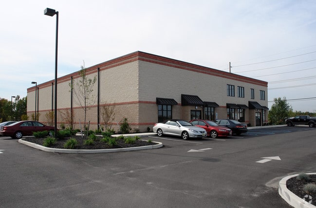
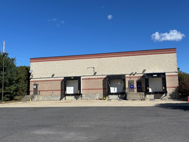
Property Record
195 Borrelli Blvd, Paulsboro, NJ 08066


Current Lease Availabilities
Property Detail
195 Borrelli Blvd
03-00302-0000-00003
ALSO LOT P/O LOT 4.1 8
Warehouse
GLOUCESTER
B1
New Jersey
B and X Area of moderate flood hazard, usually the area between the limits of the 100-year and 500-year floods.
3
2024
8.65 AC
2025
Gloucester County
500601
Philadelphia
12,737 SF
Philadelphia-Camden-Wilmington, PA-NJ-DE-MD
NEARBY LISTINGS FOR SALE OR LEASE
DEMOGRAPHICS near 195 Borrelli Blvd
1 mile
3 mile
5 mile
2025 Total Population
4,476
27,028
78,769
2030 Population
4,621
27,804
80,817
Pop Growth 2025-2030
+ 3.24%
+ 2.87%
+ 2.60%
Average Age
39
41
41
2025 Total Households
1,743
10,607
30,487
HH Growth 2025-2030
+ 3.21%
+ 2.87%
+ 2.66%
Median Household Inc
$82,988
$91,581
$94,564
Avg Household Size
2.50
2.50
2.50
2025 Avg HH Vehicles
2.00
2.00
2.00
Median Home Value
$266,617
$332,467
$295,309
Median Year Built
1963
1974
1970
Nearby Places
Map Layers
Map Styles
 Street
 Aerial
Layers
 Traffic
 Biking
Places
Listings with unknown addresses are not visible on the map
- Restaurants
- Banks
- Shops
- Fitness
- Groceries
PUBLIC TRANSPORTATION
AIRPORT
Philadelphia International
Drive
Walk
Distance
Philadelphia International
29 min
18.6 mi
Trenton Mercer
Drive
Walk
Distance
Trenton Mercer
66 min
47.3 mi
Freight Ports
Broadway Terminal - Pier 5
Drive
Walk
Distance
Broadway Terminal - Pier 5
16 min
10.0 mi
Nearby Properties
Address
Land Use
TOTAL SIZE
Lot Size
Zoning
Address
Land Use
TOTAL SIZE
Lot Size
Zoning
653.90 AC
Address
Land Use
TOTAL SIZE
Lot Size
Zoning
69.05 AC
M2
Address
Land Use
TOTAL SIZE
Lot Size
Zoning
71.49 AC
Address
Land Use
TOTAL SIZE
Lot Size
Zoning
243.55 AC
M2
Address
Land Use
TOTAL SIZE
Lot Size
Zoning
111.06 AC
MIBP
Address
Land Use
TOTAL SIZE
Lot Size
Zoning
47.40 AC
C2
Address
Land Use
TOTAL SIZE
Lot Size
Zoning
Address
Land Use
TOTAL SIZE
Lot Size
Zoning
53.18 AC
M2
Address
Land Use
TOTAL SIZE
Lot Size
Zoning
40.25 AC
M
Address
Land Use
TOTAL SIZE
Lot Size
Zoning
73.82 AC
M
Address
Land Use
TOTAL SIZE
Lot Size
Zoning
34.58 AC
Address
Land Use
TOTAL SIZE
Lot Size
Zoning
32.88 AC
M1
Address
Land Use
TOTAL SIZE
Lot Size
Zoning
Address
Land Use
TOTAL SIZE
Lot Size
Zoning
Address
Land Use
TOTAL SIZE
Lot Size
Zoning
22.60 AC
R4
Address
Land Use
TOTAL SIZE
Lot Size
Zoning
Address
Land Use
TOTAL SIZE
Lot Size
Zoning
38.17 AC
R4
Address
Land Use
TOTAL SIZE
Lot Size
Zoning
24.27 AC
M2
Address
Land Use
TOTAL SIZE
Lot Size
Zoning
55.38 AC
M2
Address
Land Use
TOTAL SIZE
Lot Size
Zoning
111.40 AC
RRC
Address
Land Use
TOTAL SIZE
Lot Size
Zoning
36.52 AC
M1
Address
Land Use
TOTAL SIZE
Lot Size
Zoning
31 AC
M1
Address
Land Use
TOTAL SIZE
Lot Size
Zoning
302.82 AC
M2
Address
Land Use
TOTAL SIZE
Lot Size
Zoning
19.34 AC
R1
Address
Land Use
TOTAL SIZE
Lot Size
Zoning
27.18 AC
M1
Address
Land Use
TOTAL SIZE
Lot Size
Zoning
30.76 AC
BP
Address
Land Use
TOTAL SIZE
Lot Size
Zoning
30.23 AC
Address
Land Use
TOTAL SIZE
Lot Size
Zoning
5.72 AC
R3
Address
Land Use
TOTAL SIZE
Lot Size
Zoning
5 AC
R1
Address
Land Use
TOTAL SIZE
Lot Size
Zoning
4.47 AC
MU
The World's #1 Commercial Real Estate Marketplace
Connect with us
© 2026 CoStar Group
The information above has been obtained from sources believed reliable. While we do not doubt its accuracy we have not verified it and make no guarantee, warranty or representation about it. It is your responsibility to independently confirm its accuracy and completeness. Any projections, opinions, assumptions, or estimates used are for example only and do not represent the current or future performance of the property. The value of this transaction to you depends on tax and other factors which should be evaluated by your tax, financial, and legal advisors. You and your advisors should conduct a careful, independent investigation of the property to determine to your satisfaction the suitability of the property for your needs.