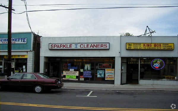
Property Record
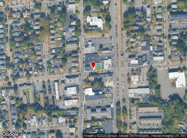
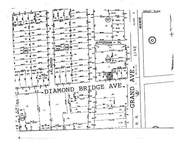
195 Diamond Bridge Ave, Hawthorne, NJ 07506
NEARBY LISTINGS FOR SALE OR LEASE
Property Detail
195 Diamond Bridge Ave
04-00106-0000-00011
Passaic
Storemultistory
New Jersey
X
11
34031C0209G
0.08 AC
2024
Route 208 Corridor
2025
Northern New Jersey
143202
New York-Jersey City-White Plains, NY-NJ
DEMOGRAPHICS near 195 Diamond Bridge Ave
1 Mile
3 Mile
5 Mile
2024 Total Population
18,835
220,072
429,958
2029 Population
18,146
213,255
418,886
Pop Growth 2024-2029
(3.66%)
(3.10%)
(2.58%)
Average Age
40
38
40
2024 Total Households
6,919
72,615
144,452
HH Growth 2024-2029
(3.82%)
(3.17%)
(2.67%)
Median Household Inc
$90,609
$72,964
$87,292
Avg Household Size
2.60
2.90
2.90
2024 Avg HH Vehicles
2.00
2.00
2.00
Median Home Value
$460,645
$469,680
$498,332
Median Year Built
1949
1952
1955
Nearby Places
Map Layers
Map Styles
 Street
 Aerial
- Restaurants
- Banks
- Shops
- Fitness
- Groceries
PUBLIC TRANSPORTATION
TRANSIT/SUBWAY
Hawthorne (Main/Port Jervis Line - NJ Transit Commuter Rail (NJ Transit))
DRIVE
WALK
Distance
Hawthorne (Main/Port Jervis Line - NJ Transit Commuter Rail (NJ Transit))
2 min
11 min
0.6 mi
COMMUTER RAIL
Hawthorne (Main/Port Jervis Line - NJ Transit Commuter Rail (NJ Transit))
DRIVE
WALK
Distance
Hawthorne (Main/Port Jervis Line - NJ Transit Commuter Rail (NJ Transit))
2 min
11 min
0.6 mi
Glen Rock Boro Hall (Bergen County/Port Jervis Line - NJ Transit Commuter Rail (NJ Transit))
DRIVE
WALK
Distance
Glen Rock Boro Hall (Bergen County/Port Jervis Line - NJ Transit Commuter Rail (NJ Transit))
6 min
2.1 mi
AIRPORT
Newark Liberty International
DRIVE
WALK
Distance
Newark Liberty International
31 min
23.5 mi
LaGuardia
DRIVE
WALK
Distance
LaGuardia
39 min
24.2 mi
Westchester County
DRIVE
WALK
Distance
Westchester County
59 min
42.5 mi
Freight Ports
Maher Terminal
DRIVE
WALK
Distance
Maher Terminal
37 min
23.7 mi
Nearby Properties
Address
Land Use
TOTAL SIZE
Lot Size
Zoning
Address
Land Use
TOTAL SIZE
Lot Size
Zoning
45,000 SF
124.04 AC
R-A
Address
Land Use
TOTAL SIZE
Lot Size
Zoning
61.98 AC
Address
Land Use
TOTAL SIZE
Lot Size
Zoning
79,310 SF
2 AC
B-2
Address
Land Use
TOTAL SIZE
Lot Size
Zoning
9.96 AC
MU
Address
Land Use
TOTAL SIZE
Lot Size
Zoning
57,680 SF
20.01 AC
CR
Address
Land Use
TOTAL SIZE
Lot Size
Zoning
84.08 AC
Address
Land Use
TOTAL SIZE
Lot Size
Zoning
7.83 AC
Address
Land Use
TOTAL SIZE
Lot Size
Zoning
1.80 AC
Address
Land Use
TOTAL SIZE
Lot Size
Zoning
Address
Land Use
TOTAL SIZE
Lot Size
Zoning
19.20 AC
Address
Land Use
TOTAL SIZE
Lot Size
Zoning
824,024 SF
39.71 AC
I1
Address
Land Use
TOTAL SIZE
Lot Size
Zoning
90.48 AC
Address
Land Use
TOTAL SIZE
Lot Size
Zoning
Address
Land Use
TOTAL SIZE
Lot Size
Zoning
5.88 AC
Address
Land Use
TOTAL SIZE
Lot Size
Zoning
1,482 SF
55.66 AC
R-B
Address
Land Use
TOTAL SIZE
Lot Size
Zoning
59.45 AC
R100
Address
Land Use
TOTAL SIZE
Lot Size
Zoning
27.25 AC
Address
Land Use
TOTAL SIZE
Lot Size
Zoning
Address
Land Use
TOTAL SIZE
Lot Size
Zoning
2.67 AC
AH2
Address
Land Use
TOTAL SIZE
Lot Size
Zoning
0.12 AC
Address
Land Use
TOTAL SIZE
Lot Size
Zoning
220,994 SF
16.48 AC
Address
Land Use
TOTAL SIZE
Lot Size
Zoning
192,252 SF
5 AC
Address
Land Use
TOTAL SIZE
Lot Size
Zoning
183,072 SF
5.50 AC
Address
Land Use
TOTAL SIZE
Lot Size
Zoning
269,236 SF
10 AC
Address
Land Use
TOTAL SIZE
Lot Size
Zoning
140,626 SF
3.28 AC
B-2
Address
Land Use
TOTAL SIZE
Lot Size
Zoning
21.82 AC
Address
Land Use
TOTAL SIZE
Lot Size
Zoning
11.89 AC
Address
Land Use
TOTAL SIZE
Lot Size
Zoning
3.58 AC
Address
Land Use
TOTAL SIZE
Lot Size
Zoning
186,299 SF
2.16 AC
R-A
Address
Land Use
TOTAL SIZE
Lot Size
Zoning
9.23 AC
The World's #1 Commercial Real Estate Marketplace
Connect with us
© 2025 CoStar Group
The information above has been obtained from sources believed reliable. While we do not doubt its accuracy we have not verified it and make no guarantee, warranty or representation about it. It is your responsibility to independently confirm its accuracy and completeness. Any projections, opinions, assumptions, or estimates used are for example only and do not represent the current or future performance of the property. The value of this transaction to you depends on tax and other factors which should be evaluated by your tax, financial, and legal advisors. You and your advisors should conduct a careful, independent investigation of the property to determine to your satisfaction the suitability of the property for your needs.