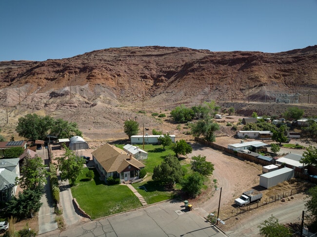
Property Record
195 E 200 N, Moab, UT 84532


Property Detail
195 E 200 N
01-0001-0038
BEG 462 FT W AND 33 FT N OF THE NE COR OF BLOCK 22 MOAB TOWNSITE AND PROCEEDING; THENCE N 66 FT; THENCE W 107.84 FT TO THE BI
Realpropertynec
Grand
B and X Area of moderate flood hazard, usually the area between the limits of the 100-year and 500-year floods.
Utah
2025
2.07 AC
2025
Moab
000200
Other Market Areas
1,593 SF
NEARBY LISTINGS FOR SALE OR LEASE
DEMOGRAPHICS near 195 E 200 N
1 mile
3 mile
5 mile
2025 Total Population
3,772
6,281
8,237
2030 Population
3,759
6,240
8,292
Pop Growth 2025-2030
(0.34%)
(0.65%)
+ 0.67%
Average Age
39
40
41
2025 Total Households
1,574
2,604
3,431
HH Growth 2025-2030
(0.19%)
(0.50%)
+ 0.82%
Median Household Inc
$51,170
$55,944
$62,732
Avg Household Size
2.40
2.40
2.40
2025 Avg HH Vehicles
2.00
2.00
2.00
Median Home Value
$616,606
$574,733
$592,183
Median Year Built
1976
1979
1989
Nearby Places
Map Layers
Map Styles
 Street
 Aerial
Transit
 Traffic
 Biking
Places
Listings with unknown addresses are not visible on the map
- Restaurants
- Banks
- Shops
- Fitness
- Groceries
SALE & LEASE HISTORY
LISTING DATE
SALE/LEASE

Dec 01, 2022
For Sale
Nearby Properties
Address
Land Use
TOTAL SIZE
Lot Size
Zoning
Address
Land Use
TOTAL SIZE
Lot Size
Zoning
Address
Land Use
TOTAL SIZE
Lot Size
Zoning
Address
Land Use
TOTAL SIZE
Lot Size
Zoning
5.23 AC
Address
Land Use
TOTAL SIZE
Lot Size
Zoning
33.88 AC
Address
Land Use
TOTAL SIZE
Lot Size
Zoning
62,319 SF
4.85 AC
Address
Land Use
TOTAL SIZE
Lot Size
Zoning
68,110 SF
1.38 AC
Address
Land Use
TOTAL SIZE
Lot Size
Zoning
Address
Land Use
TOTAL SIZE
Lot Size
Zoning
78,548 SF
1.26 AC
Address
Land Use
TOTAL SIZE
Lot Size
Zoning
8,500 SF
21.32 AC
Address
Land Use
TOTAL SIZE
Lot Size
Zoning
59,086 SF
2.65 AC
Address
Land Use
TOTAL SIZE
Lot Size
Zoning
59,032 SF
5 AC
Address
Land Use
TOTAL SIZE
Lot Size
Zoning
1,391 SF
9.40 AC
Address
Land Use
TOTAL SIZE
Lot Size
Zoning
5,875 SF
2.25 AC
Address
Land Use
TOTAL SIZE
Lot Size
Zoning
2,205 SF
39.56 AC
Address
Land Use
TOTAL SIZE
Lot Size
Zoning
51,795 SF
1.26 AC
Address
Land Use
TOTAL SIZE
Lot Size
Zoning
58,355 SF
2.58 AC
Address
Land Use
TOTAL SIZE
Lot Size
Zoning
72,946 SF
3.34 AC
Address
Land Use
TOTAL SIZE
Lot Size
Zoning
2,863 SF
4.73 AC
Address
Land Use
TOTAL SIZE
Lot Size
Zoning
51,056 SF
3.04 AC
Address
Land Use
TOTAL SIZE
Lot Size
Zoning
57,094 SF
2.44 AC
Address
Land Use
TOTAL SIZE
Lot Size
Zoning
56,316 SF
1.85 AC
Address
Land Use
TOTAL SIZE
Lot Size
Zoning
1,016 SF
2.67 AC
Address
Land Use
TOTAL SIZE
Lot Size
Zoning
546 SF
6.33 AC
Address
Land Use
TOTAL SIZE
Lot Size
Zoning
0.63 AC
Address
Land Use
TOTAL SIZE
Lot Size
Zoning
7.02 AC
Address
Land Use
TOTAL SIZE
Lot Size
Zoning
32,623 SF
1.49 AC
Address
Land Use
TOTAL SIZE
Lot Size
Zoning
51,005 SF
4.58 AC
Address
Land Use
TOTAL SIZE
Lot Size
Zoning
34.06 AC
Address
Land Use
TOTAL SIZE
Lot Size
Zoning
0.77 AC
Address
Land Use
TOTAL SIZE
Lot Size
Zoning
24,593 SF
1.63 AC
The World's #1 Commercial Real Estate Marketplace
Connect with us
© 2026 CoStar Group
The information above has been obtained from sources believed reliable. While we do not doubt its accuracy we have not verified it and make no guarantee, warranty or representation about it. It is your responsibility to independently confirm its accuracy and completeness. Any projections, opinions, assumptions, or estimates used are for example only and do not represent the current or future performance of the property. The value of this transaction to you depends on tax and other factors which should be evaluated by your tax, financial, and legal advisors. You and your advisors should conduct a careful, independent investigation of the property to determine to your satisfaction the suitability of the property for your needs.