Property Record
195 Eastern Ave, Manchester, NH 03104


Save to a Folder
{{folder.Name}}
{{folder.ListingIds.length}} Properties
{{folder.ListingIds.length}} Property
Create a New Folder
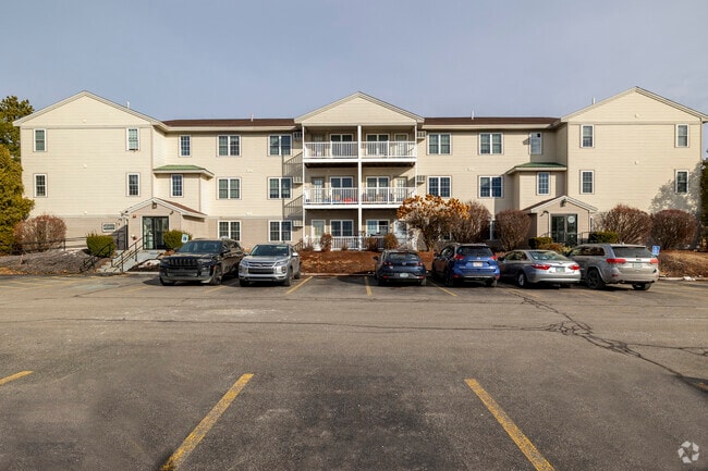
Property Detail
195 Eastern Ave
MNCH-000645A-000000-000003
Hillsborough
Apartment
New Hampshire
B and X Area of moderate flood hazard, usually the area between the limits of the 100-year and 500-year floods.
3
2024
5.50 AC
2024
Wellington Manchester
000902
Boston
28,888 SF
Manchester-Nashua, NH
NEARBY LISTINGS FOR SALE OR LEASE
DEMOGRAPHICS near 195 Eastern Ave
1 mile
3 mile
5 mile
2025 Total Population
9,314
75,168
131,561
2030 Population
9,424
75,546
132,631
Pop Growth 2025-2030
+ 1.18%
+ 0.50%
+ 0.81%
Average Age
42
40
40
2025 Total Households
3,929
31,465
54,670
HH Growth 2025-2030
+ 1.27%
+ 0.59%
+ 0.87%
Median Household Inc
$105,519
$86,791
$87,305
Avg Household Size
2.30
2.20
2.30
2025 Avg HH Vehicles
2.00
2.00
2.00
Median Home Value
$377,818
$382,183
$384,085
Median Year Built
1983
1960
1969
Nearby Places
Map Layers
Map Styles
 Street
 Aerial
Layers
 Traffic
 Biking
Places
Listings with unknown addresses are not visible on the map
- Restaurants
- Banks
- Shops
- Fitness
- Groceries
PUBLIC TRANSPORTATION
AIRPORT
Manchester Boston Regional
Drive
Walk
Distance
Manchester Boston Regional
21 min
9.5 mi
Freight Ports
Port of Boston
Drive
Walk
Distance
Port of Boston
85 min
54.9 mi
Nearby Properties
Address
Land Use
TOTAL SIZE
Lot Size
Zoning
Address
Land Use
TOTAL SIZE
Lot Size
Zoning
446,957 SF
24.16 AC
Address
Land Use
TOTAL SIZE
Lot Size
Zoning
6,830 SF
17.24 AC
Address
Land Use
TOTAL SIZE
Lot Size
Zoning
256,041 SF
6.69 AC
Address
Land Use
TOTAL SIZE
Lot Size
Zoning
135,686 SF
30.23 AC
Address
Land Use
TOTAL SIZE
Lot Size
Zoning
46,906 SF
552.35 AC
Address
Land Use
TOTAL SIZE
Lot Size
Zoning
250,905 SF
1.16 AC
Address
Land Use
TOTAL SIZE
Lot Size
Zoning
217,697 SF
43.25 AC
Address
Land Use
TOTAL SIZE
Lot Size
Zoning
229,089 SF
3.58 AC
Address
Land Use
TOTAL SIZE
Lot Size
Zoning
135,879 SF
2.36 AC
Address
Land Use
TOTAL SIZE
Lot Size
Zoning
8,064 SF
33.49 AC
Address
Land Use
TOTAL SIZE
Lot Size
Zoning
398,130 SF
1.68 AC
Address
Land Use
TOTAL SIZE
Lot Size
Zoning
49,788 SF
34.73 AC
Address
Land Use
TOTAL SIZE
Lot Size
Zoning
237,634 SF
5.39 AC
Address
Land Use
TOTAL SIZE
Lot Size
Zoning
24,064 SF
19.44 AC
Address
Land Use
TOTAL SIZE
Lot Size
Zoning
16,000 SF
58.17 AC
Address
Land Use
TOTAL SIZE
Lot Size
Zoning
211,525 SF
93.01 AC
Address
Land Use
TOTAL SIZE
Lot Size
Zoning
181,610 SF
0.58 AC
Address
Land Use
TOTAL SIZE
Lot Size
Zoning
165,000 SF
3.38 AC
Address
Land Use
TOTAL SIZE
Lot Size
Zoning
230,582 SF
0.31 AC
Address
Land Use
TOTAL SIZE
Lot Size
Zoning
2,218 SF
17.11 AC
Address
Land Use
TOTAL SIZE
Lot Size
Zoning
148,880 SF
2.38 AC
Address
Land Use
TOTAL SIZE
Lot Size
Zoning
264,671 SF
4.04 AC
Address
Land Use
TOTAL SIZE
Lot Size
Zoning
Address
Land Use
TOTAL SIZE
Lot Size
Zoning
8,318 SF
8.71 AC
Address
Land Use
TOTAL SIZE
Lot Size
Zoning
38,506 SF
9.88 AC
Address
Land Use
TOTAL SIZE
Lot Size
Zoning
515,760 SF
0.04 AC
Address
Land Use
TOTAL SIZE
Lot Size
Zoning
114,380 SF
7.64 AC
Address
Land Use
TOTAL SIZE
Lot Size
Zoning
130,851 SF
2.07 AC
Address
Land Use
TOTAL SIZE
Lot Size
Zoning
206,478 SF
3.91 AC
Address
Land Use
TOTAL SIZE
Lot Size
Zoning
123,966 SF
13 AC
The World's #1 Commercial Real Estate Marketplace
Connect with us
© 2026 CoStar Group
The information above has been obtained from sources believed reliable. While we do not doubt its accuracy we have not verified it and make no guarantee, warranty or representation about it. It is your responsibility to independently confirm its accuracy and completeness. Any projections, opinions, assumptions, or estimates used are for example only and do not represent the current or future performance of the property. The value of this transaction to you depends on tax and other factors which should be evaluated by your tax, financial, and legal advisors. You and your advisors should conduct a careful, independent investigation of the property to determine to your satisfaction the suitability of the property for your needs.