Property Record
195 Eastern Blvd, Glastonbury, CT 06033
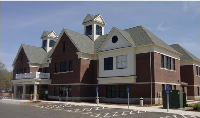


Property Detail
195 Eastern Blvd
GLAS-000004F-002100-W000005
HARTFORD
Commercialbuilding
Connecticut
PI
w0005
C and X Area of minimal flood hazard, usually depicted on FIRMs as above the 500-year flood level.
4.42 AC
2025
Glastonbury
2025
Hartford
520301
Hartford-West Hartford-East Hartford, CT
25,244 SF
NEARBY LISTINGS FOR SALE OR LEASE
DEMOGRAPHICS near 195 Eastern Blvd
1 mile
3 mile
5 mile
2025 Total Population
7,100
43,663
138,128
2030 Population
7,245
44,481
140,459
Pop Growth 2025-2030
+ 2.04%
+ 1.87%
+ 1.69%
Average Age
42
43
41
2025 Total Households
2,886
17,792
55,819
HH Growth 2025-2030
+ 2.08%
+ 1.89%
+ 1.74%
Median Household Inc
$102,733
$100,542
$82,196
Avg Household Size
2.40
2.40
2.40
2025 Avg HH Vehicles
2.00
2.00
2.00
Median Home Value
$332,807
$312,516
$292,762
Median Year Built
1975
1967
1961
Nearby Places
Map Layers
Map Styles
 Street
 Aerial
Layers
 Traffic
 Biking
Places
Listings with unknown addresses are not visible on the map
- Restaurants
- Banks
- Shops
- Fitness
- Groceries
PUBLIC TRANSPORTATION
COMMUTER RAIL
Hartford (Hartford Line - CONN DOT)
Drive
Walk
Distance
Hartford (Hartford Line - CONN DOT)
13 min
7.6 mi
Hartford Amtrak Station (Amtrak Hartford Line - Amtrak, Northeast Regional - Amtrak, Valley Flyer - Amtrak, Vermonter - Amtrak)
Drive
Walk
Distance
Hartford Amtrak Station (Amtrak Hartford Line - Amtrak, Northeast Regional - Amtrak, Valley Flyer - Amtrak, Vermonter - Amtrak)
13 min
7.7 mi
AIRPORT
Bradley International
Drive
Walk
Distance
Bradley International
42 min
23.6 mi
Freight Ports
Port of New Haven
Drive
Walk
Distance
Port of New Haven
54 min
39.9 mi
SALE & LEASE HISTORY
LISTING DATE
SALE/LEASE

Sep 25, 2016
For Lease
Aug 22, 2024
For Lease
Nearby Properties
Address
Land Use
TOTAL SIZE
Lot Size
Zoning
Address
Land Use
TOTAL SIZE
Lot Size
Zoning
159 AC
RR
Address
Land Use
TOTAL SIZE
Lot Size
Zoning
149.23 AC
DDD1
Address
Land Use
TOTAL SIZE
Lot Size
Zoning
112.42 AC
DDD1
Address
Land Use
TOTAL SIZE
Lot Size
Zoning
49,219 SF
31.72 AC
Address
Land Use
TOTAL SIZE
Lot Size
Zoning
55.64 AC
Address
Land Use
TOTAL SIZE
Lot Size
Zoning
348,943 SF
51.21 AC
R-2
Address
Land Use
TOTAL SIZE
Lot Size
Zoning
81,313 SF
4.44 AC
R-3
Address
Land Use
TOTAL SIZE
Lot Size
Zoning
188,454 SF
178.60 AC
A
Address
Land Use
TOTAL SIZE
Lot Size
Zoning
7.07 AC
PBD
Address
Land Use
TOTAL SIZE
Lot Size
Zoning
Address
Land Use
TOTAL SIZE
Lot Size
Zoning
11.95 AC
PAD
Address
Land Use
TOTAL SIZE
Lot Size
Zoning
15.12 AC
PAD
Address
Land Use
TOTAL SIZE
Lot Size
Zoning
Address
Land Use
TOTAL SIZE
Lot Size
Zoning
8.14 AC
Address
Land Use
TOTAL SIZE
Lot Size
Zoning
181,421 SF
18.36 AC
DDD1
Address
Land Use
TOTAL SIZE
Lot Size
Zoning
20.36 AC
B-1
Address
Land Use
TOTAL SIZE
Lot Size
Zoning
158,692 SF
2.89 AC
PAD
Address
Land Use
TOTAL SIZE
Lot Size
Zoning
105,294 SF
2.49 AC
PAD
Address
Land Use
TOTAL SIZE
Lot Size
Zoning
7.90 AC
Address
Land Use
TOTAL SIZE
Lot Size
Zoning
8.01 AC
I-3
Address
Land Use
TOTAL SIZE
Lot Size
Zoning
96,206 SF
2.83 AC
PAD
Address
Land Use
TOTAL SIZE
Lot Size
Zoning
3.06 AC
Address
Land Use
TOTAL SIZE
Lot Size
Zoning
71,728 SF
13.65 AC
Address
Land Use
TOTAL SIZE
Lot Size
Zoning
110,628 SF
28.81 AC
RR
Address
Land Use
TOTAL SIZE
Lot Size
Zoning
20,472 SF
10.59 AC
Address
Land Use
TOTAL SIZE
Lot Size
Zoning
5,603 SF
32.01 AC
Address
Land Use
TOTAL SIZE
Lot Size
Zoning
61,651 SF
9.98 AC
Address
Land Use
TOTAL SIZE
Lot Size
Zoning
50,648 SF
R-2
Address
Land Use
TOTAL SIZE
Lot Size
Zoning
57,457 SF
34.79 AC
Address
Land Use
TOTAL SIZE
Lot Size
Zoning
7.14 AC
The World's #1 Commercial Real Estate Marketplace
Connect with us
© 2026 CoStar Group
The information above has been obtained from sources believed reliable. While we do not doubt its accuracy we have not verified it and make no guarantee, warranty or representation about it. It is your responsibility to independently confirm its accuracy and completeness. Any projections, opinions, assumptions, or estimates used are for example only and do not represent the current or future performance of the property. The value of this transaction to you depends on tax and other factors which should be evaluated by your tax, financial, and legal advisors. You and your advisors should conduct a careful, independent investigation of the property to determine to your satisfaction the suitability of the property for your needs.