Property Record
195 Main Rd, Johns Island, SC 29455
Property Detail
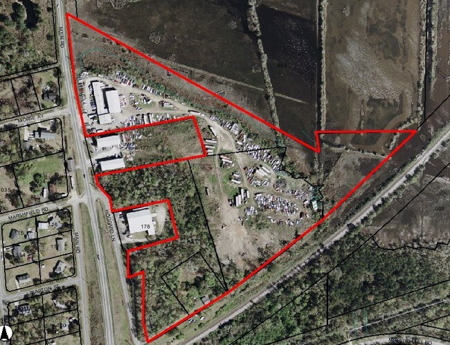
195 Main Rd
285-00-00-173
MAPPLATB L17 MAPPLATP 0401 SUBDIVISIONNAME CITY OF CHARLESTON TRACT A
Apartment
Charleston
AE The base floodplain where base flood elevations are provided. AE Zones are now used on new format FIRMs instead of A1-A30 Zones.
South Carolina
2025
14.81 AC
2024
West Ashley
005602
Charleston/N Charleston
4,500 SF
Charleston-North Charleston, SC
NEARBY LISTINGS FOR SALE OR LEASE
-
-
-
-
No Photo
-
View all Johns Island listings for sale on LoopNet.com
DEMOGRAPHICS near 195 Main Rd
1 mile
3 mile
5 mile
2025 Total Population
2,689
20,879
66,786
2030 Population
2,789
21,736
69,235
Pop Growth 2025-2030
+ 3.72%
+ 4.10%
+ 3.67%
Average Age
37
39
41
2025 Total Households
1,206
8,902
29,358
HH Growth 2025-2030
+ 3.73%
+ 4.09%
+ 3.72%
Median Household Inc
$93,049
$106,613
$99,790
Avg Household Size
2.20
2.30
2.20
2025 Avg HH Vehicles
2.00
2.00
2.00
Median Home Value
$399,999
$467,141
$424,612
Median Year Built
2010
2009
2000
Nearby Places
Map Layers
Map Styles
 Street
 Aerial
Layers
 Traffic
 Biking
Places
Listings with unknown addresses are not visible on the map
- Restaurants
- Banks
- Shops
- Fitness
- Groceries
PUBLIC TRANSPORTATION
AIRPORT
Charleston AFB/International
Drive
Walk
Distance
Charleston AFB/International
24 min
15.9 mi
Freight Ports
Columbus Street Terminal
Drive
Walk
Distance
Columbus Street Terminal
21 min
11.3 mi
Nearby Properties
Address
Land Use
TOTAL SIZE
Lot Size
Zoning
Address
Land Use
TOTAL SIZE
Lot Size
Zoning
49,853 SF
15.75 AC
Address
Land Use
TOTAL SIZE
Lot Size
Zoning
56.56 AC
Address
Land Use
TOTAL SIZE
Lot Size
Zoning
16.01 AC
Address
Land Use
TOTAL SIZE
Lot Size
Zoning
5,421 SF
22.92 AC
Address
Land Use
TOTAL SIZE
Lot Size
Zoning
Address
Land Use
TOTAL SIZE
Lot Size
Zoning
17,550 SF
24.36 AC
Address
Land Use
TOTAL SIZE
Lot Size
Zoning
13.30 AC
Address
Land Use
TOTAL SIZE
Lot Size
Zoning
Address
Land Use
TOTAL SIZE
Lot Size
Zoning
7,492 SF
9.54 AC
Address
Land Use
TOTAL SIZE
Lot Size
Zoning
8,922 SF
27.21 AC
Address
Land Use
TOTAL SIZE
Lot Size
Zoning
5,632 SF
16.98 AC
Address
Land Use
TOTAL SIZE
Lot Size
Zoning
7,900 SF
16.38 AC
Address
Land Use
TOTAL SIZE
Lot Size
Zoning
Address
Land Use
TOTAL SIZE
Lot Size
Zoning
146.70 AC
Address
Land Use
TOTAL SIZE
Lot Size
Zoning
400 SF
19.83 AC
Address
Land Use
TOTAL SIZE
Lot Size
Zoning
22,578 SF
23.54 AC
Address
Land Use
TOTAL SIZE
Lot Size
Zoning
14.07 AC
Address
Land Use
TOTAL SIZE
Lot Size
Zoning
35.14 AC
Address
Land Use
TOTAL SIZE
Lot Size
Zoning
1,800 SF
0.83 AC
Address
Land Use
TOTAL SIZE
Lot Size
Zoning
9.10 AC
Address
Land Use
TOTAL SIZE
Lot Size
Zoning
Address
Land Use
TOTAL SIZE
Lot Size
Zoning
203,812 SF
28.52 AC
Address
Land Use
TOTAL SIZE
Lot Size
Zoning
3.40 AC
Address
Land Use
TOTAL SIZE
Lot Size
Zoning
1,342 SF
7.76 AC
Address
Land Use
TOTAL SIZE
Lot Size
Zoning
1.91 AC
Address
Land Use
TOTAL SIZE
Lot Size
Zoning
3,270 SF
5.50 AC
Address
Land Use
TOTAL SIZE
Lot Size
Zoning
69.97 AC
Address
Land Use
TOTAL SIZE
Lot Size
Zoning
10,500 SF
5.78 AC
Address
Land Use
TOTAL SIZE
Lot Size
Zoning
8.41 AC
The World's #1 Commercial Real Estate Marketplace
Connect with us
© 2026 CoStar Group
The information above has been obtained from sources believed reliable. While we do not doubt its accuracy we have not verified it and make no guarantee, warranty or representation about it. It is your responsibility to independently confirm its accuracy and completeness. Any projections, opinions, assumptions, or estimates used are for example only and do not represent the current or future performance of the property. The value of this transaction to you depends on tax and other factors which should be evaluated by your tax, financial, and legal advisors. You and your advisors should conduct a careful, independent investigation of the property to determine to your satisfaction the suitability of the property for your needs.