Property Record
195 Ridgeline Rd, Carthage, NC 28327


NEARBY LISTINGS FOR SALE OR LEASE
-
-
View all Carthage listings for lease on LoopNet.com
Property Detail
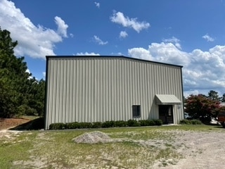
195 Ridgeline Rd
Pinehurst-Southern Pines, NC
Sandy Mine Commerce Park
8550-08-98-8336
SANDYMINE COMM LOT 19
Lightindustrial
Moore
X
North Carolina
3710854000J
19
2024
2.57 AC
2024
North Carolina Southeast Area
950403
Other Market Areas
7,200 SF
DEMOGRAPHICS near 195 Ridgeline Rd
1 Mile
3 Mile
5 Mile
2024 Total Population
1,075
16,728
44,860
2029 Population
1,252
19,320
51,924
Pop Growth 2024-2029
+ 16.47%
+ 15.49%
+ 15.75%
Average Age
41
44
44
2024 Total Households
437
7,230
19,746
HH Growth 2024-2029
+ 16.93%
+ 15.81%
+ 16.02%
Median Household Inc
$63,333
$71,835
$71,297
Avg Household Size
2.40
2.30
2.20
2024 Avg HH Vehicles
2.00
2.00
2.00
Median Home Value
$249,324
$314,172
$356,312
Median Year Built
1995
1993
1994
Nearby Places
Map Layers
Map Styles
 Street
 Aerial
- Restaurants
- Banks
- Shops
- Fitness
- Groceries
PUBLIC TRANSPORTATION
COMMUTER RAIL
Southern Pines Amtrak Station (Silver Star - Amtrak)
DRIVE
WALK
Distance
Southern Pines Amtrak Station (Silver Star - Amtrak)
12 min
6.9 mi
Freight Ports
Port of Wilmington
DRIVE
WALK
Distance
Port of Wilmington
169 min
133.6 mi
SALE & LEASE HISTORY
LISTING DATE
SALE/LEASE

Sep 26, 2022
For Lease
Nearby Properties
Address
Land Use
TOTAL SIZE
Lot Size
Zoning
Address
Land Use
TOTAL SIZE
Lot Size
Zoning
16.26 AC
PD
Address
Land Use
TOTAL SIZE
Lot Size
Zoning
21,138 SF
473.33 AC
RD
Address
Land Use
TOTAL SIZE
Lot Size
Zoning
22,772 SF
12.46 AC
HC
Address
Land Use
TOTAL SIZE
Lot Size
Zoning
83,896 SF
66.98 AC
R20
Address
Land Use
TOTAL SIZE
Lot Size
Zoning
4,992 SF
14.75 AC
PD
Address
Land Use
TOTAL SIZE
Lot Size
Zoning
155.66 AC
RD
Address
Land Use
TOTAL SIZE
Lot Size
Zoning
199,100 SF
24.89 AC
HC
Address
Land Use
TOTAL SIZE
Lot Size
Zoning
2,450 SF
2.96 AC
Address
Land Use
TOTAL SIZE
Lot Size
Zoning
0.84 AC
GC
Address
Land Use
TOTAL SIZE
Lot Size
Zoning
9,690 SF
19.96 AC
HC
Address
Land Use
TOTAL SIZE
Lot Size
Zoning
47,273 SF
11.25 AC
NC
Address
Land Use
TOTAL SIZE
Lot Size
Zoning
23,472 SF
3.49 AC
GC
Address
Land Use
TOTAL SIZE
Lot Size
Zoning
Address
Land Use
TOTAL SIZE
Lot Size
Zoning
5,090 SF
99.55 AC
RD
Address
Land Use
TOTAL SIZE
Lot Size
Zoning
8,169 SF
8.15 AC
GB
Address
Land Use
TOTAL SIZE
Lot Size
Zoning
29,820 SF
2.11 AC
Address
Land Use
TOTAL SIZE
Lot Size
Zoning
29,346 SF
3.50 AC
GB
Address
Land Use
TOTAL SIZE
Lot Size
Zoning
9,832 SF
1.71 AC
B3
Address
Land Use
TOTAL SIZE
Lot Size
Zoning
9,790 SF
40.16 AC
CI
Address
Land Use
TOTAL SIZE
Lot Size
Zoning
11,280 SF
6.91 AC
R6
Address
Land Use
TOTAL SIZE
Lot Size
Zoning
6,084 SF
1.31 AC
Address
Land Use
TOTAL SIZE
Lot Size
Zoning
676 SF
140.23 AC
R210
Address
Land Use
TOTAL SIZE
Lot Size
Zoning
6,900 SF
21.62 AC
CI
Address
Land Use
TOTAL SIZE
Lot Size
Zoning
24,016 SF
8.61 AC
MULTI
Address
Land Use
TOTAL SIZE
Lot Size
Zoning
94.90 AC
RD
Address
Land Use
TOTAL SIZE
Lot Size
Zoning
29,759 SF
1.26 AC
GB
Address
Land Use
TOTAL SIZE
Lot Size
Zoning
7,800 SF
4.22 AC
HC
Address
Land Use
TOTAL SIZE
Lot Size
Zoning
1,560 SF
110.82 AC
PC
Address
Land Use
TOTAL SIZE
Lot Size
Zoning
5,360 SF
67.09 AC
Address
Land Use
TOTAL SIZE
Lot Size
Zoning
127.20 AC
RD
The World's #1 Commercial Real Estate Marketplace
Connect with us
© 2025 CoStar Group
The information above has been obtained from sources believed reliable. While we do not doubt its accuracy we have not verified it and make no guarantee, warranty or representation about it. It is your responsibility to independently confirm its accuracy and completeness. Any projections, opinions, assumptions, or estimates used are for example only and do not represent the current or future performance of the property. The value of this transaction to you depends on tax and other factors which should be evaluated by your tax, financial, and legal advisors. You and your advisors should conduct a careful, independent investigation of the property to determine to your satisfaction the suitability of the property for your needs.