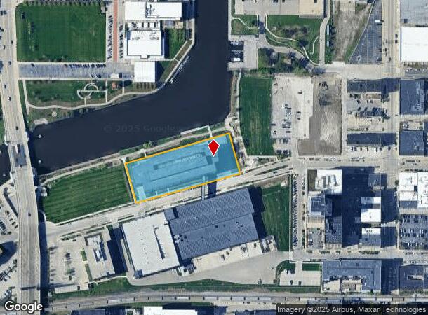
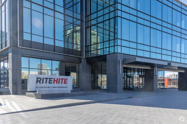
Property Record
195 S Rite Hite Way, Milwaukee, WI 53204

NEARBY LISTINGS FOR SALE OR LEASE
Property Detail
195 S Rite Hite Way
Milwaukee-Waukesha, WI
CERTIFIED SURVEY MAP NO 9271 IN NE 1/4 SEC 32-7-22 LOT 1 BID #49 TID #75 BID #26
428-1161-000
Milwaukee
Commercialnec
Wisconsin
2024
1
2024
1.70 AC
187400
Third Ward/Walkers Pt
173,610 SF
Milwaukee/Madison
DEMOGRAPHICS near 195 S Rite Hite Way
1 Mile
3 Mile
5 Mile
2024 Total Population
18,640
199,490
435,799
2029 Population
18,513
196,234
428,116
Pop Growth 2024-2029
(0.68%)
(1.63%)
(1.76%)
Average Age
33
34
36
2024 Total Households
8,610
85,051
184,543
HH Growth 2024-2029
(0.26%)
(1.50%)
(1.78%)
Median Household Inc
$63,038
$42,360
$48,535
Avg Household Size
1.90
2.20
2.20
2024 Avg HH Vehicles
1.00
1.00
1.00
Median Home Value
$254,426
$167,586
$177,962
Median Year Built
1948
1948
1948
Nearby Places
Map Layers
Map Styles
 Street
 Aerial
- Restaurants
- Banks
- Shops
- Fitness
- Groceries
PUBLIC TRANSPORTATION
COMMUTER RAIL
Milwaukee (Empire Builder - Amtrak)
DRIVE
WALK
Distance
Milwaukee (Empire Builder - Amtrak)
2 min
14 min
0.7 mi
General Mitchell Intl. Airport Amtrak Station (Hiawatha Service - Amtrak)
DRIVE
WALK
Distance
General Mitchell Intl. Airport Amtrak Station (Hiawatha Service - Amtrak)
16 min
6.9 mi
AIRPORT
General Mitchell International
DRIVE
WALK
Distance
General Mitchell International
15 min
6.9 mi
Freight Ports
Port Milwaukee
DRIVE
WALK
Distance
Port Milwaukee
6 min
2.1 mi
SALE & LEASE HISTORY
LISTING DATE
SALE/LEASE

Sep 25, 2016
For Lease
Jan 02, 2018
For Lease
Nearby Properties
Address
Land Use
TOTAL SIZE
Lot Size
Zoning
Address
Land Use
TOTAL SIZE
Lot Size
Zoning
1,140,196 SF
5.33 AC
C9F(A)
Address
Land Use
TOTAL SIZE
Lot Size
Zoning
8.05 AC
TL
Address
Land Use
TOTAL SIZE
Lot Size
Zoning
730,000 SF
6.94 AC
PD
Address
Land Use
TOTAL SIZE
Lot Size
Zoning
237,850 SF
5.02 AC
RM7
Address
Land Use
TOTAL SIZE
Lot Size
Zoning
1,330,372 SF
2.48 AC
C9F(A)
Address
Land Use
TOTAL SIZE
Lot Size
Zoning
41.05 AC
IO2
Address
Land Use
TOTAL SIZE
Lot Size
Zoning
715,000 SF
2.71 AC
C9F(B)
Address
Land Use
TOTAL SIZE
Lot Size
Zoning
3.04 AC
TL
Address
Land Use
TOTAL SIZE
Lot Size
Zoning
523,726 SF
0.79 AC
C9B(B)
Address
Land Use
TOTAL SIZE
Lot Size
Zoning
607,577 SF
1.67 AC
PD
Address
Land Use
TOTAL SIZE
Lot Size
Zoning
370,160 SF
2.93 AC
C9F(A)
Address
Land Use
TOTAL SIZE
Lot Size
Zoning
380,817 SF
0.82 AC
C9F(A)
Address
Land Use
TOTAL SIZE
Lot Size
Zoning
362,007 SF
1.02 AC
C9F(A)
Address
Land Use
TOTAL SIZE
Lot Size
Zoning
495,212 SF
0.48 AC
C9F(A)
Address
Land Use
TOTAL SIZE
Lot Size
Zoning
414,410 SF
2.16 AC
C9F(A)
Address
Land Use
TOTAL SIZE
Lot Size
Zoning
280,000 SF
2.74 AC
RED
Address
Land Use
TOTAL SIZE
Lot Size
Zoning
417,704 SF
0.81 AC
PD
Address
Land Use
TOTAL SIZE
Lot Size
Zoning
378,717 SF
0.61 AC
C9D(A)
Address
Land Use
TOTAL SIZE
Lot Size
Zoning
535,904 SF
3.88 AC
C9A(A)
Address
Land Use
TOTAL SIZE
Lot Size
Zoning
491,759 SF
3 AC
C9F(A)
Address
Land Use
TOTAL SIZE
Lot Size
Zoning
272,475 SF
0.66 AC
PD
Address
Land Use
TOTAL SIZE
Lot Size
Zoning
319,559 SF
6.29 AC
PD
Address
Land Use
TOTAL SIZE
Lot Size
Zoning
300,416 SF
1.24 AC
PD
Address
Land Use
TOTAL SIZE
Lot Size
Zoning
4.53 AC
C9F(A)
Address
Land Use
TOTAL SIZE
Lot Size
Zoning
382,921 SF
2.81 AC
PD
Address
Land Use
TOTAL SIZE
Lot Size
Zoning
425,000 SF
1.42 AC
C9F(A)
Address
Land Use
TOTAL SIZE
Lot Size
Zoning
179 AC
IH
Address
Land Use
TOTAL SIZE
Lot Size
Zoning
180,407 SF
0.63 AC
PD
Address
Land Use
TOTAL SIZE
Lot Size
Zoning
534,786 SF
1.81 AC
C9D(A)
The World's #1 Commercial Real Estate Marketplace
Connect with us
© 2026 CoStar Group
The information above has been obtained from sources believed reliable. While we do not doubt its accuracy we have not verified it and make no guarantee, warranty or representation about it. It is your responsibility to independently confirm its accuracy and completeness. Any projections, opinions, assumptions, or estimates used are for example only and do not represent the current or future performance of the property. The value of this transaction to you depends on tax and other factors which should be evaluated by your tax, financial, and legal advisors. You and your advisors should conduct a careful, independent investigation of the property to determine to your satisfaction the suitability of the property for your needs.