Property Record
195 Willow Bend Ct, Kernersville, NC 27284
NEARBY LISTINGS FOR SALE OR LEASE
-
-
View all Kernersville listings for sale on LoopNet.com
Property Detail
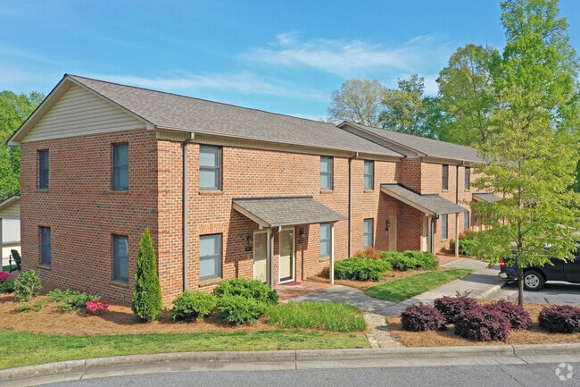
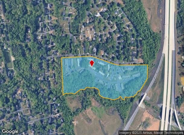
195 Willow Bend Ct
Winston-Salem, NC
Kerner Mill Townhomes
6866-54-0168
KERNER MILL TOWNHOMES LO:101B BL:5342D BU:1
Apartment
Forsyth
AE
North Carolina
3710686600J
101b
2024
27.95 AC
2025
Kernersville
003004
Greensboro/Winston-Salem
288 SF
DEMOGRAPHICS near 195 Willow Bend Ct
1 Mile
3 Mile
5 Mile
2024 Total Population
2,922
31,458
84,286
2029 Population
3,013
32,681
87,772
Pop Growth 2024-2029
+ 3.11%
+ 3.89%
+ 4.14%
Average Age
42
41
41
2024 Total Households
1,170
12,699
34,164
HH Growth 2024-2029
+ 3.16%
+ 3.87%
+ 4.14%
Median Household Inc
$68,628
$79,860
$62,314
Avg Household Size
2.50
2.40
2.40
2024 Avg HH Vehicles
2.00
2.00
2.00
Median Home Value
$249,350
$222,100
$203,636
Median Year Built
1986
1988
1985
Nearby Places
Map Layers
Map Styles
 Street
 Aerial
- Restaurants
- Banks
- Shops
- Fitness
- Groceries
PUBLIC TRANSPORTATION
AIRPORT
Piedmont Triad International
DRIVE
WALK
Distance
Piedmont Triad International
29 min
15.5 mi
Freight Ports
Virginia Port Authority - Richmond
DRIVE
WALK
Distance
Virginia Port Authority - Richmond
256 min
219.1 mi
Nearby Properties
Address
Land Use
TOTAL SIZE
Lot Size
Zoning
Address
Land Use
TOTAL SIZE
Lot Size
Zoning
576,252 SF
59.82 AC
GI,LI
Address
Land Use
TOTAL SIZE
Lot Size
Zoning
188,273 SF
54.55 AC
IP
Address
Land Use
TOTAL SIZE
Lot Size
Zoning
70,113 SF
19.06 AC
RM18-S
Address
Land Use
TOTAL SIZE
Lot Size
Zoning
115,838 SF
14.41 AC
GI-C
Address
Land Use
TOTAL SIZE
Lot Size
Zoning
202,539 SF
23.70 AC
HB-S
Address
Land Use
TOTAL SIZE
Lot Size
Zoning
545,857 SF
51.60 AC
GI
Address
Land Use
TOTAL SIZE
Lot Size
Zoning
451.32 AC
MU-C
Address
Land Use
TOTAL SIZE
Lot Size
Zoning
136,068 SF
19.46 AC
HB-S
Address
Land Use
TOTAL SIZE
Lot Size
Zoning
121,981 SF
14.48 AC
HB-S
Address
Land Use
TOTAL SIZE
Lot Size
Zoning
83,774 SF
7.51 AC
GB-S
Address
Land Use
TOTAL SIZE
Lot Size
Zoning
83,027 SF
14.47 AC
HB-S,LO-S
Address
Land Use
TOTAL SIZE
Lot Size
Zoning
98,617 SF
37.44 AC
RS20
Address
Land Use
TOTAL SIZE
Lot Size
Zoning
122,682 SF
9.07 AC
HB-S
Address
Land Use
TOTAL SIZE
Lot Size
Zoning
102,809 SF
16.74 AC
BI
Address
Land Use
TOTAL SIZE
Lot Size
Zoning
77,891 SF
20.91 AC
RS9
Address
Land Use
TOTAL SIZE
Lot Size
Zoning
52,480 SF
30.51 AC
BI
Address
Land Use
TOTAL SIZE
Lot Size
Zoning
93,437 SF
11.59 AC
HB-S
Address
Land Use
TOTAL SIZE
Lot Size
Zoning
71,538 SF
9.02 AC
IP
Address
Land Use
TOTAL SIZE
Lot Size
Zoning
378,330 SF
74.78 AC
GI,GI-S,RS
Address
Land Use
TOTAL SIZE
Lot Size
Zoning
52,792 SF
25.21 AC
BI
Address
Land Use
TOTAL SIZE
Lot Size
Zoning
66,963 SF
5.67 AC
HB-S
Address
Land Use
TOTAL SIZE
Lot Size
Zoning
75,229 SF
23.45 AC
IP
Address
Land Use
TOTAL SIZE
Lot Size
Zoning
89,697 SF
5.99 AC
RM18-S
Address
Land Use
TOTAL SIZE
Lot Size
Zoning
55,634 SF
8.42 AC
RM12-S
Address
Land Use
TOTAL SIZE
Lot Size
Zoning
42,287 SF
6.29 AC
NSB-S
Address
Land Use
TOTAL SIZE
Lot Size
Zoning
44,172 SF
4.50 AC
HB-S
Address
Land Use
TOTAL SIZE
Lot Size
Zoning
49,323 SF
4.27 AC
GB-S
Address
Land Use
TOTAL SIZE
Lot Size
Zoning
73,732 SF
8.05 AC
IP
Address
Land Use
TOTAL SIZE
Lot Size
Zoning
87,759 SF
253.32 AC
GI,GI-S,RS
The World's #1 Commercial Real Estate Marketplace
Connect with us
© 2026 CoStar Group
The information above has been obtained from sources believed reliable. While we do not doubt its accuracy we have not verified it and make no guarantee, warranty or representation about it. It is your responsibility to independently confirm its accuracy and completeness. Any projections, opinions, assumptions, or estimates used are for example only and do not represent the current or future performance of the property. The value of this transaction to you depends on tax and other factors which should be evaluated by your tax, financial, and legal advisors. You and your advisors should conduct a careful, independent investigation of the property to determine to your satisfaction the suitability of the property for your needs.