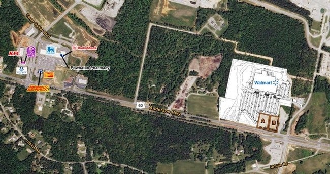
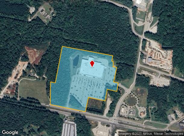
Property Record
1950 Anderson Hwy, Powhatan, VA 23139
NEARBY LISTINGS FOR SALE OR LEASE
-
-
-
-
-
No Photo
-
View all Powhatan listings for sale on LoopNet.com
Property Detail
1950 Anderson Hwy
042-6-1
ANDERSON HIGHWAY PARCEL 1
Multipleuses
Powhatan
X
Virginia
51145C0150C
1
2025
29.73 AC
2025
Powhatan
500101
Richmond VA
149,648 SF
Richmond, VA
DEMOGRAPHICS near 1950 Anderson Hwy
1 Mile
3 Mile
5 Mile
2024 Total Population
606
4,697
16,869
2029 Population
660
5,136
18,654
Pop Growth 2024-2029
+ 8.91%
+ 9.35%
+ 10.58%
Average Age
43
43
41
2024 Total Households
236
1,788
6,058
HH Growth 2024-2029
+ 9.32%
+ 9.62%
+ 10.68%
Median Household Inc
$119,414
$119,947
$129,671
Avg Household Size
2.60
2.60
2.70
2024 Avg HH Vehicles
3.00
3.00
3.00
Median Home Value
$335,000
$361,922
$420,672
Median Year Built
1984
1988
1996
Nearby Places
Map Layers
Map Styles
 Street
 Aerial
- Restaurants
- Banks
- Shops
- Fitness
- Groceries
PUBLIC TRANSPORTATION
AIRPORT
Richmond International
DRIVE
WALK
Distance
Richmond International
51 min
32.4 mi
Freight Ports
Virginia Port Authority - Richmond
DRIVE
WALK
Distance
Virginia Port Authority - Richmond
41 min
22.5 mi
SALE & LEASE HISTORY
LISTING DATE
SALE/LEASE

Sep 24, 2016
For Sale
Nearby Properties
Address
Land Use
TOTAL SIZE
Lot Size
Zoning
Address
Land Use
TOTAL SIZE
Lot Size
Zoning
291,788 SF
61.70 AC
A-10
Address
Land Use
TOTAL SIZE
Lot Size
Zoning
96,428 SF
20.87 AC
A-10
Address
Land Use
TOTAL SIZE
Lot Size
Zoning
149,648 SF
29.73 AC
CC
Address
Land Use
TOTAL SIZE
Lot Size
Zoning
61,231 SF
7.80 AC
CC
Address
Land Use
TOTAL SIZE
Lot Size
Zoning
15,322 SF
37.84 AC
I-2
Address
Land Use
TOTAL SIZE
Lot Size
Zoning
49,360 SF
17 AC
I-2
Address
Land Use
TOTAL SIZE
Lot Size
Zoning
1,800 SF
5.25 AC
CC
Address
Land Use
TOTAL SIZE
Lot Size
Zoning
2,309 SF
10.79 AC
A-10
Address
Land Use
TOTAL SIZE
Lot Size
Zoning
21,914 SF
6.95 AC
CC
Address
Land Use
TOTAL SIZE
Lot Size
Zoning
55,489 SF
10.09 AC
CC
Address
Land Use
TOTAL SIZE
Lot Size
Zoning
15,690 SF
3.71 AC
CC
Address
Land Use
TOTAL SIZE
Lot Size
Zoning
12,992 SF
5.09 AC
I-1
Address
Land Use
TOTAL SIZE
Lot Size
Zoning
19,810 SF
1.56 AC
I-1
Address
Land Use
TOTAL SIZE
Lot Size
Zoning
650 AC
A-10
Address
Land Use
TOTAL SIZE
Lot Size
Zoning
12,000 SF
5.08 AC
CC
Address
Land Use
TOTAL SIZE
Lot Size
Zoning
5,928 SF
2.75 AC
CC
Address
Land Use
TOTAL SIZE
Lot Size
Zoning
43.14 AC
I-1
Address
Land Use
TOTAL SIZE
Lot Size
Zoning
15,620 SF
2.48 AC
CC
Address
Land Use
TOTAL SIZE
Lot Size
Zoning
9,000 SF
3.47 AC
CC
Address
Land Use
TOTAL SIZE
Lot Size
Zoning
5,331 SF
2 AC
CC
Address
Land Use
TOTAL SIZE
Lot Size
Zoning
11,568 SF
14.22 AC
A-10
Address
Land Use
TOTAL SIZE
Lot Size
Zoning
6,624 SF
4.51 AC
I-2
Address
Land Use
TOTAL SIZE
Lot Size
Zoning
9,710 SF
1.68 AC
CC
Address
Land Use
TOTAL SIZE
Lot Size
Zoning
10,086 SF
1.58 AC
CC
Address
Land Use
TOTAL SIZE
Lot Size
Zoning
11,121 SF
6.22 AC
CC
Address
Land Use
TOTAL SIZE
Lot Size
Zoning
10,080 SF
7.34 AC
I-1
Address
Land Use
TOTAL SIZE
Lot Size
Zoning
1,740 SF
151.02 AC
M
Address
Land Use
TOTAL SIZE
Lot Size
Zoning
3,500 SF
2.08 AC
CC
The World's #1 Commercial Real Estate Marketplace
Connect with us
© 2025 CoStar Group
The information above has been obtained from sources believed reliable. While we do not doubt its accuracy we have not verified it and make no guarantee, warranty or representation about it. It is your responsibility to independently confirm its accuracy and completeness. Any projections, opinions, assumptions, or estimates used are for example only and do not represent the current or future performance of the property. The value of this transaction to you depends on tax and other factors which should be evaluated by your tax, financial, and legal advisors. You and your advisors should conduct a careful, independent investigation of the property to determine to your satisfaction the suitability of the property for your needs.