Property Record
1950 Byron Center Ave Sw, Wyoming, MI 49519

NEARBY LISTINGS FOR SALE OR LEASE
Property Detail
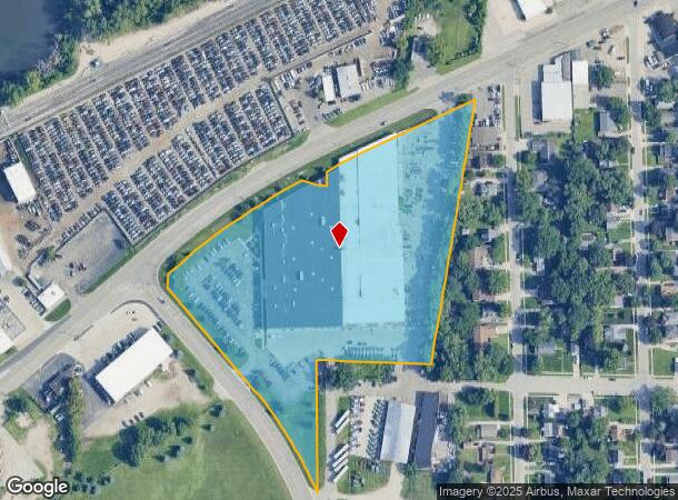
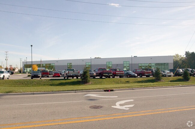
1950 Byron Center Ave Sw
41-17-03-352-008
Th E Along Sd N Line To W Line Of Grapew
Industrialgeneral
PART OF SW 1/4 SEC 3 COM AT INT OF CL OF CHICAGO DR & W SEC LINE TH S ALONG W SEC LINE TO N LINE OF S 50 FT OF SW 1/4 TH E
X
Kent
26081C0411D
Michigan
2024
9.03 AC
2025
Central Grand Rapids
013400
West Michigan
144,192 SF
Grand Rapids-Wyoming, MI
DEMOGRAPHICS near 1950 Byron Center Ave Sw
1 Mile
3 Mile
5 Mile
2024 Total Population
5,041
74,414
237,068
2029 Population
5,064
74,673
238,996
Pop Growth 2024-2029
+ 0.46%
+ 0.35%
+ 0.81%
Average Age
37
36
37
2024 Total Households
1,832
26,988
93,574
HH Growth 2024-2029
+ 0.49%
+ 0.49%
+ 0.91%
Median Household Inc
$66,117
$58,569
$61,688
Avg Household Size
2.60
2.60
2.40
2024 Avg HH Vehicles
2.00
2.00
2.00
Median Home Value
$148,255
$162,237
$194,505
Median Year Built
1954
1959
1959
Nearby Places
Map Layers
Map Styles
 Street
 Aerial
- Restaurants
- Banks
- Shops
- Fitness
- Groceries
PUBLIC TRANSPORTATION
COMMUTER RAIL
Grand Rapids Vernon J. Ehlers Station (Pere Marquette - Amtrak)
DRIVE
WALK
Distance
Grand Rapids Vernon J. Ehlers Station (Pere Marquette - Amtrak)
8 min
4.1 mi
AIRPORT
Gerald R Ford International
DRIVE
WALK
Distance
Gerald R Ford International
26 min
14.6 mi
Freight Ports
Port Milwaukee
DRIVE
WALK
Distance
Port Milwaukee
300 min
258.5 mi
Nearby Properties
Address
Land Use
TOTAL SIZE
Lot Size
Zoning
Address
Land Use
TOTAL SIZE
Lot Size
Zoning
899,034 SF
78.93 AC
B1
Address
Land Use
TOTAL SIZE
Lot Size
Zoning
12.64 AC
PUD
Address
Land Use
TOTAL SIZE
Lot Size
Zoning
398,607 SF
33.51 AC
R4
Address
Land Use
TOTAL SIZE
Lot Size
Zoning
343,973 SF
29.15 AC
MON-LDR
Address
Land Use
TOTAL SIZE
Lot Size
Zoning
87.39 AC
I2
Address
Land Use
TOTAL SIZE
Lot Size
Zoning
29.13 AC
Address
Land Use
TOTAL SIZE
Lot Size
Zoning
293,441 SF
18 AC
I-1
Address
Land Use
TOTAL SIZE
Lot Size
Zoning
251,562 SF
15.56 AC
MZ
Address
Land Use
TOTAL SIZE
Lot Size
Zoning
162,228 SF
14.31 AC
R4
Address
Land Use
TOTAL SIZE
Lot Size
Zoning
Address
Land Use
TOTAL SIZE
Lot Size
Zoning
248,360 SF
7.03 AC
SD-IT
Address
Land Use
TOTAL SIZE
Lot Size
Zoning
155,304 SF
17.58 AC
R3-B
Address
Land Use
TOTAL SIZE
Lot Size
Zoning
116,832 SF
14.32 AC
R4
Address
Land Use
TOTAL SIZE
Lot Size
Zoning
246,880 SF
18.33 AC
I-2
Address
Land Use
TOTAL SIZE
Lot Size
Zoning
260,000 SF
10.49 AC
SD-IT
Address
Land Use
TOTAL SIZE
Lot Size
Zoning
121,842 SF
9.42 AC
R4
Address
Land Use
TOTAL SIZE
Lot Size
Zoning
143,447 SF
10.72 AC
R4
Address
Land Use
TOTAL SIZE
Lot Size
Zoning
330,139 SF
19.25 AC
SD-IT
Address
Land Use
TOTAL SIZE
Lot Size
Zoning
175,940 SF
12.30 AC
SD-IT
Address
Land Use
TOTAL SIZE
Lot Size
Zoning
212,111 SF
10.10 AC
SD-IT
Address
Land Use
TOTAL SIZE
Lot Size
Zoning
16.42 AC
Address
Land Use
TOTAL SIZE
Lot Size
Zoning
121,602 SF
45.20 AC
I-2
Address
Land Use
TOTAL SIZE
Lot Size
Zoning
94,880 SF
10.57 AC
R4
Address
Land Use
TOTAL SIZE
Lot Size
Zoning
404,476 SF
13.07 AC
I2
Address
Land Use
TOTAL SIZE
Lot Size
Zoning
60,510 SF
13.84 AC
FBC
Address
Land Use
TOTAL SIZE
Lot Size
Zoning
365,572 SF
29.56 AC
FBC
Address
Land Use
TOTAL SIZE
Lot Size
Zoning
339,300 SF
12.46 AC
SD-IT
Address
Land Use
TOTAL SIZE
Lot Size
Zoning
Address
Land Use
TOTAL SIZE
Lot Size
Zoning
134,943 SF
5.01 AC
I2
The World's #1 Commercial Real Estate Marketplace
Connect with us
© 2025 CoStar Group
The information above has been obtained from sources believed reliable. While we do not doubt its accuracy we have not verified it and make no guarantee, warranty or representation about it. It is your responsibility to independently confirm its accuracy and completeness. Any projections, opinions, assumptions, or estimates used are for example only and do not represent the current or future performance of the property. The value of this transaction to you depends on tax and other factors which should be evaluated by your tax, financial, and legal advisors. You and your advisors should conduct a careful, independent investigation of the property to determine to your satisfaction the suitability of the property for your needs.